
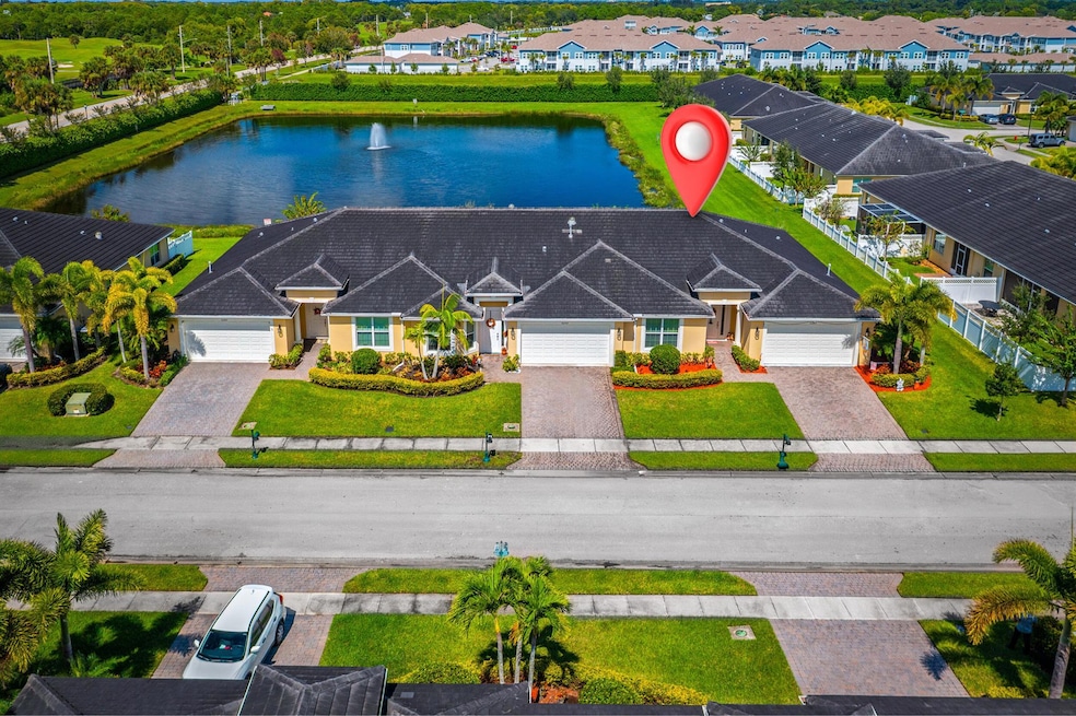
6244 NW Helmsdale Way Port Saint Lucie, FL 34983
Saint Lucie North NeighborhoodEstimated payment $2,822/month
Total Views
7,582
3
Beds
2
Baths
1,920
Sq Ft
$180
Price per Sq Ft
Highlights
- Lake Front
- Gated Community
- Great Room
- Morningside Elementary School Rated 9+
- Clubhouse
- Screened Porch
About This Home
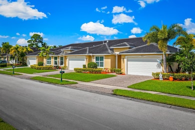
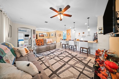
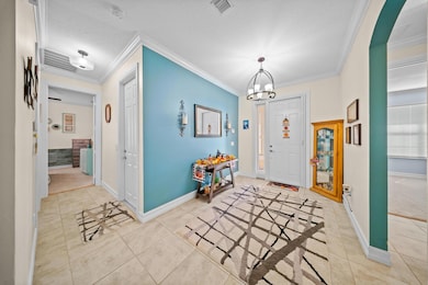
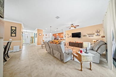
Enjoy low-maintenance living and more affordable homeowners insurance in this 2018 CBS-built 3-bedroom, 2-bath home. This 1,920 sq ft property features an open-concept layout with tile flooring, a modern kitchen with quartz countertops and stainless steel appliances, gas range, and a screened patio overlooking a peaceful pond. The primary suite offers dual walk-in closets, double vanities, and a tiled shower. Additional features include a concrete tile roof, fenced yard, two-car garage, and energy-efficient systems in a gated community minutes from I-95 and St. Lucie West.
Home Details
Home Type
- Single Family
Est. Annual Taxes
- $5,287
Year Built
- Built in 2018
Lot Details
- 4,704 Sq Ft Lot
- Lake Front
- Sprinkler System
HOA Fees
- $571 Monthly HOA Fees
Parking
- 2 Car Attached Garage
- Garage Door Opener
Home Design
- Villa
- Flat Roof Shape
- Tile Roof
Interior Spaces
- 1,920 Sq Ft Home
- 1-Story Property
- Ceiling Fan
- Great Room
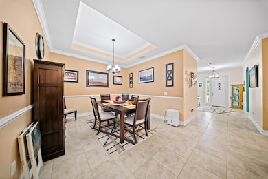
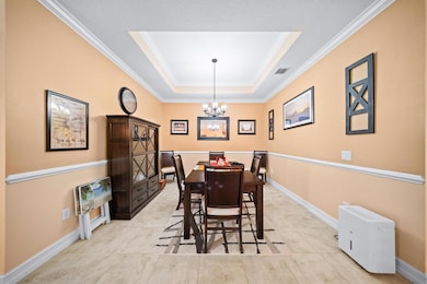
- Formal Dining Room
- Screened Porch
- Lake Views
Kitchen
- Electric Range
- Microwave
- Dishwasher
Flooring
- Carpet
- Ceramic Tile
Bedrooms and Bathrooms
- 3 Bedrooms | 2 Main Level Bedrooms
- Split Bedroom Floorplan
- Walk-In Closet
- 2 Full Bathrooms
- Separate Shower in Primary Bathroom
Laundry
- Laundry Room
- Washer and Dryer
Home Security
- Security Gate
- Impact Glass
Outdoor Features
- Patio
Utilities
- Central Heating and Cooling System
- Cable TV Available
Listing and Financial Details
- Assessor Parcel Number 340870500050000
Community Details
Overview
- Association fees include common areas, cable TV, ground maintenance, security
- St Andrews Townhomes Repl Subdivision
Recreation
- Community Pool
- Community Spa
Additional Features
- Clubhouse
- Gated Community
Map
Create a Home Valuation Report for This Property
The Home Valuation Report is an in-depth analysis detailing your home's value as well as a comparison with similar homes in the area
Home Values in the Area
Average Home Value in this Area
Tax History
| Year | Tax Paid | Tax Assessment Tax Assessment Total Assessment is a certain percentage of the fair market value that is determined by local assessors to be the total taxable value of land and additions on the property. | Land | Improvement |
|---|---|---|---|---|
| 2025 | $5,287 | $263,717 | -- | -- |
| 2024 | $5,178 | $256,285 | -- | -- |
| 2023 | $5,178 | $248,821 | $0 | $0 |
| 2022 | $4,725 | $241,574 | $0 | $0 |
| 2021 | $4,767 | $234,538 | $0 | $0 |
| 2020 | $4,809 | $231,300 | $0 | $231,300 |
| 2019 | $5,343 | $248,400 | $0 | $248,400 |
| 2018 | $656 | $20,000 | $20,000 | $0 |
| 2017 | $498 | $15,000 | $15,000 | $0 |
| 2016 | $498 | $15,000 | $15,000 | $0 |
Source: Public Records
Property History
| Date | Event | Price | List to Sale | Price per Sq Ft |
|---|---|---|---|---|
| 12/02/2025 12/02/25 | Price Changed | $345,000 | -4.2% | $180 / Sq Ft |
| 10/17/2025 10/17/25 | For Sale | $360,000 | -- | $188 / Sq Ft |
Source: BeachesMLS
Purchase History
| Date | Type | Sale Price | Title Company |
|---|---|---|---|
| Special Warranty Deed | $274,900 | Attorney | |
| Special Warranty Deed | $342,000 | Attorney |
Source: Public Records
Mortgage History
| Date | Status | Loan Amount | Loan Type |
|---|---|---|---|
| Open | $261,155 | New Conventional |
Source: Public Records
About the Listing Agent
Scott is a dedicated and results-driven agent, he is committed to delivering outstanding service to clients looking to buy or sell properties.
With an in-depth knowledge of the local market, Scott has helped many clients achieve their real estate objectives. His strong negotiation skills and extensive network enable him to match buyers with their perfect homes and find qualified buyers for sellers.
Scott is recognized for his promptness, dependability, and current knowledge of
Scott's Other Listings
Source: BeachesMLS
MLS Number: R11132344
APN: 3408-705-0005-000-0
Disclaimer: Certain information contained herein is derived from information provided by parties other than Homes.com. All information provided is deemed reliable, but is not guaranteed to be accurate and should be independently verified.
![]() IDX information is provided exclusively for personal, non-commercial use, and may not be used for any purpose other than to identify prospective properties consumers may be interested in purchasing. Information is deemed reliable but not guaranteed.
IDX information is provided exclusively for personal, non-commercial use, and may not be used for any purpose other than to identify prospective properties consumers may be interested in purchasing. Information is deemed reliable but not guaranteed.
Nearby Homes
- 6179 NW Helmsdale Way
- 6141 NW Castlebay Ln
- 6196 NW Cullen Way
- 6068 NW Regent St
- 6099 NW Helmsdale Way
- 6326 NW Northwood Loop
- 6360 NW Regent St
- 628 NW Stanford Ln
- 6271 NW Regent St
- 6289 NW Regent St
- 6295 NW Regent St
- 639 NW Stanford Ln
- 5815 NW Pine Trail Cir
- 411 NW Dover Ct
- 823 NW Greenwich Ct
- 5900 NW Pine Trail Cir
- 810 NW Rutherford Ct
- 415 NW Dover Ct
- 5565 NW Pine Trail Cir
- 6243 NW Kukui Ct
- 6326 NW Northwood Loop
- 6455 NW Castlebrook Ave
- 8263 NW Selvitz Rd
- 601 NW Waverly Cir
- 6295 NW Regent St
- 639 NW Stanford Ln
- 323 NW Sheffield Cir
- 832 NW Greenwich Ct
- 688 NW Stanford Ln
- 1201 NW Leonardo Cir
- 5464 NW Milner Dr
- 5335 NW Wisk Fern Cir
- 4400 NW Cove Cir
- 730 NW Leonardo Cir Unit 730
- 730 NW Leonardo Cir
- 1452 NW Leonardo Cir
- 2935 Ashland Cir
- 1621 NW Cataluna Cir
- 2751 NW Treviso Cir
- 2850 NW Treviso Cir