Estimated Value: $85,000 - $156,000
--
Bed
1
Bath
1,467
Sq Ft
$75/Sq Ft
Est. Value
About This Home
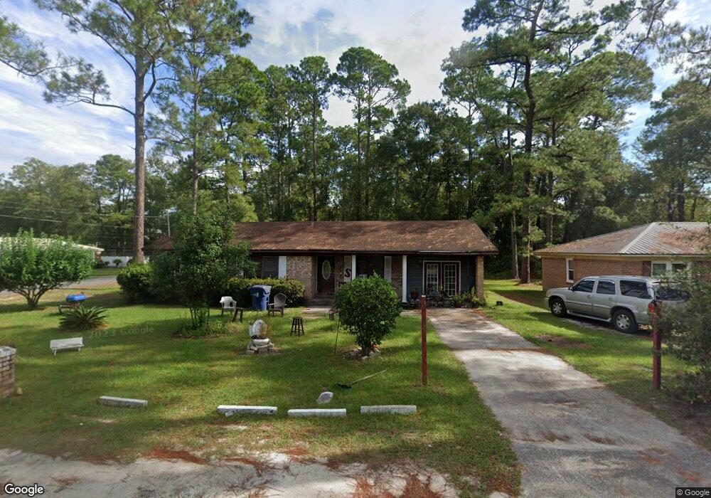
This home is located at 625 Fir St, Jesup, GA 31546 and is currently estimated at $109,698, approximately $74 per square foot. 625 Fir St is a home located in Wayne County with nearby schools including Jesup Elementary School, Arthur Williams Middle School, and Wayne County High School.
Ownership History
Date
Name
Owned For
Owner Type
Purchase Details
Closed on
Mar 3, 2022
Sold by
Veale Nancy
Bought by
Doomes Quartez
Current Estimated Value
Purchase Details
Closed on
Mar 2, 2022
Sold by
Rooks Arthur
Bought by
Veale Nancy
Purchase Details
Closed on
Dec 21, 2005
Sold by
Rooks Arthur
Bought by
Rooks Bertha and Rooks Arthur
Home Financials for this Owner
Home Financials are based on the most recent Mortgage that was taken out on this home.
Original Mortgage
$59,925
Interest Rate
6.19%
Mortgage Type
New Conventional
Purchase Details
Closed on
Sep 1, 2002
Bought by
Rooks Arthur
Purchase Details
Closed on
Dec 1, 1995
Purchase Details
Closed on
Dec 1, 1989
Purchase Details
Closed on
Feb 1, 1979
Purchase Details
Closed on
Sep 1, 1976
Create a Home Valuation Report for This Property
The Home Valuation Report is an in-depth analysis detailing your home's value as well as a comparison with similar homes in the area
Home Values in the Area
Average Home Value in this Area
Purchase History
| Date | Buyer | Sale Price | Title Company |
|---|---|---|---|
| Doomes Quartez | $68,000 | -- | |
| Veale Nancy | -- | -- | |
| Veale Nancy | -- | -- | |
| Rooks Bertha | $59,925 | -- | |
| Rooks Arthur | $35,000 | -- | |
| -- | -- | -- | |
| -- | $36,000 | -- | |
| -- | $3,700 | -- | |
| -- | -- | -- |
Source: Public Records
Mortgage History
| Date | Status | Borrower | Loan Amount |
|---|---|---|---|
| Previous Owner | Rooks Bertha | $59,925 |
Source: Public Records
Tax History Compared to Growth
Tax History
| Year | Tax Paid | Tax Assessment Tax Assessment Total Assessment is a certain percentage of the fair market value that is determined by local assessors to be the total taxable value of land and additions on the property. | Land | Improvement |
|---|---|---|---|---|
| 2024 | $1,229 | $40,182 | $1,536 | $38,646 |
| 2023 | $994 | $28,089 | $1,536 | $26,553 |
| 2022 | $884 | $28,089 | $1,536 | $26,553 |
| 2021 | $947 | $28,089 | $1,536 | $26,553 |
| 2020 | $980 | $28,089 | $1,536 | $26,553 |
| 2019 | $1,009 | $28,089 | $1,536 | $26,553 |
| 2018 | $1,009 | $28,089 | $1,536 | $26,553 |
| 2017 | $869 | $28,089 | $1,536 | $26,553 |
| 2016 | $841 | $28,089 | $1,536 | $26,553 |
| 2014 | $843 | $28,089 | $1,536 | $26,553 |
| 2013 | -- | $28,088 | $1,536 | $26,552 |
Source: Public Records
Map
Nearby Homes
- 548 N Cypress St
- 455 N Mahogany St
- 0 E Oak St
- Apt E Oak St
- 385 N Hickory St
- 447 NE Broad St
- 498 NE Broad St
- 436-441 Brunswick St
- 249 Pine Ridge Rd
- 658 E Walnut St
- 217 E Pine St
- 217 Pine Ridge Rd
- 207 E Pine St
- 197 NW Broad St
- 111 N Mahogany St
- 301 U S 301
- 661 E Plum St
- 196 Pine Ridge Dr
- 774 E Plum St
- 0 N 4th St