
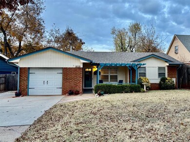
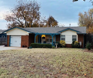

625 Reynolds Rd Edmond, OK 73013
Henderson Hills-Willow Creek NeighborhoodEstimated payment $1,099/month
Highlights
- Ranch Style House
- Covered Patio or Porch
- Utility Room in Garage
- Orvis Risner Elementary School Rated A
- Workshop
- Separate Outdoor Workshop
About This Home
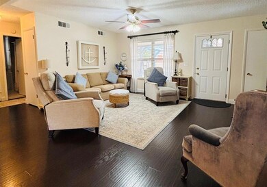
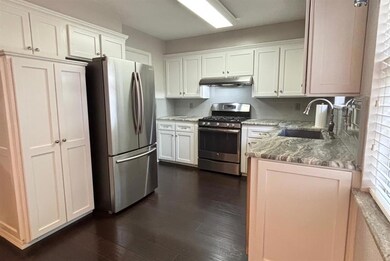
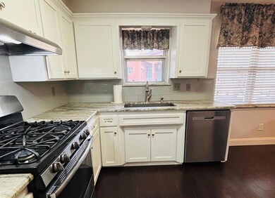
Open floorplan in the heart of Edmond. This two bedroom one bath home has a lot to offer. Property updates include, leathered granite kitchen countertops, shaker style cabinets, quartz bathroom vanity, updated laminate flooring, tile, and carpet. Covered front and back patios. New west side driveway. Large back yard 12x15 shed including workbench and shelving. Water heater 2024. Five burner stove/oven, HVAC 2014, dishwasher 2025, Roof 2021. Come see this cozy home today!
Home Details
Home Type
- Single Family
Est. Annual Taxes
- $1,224
Year Built
- Built in 1963
Lot Details
- 6,665 Sq Ft Lot
- South Facing Home
- Wood Fence
- Interior Lot
Parking
- 1 Car Attached Garage
- Driveway
Home Design
- Ranch Style House
- Traditional Architecture
- Brick Exterior Construction
- Slab Foundation
- Brick Frame
- Composition Roof
Interior Spaces
- 955 Sq Ft Home
- Workshop
- Utility Room in Garage
Kitchen
- Gas Oven
- Self-Cleaning Oven
- Gas Range
- Free-Standing Range
- Dishwasher
- Disposal
Flooring
- Carpet
- Laminate
- Tile
Bedrooms and Bathrooms
- 2 Bedrooms
- 1 Full Bathroom
Outdoor Features
- Covered Patio or Porch
- Separate Outdoor Workshop
Schools
- Angie Debo Elementary School
- Central Middle School
- Memorial High School
Utilities
- Central Heating and Cooling System
- Water Heater
Listing and Financial Details
- Legal Lot and Block 19 / 18
Map
Home Values in the Area
Average Home Value in this Area
Tax History
| Year | Tax Paid | Tax Assessment Tax Assessment Total Assessment is a certain percentage of the fair market value that is determined by local assessors to be the total taxable value of land and additions on the property. | Land | Improvement |
|---|---|---|---|---|
| 2024 | $1,224 | $13,122 | $1,878 | $11,244 |
| 2023 | $1,224 | $12,740 | $1,840 | $10,900 |
| 2022 | $1,190 | $12,368 | $2,113 | $10,255 |
| 2021 | $1,146 | $12,008 | $1,754 | $10,254 |
| 2020 | $1,124 | $11,659 | $1,867 | $9,792 |
| 2019 | $1,093 | $11,319 | $1,813 | $9,506 |
| 2018 | $1,065 | $10,991 | $0 | $0 |
| 2017 | $1,025 | $10,669 | $1,883 | $8,786 |
| 2016 | $1,000 | $10,449 | $1,883 | $8,566 |
| 2015 | $1,247 | $12,796 | $1,843 | $10,953 |
| 2014 | $1,206 | $12,422 | $1,883 | $10,539 |
Property History
| Date | Event | Price | List to Sale | Price per Sq Ft |
|---|---|---|---|---|
| 12/02/2025 12/02/25 | Pending | -- | -- | -- |
| 11/24/2025 11/24/25 | For Sale | $190,000 | -- | $199 / Sq Ft |
Purchase History
| Date | Type | Sale Price | Title Company |
|---|---|---|---|
| Warranty Deed | $90,000 | None Available | |
| Interfamily Deed Transfer | -- | American Guaranty Title Co | |
| Warranty Deed | $85,000 | American Guaranty Title Co | |
| Warranty Deed | $65,000 | American Guaranty Title Co |
Source: MLSOK
MLS Number: 1202743
APN: 182441095
Disclaimer: Certain information contained herein is derived from information provided by parties other than Homes.com. All information provided is deemed reliable, but is not guaranteed to be accurate and should be independently verified.
![]() IDX information is provided exclusively for personal, non-commercial use, and may not be used for any purpose other than to identify prospective properties consumers may be interested in purchasing.
IDX information is provided exclusively for personal, non-commercial use, and may not be used for any purpose other than to identify prospective properties consumers may be interested in purchasing.
Information is deemed reliable but not guaranteed.
This information is not verified for authenticity or accuracy, is not guaranteed and may not reflect all real estate activity in the market.
Copyright 2025 MLSOK, Inc. All rights reserved.
- 617 Redstone Ave
- 1800 Michael Dr
- 1715 Edgewood Dr
- 2004 Pine Oak Dr
- 1912 Hardy Dr
- 328 Sahoma Terrace
- 2908 S Rankin St
- 1208 Cedar Ridge Rd
- 0 182431020 Unit 1196468
- 323 E 14th St
- 1404 Mary Lee Ln
- 1305 Cedar Ridge Rd
- 1213 Woodview Ln
- 325 Tullahoma Dr
- 320 E 13th St
- 907 E 33rd St
- 1213 Pine Oak Dr
- 2421 Marshall Dr
- 1008 E 11th St
- 1013 East Dr
