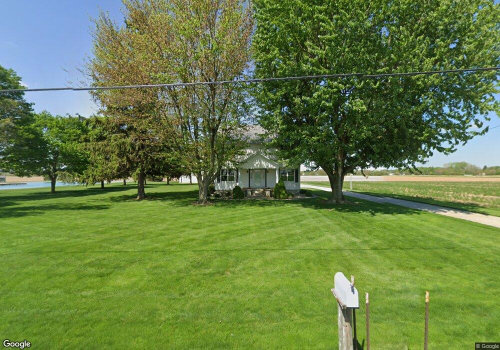
6261 Saint Marys Rd Delphos, OH 45833
Estimated Value: $217,000 - $266,000
4
Beds
2
Baths
2,321
Sq Ft
$107/Sq Ft
Est. Value
About This Home
This home is located at 6261 Saint Marys Rd, Delphos, OH 45833 and is currently estimated at $248,113, approximately $106 per square foot. 6261 Saint Marys Rd is a home located in Allen County with nearby schools including Delphos St. John's High School and Delphos St. John's Elementary School.
Ownership History
Date
Name
Owned For
Owner Type
Purchase Details
Closed on
Feb 4, 2019
Sold by
Noonan John A
Bought by
Noonan John A and The John A Noonan Revocable Tr
Current Estimated Value
Purchase Details
Closed on
Dec 12, 2018
Sold by
Noonan Paul R
Bought by
Noonan John A and Noonan Paula R
Purchase Details
Closed on
Mar 6, 1990
Bought by
Noonan Paula R
Create a Home Valuation Report for This Property
The Home Valuation Report is an in-depth analysis detailing your home's value as well as a comparison with similar homes in the area
Home Values in the Area
Average Home Value in this Area
Purchase History
| Date | Buyer | Sale Price | Title Company |
|---|---|---|---|
| Noonan John A | -- | None Available | |
| Noonan John A | -- | None Available | |
| Noonan Paula R | $70,000 | -- |
Source: Public Records
Tax History Compared to Growth
Tax History
| Year | Tax Paid | Tax Assessment Tax Assessment Total Assessment is a certain percentage of the fair market value that is determined by local assessors to be the total taxable value of land and additions on the property. | Land | Improvement |
|---|---|---|---|---|
| 2024 | $2,151 | $70,140 | $12,880 | $57,260 |
| 2023 | $1,774 | $54,360 | $9,980 | $44,380 |
| 2022 | $1,812 | $54,360 | $9,980 | $44,380 |
| 2021 | $1,821 | $54,360 | $9,980 | $44,380 |
| 2020 | $1,464 | $45,610 | $9,210 | $36,400 |
| 2019 | $1,464 | $45,610 | $9,210 | $36,400 |
| 2018 | $1,487 | $45,610 | $9,210 | $36,400 |
| 2017 | $1,362 | $42,290 | $9,210 | $33,080 |
| 2016 | $1,374 | $42,290 | $9,210 | $33,080 |
| 2015 | $1,227 | $42,290 | $9,210 | $33,080 |
| 2014 | $1,227 | $37,560 | $8,470 | $29,090 |
| 2013 | $1,232 | $37,560 | $8,470 | $29,090 |
Source: Public Records
Map
Nearby Homes
- 1001 S Adams St
- 827 S Washington St
- 227 W Clime St Unit 10
- 508 S Washington St
- 634 S Clay St
- 606 S Cass St
- 424 S Canal St
- 221 S Main St
- 633 E 2nd St
- 7110 Elida Rd
- 210 E 3rd St
- 821 E 3rd St
- 903 E 3rd St
- 405 N Franklin St
- 914 E 3rd St
- 409 N Bredeick St
- 610 N Washington St
- 650 E 6th St
- 628 N Pierce St
- 616 W 5th St
- 6187 Saint Marys Rd
- 6230 Saint Marys Rd
- 6200 Saint Marys Rd
- 6170 Saint Marys Rd
- XXX N Street Marys Rd
- 1200 Spencerville Rd
- 1134 Spencerville Rd
- 1005 S Adams St
- 1012 Spencerville Rd
- 1003 S Adams St
- 5925 N Street Marys Rd
- 5925 Saint Marys Rd
- 12453 S Clay Rd
- 12453 S Clay St
- 1002 Spencerville Rd
- 1000 S Adams St