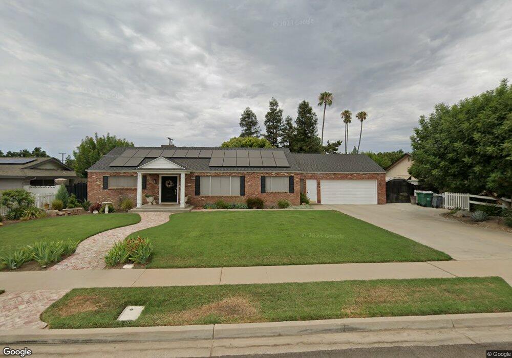
6266 E Townsend Ave Fresno, CA 93727
Sunnyside NeighborhoodEstimated Value: $365,000 - $482,000
3
Beds
2
Baths
1,921
Sq Ft
$227/Sq Ft
Est. Value
About This Home
This home is located at 6266 E Townsend Ave, Fresno, CA 93727 and is currently estimated at $436,781, approximately $227 per square foot. 6266 E Townsend Ave is a home located in Fresno County with nearby schools including John S. Wash Elementary School, Washington Academic Middle School, and Sanger High School.
Ownership History
Date
Name
Owned For
Owner Type
Purchase Details
Closed on
Jul 14, 2010
Sold by
Madrigal Rebecca
Bought by
Madrigal Rebecca
Current Estimated Value
Purchase Details
Closed on
Oct 12, 1998
Sold by
Brooks Donald K and Brooks Eleanore C
Bought by
Madrigal Rebecca
Home Financials for this Owner
Home Financials are based on the most recent Mortgage that was taken out on this home.
Original Mortgage
$90,000
Outstanding Balance
$19,195
Interest Rate
6.6%
Estimated Equity
$417,586
Create a Home Valuation Report for This Property
The Home Valuation Report is an in-depth analysis detailing your home's value as well as a comparison with similar homes in the area
Home Values in the Area
Average Home Value in this Area
Purchase History
| Date | Buyer | Sale Price | Title Company |
|---|---|---|---|
| Madrigal Rebecca | -- | None Available | |
| Madrigal Rebecca | $112,500 | Stewart Title | |
| Madrigal Rebecca | -- | Stewart Title |
Source: Public Records
Mortgage History
| Date | Status | Borrower | Loan Amount |
|---|---|---|---|
| Open | Madrigal Rebecca | $90,000 |
Source: Public Records
Tax History
| Year | Tax Paid | Tax Assessment Tax Assessment Total Assessment is a certain percentage of the fair market value that is determined by local assessors to be the total taxable value of land and additions on the property. | Land | Improvement |
|---|---|---|---|---|
| 2025 | $2,300 | $188,163 | $54,857 | $133,306 |
| 2023 | $2,150 | $180,859 | $52,728 | $128,131 |
| 2022 | $2,116 | $177,314 | $51,695 | $125,619 |
| 2021 | $2,097 | $173,838 | $50,682 | $123,156 |
| 2020 | $2,035 | $172,057 | $50,163 | $121,894 |
| 2019 | $1,992 | $168,684 | $49,180 | $119,504 |
| 2018 | $1,908 | $165,377 | $48,216 | $117,161 |
| 2017 | $1,874 | $162,135 | $47,271 | $114,864 |
| 2016 | $1,759 | $158,957 | $46,345 | $112,612 |
| 2015 | $1,773 | $156,570 | $45,649 | $110,921 |
| 2014 | $1,747 | $153,504 | $44,755 | $108,749 |
Source: Public Records
Map
Nearby Homes
- 6035 E Lyell Ave
- 6349 E Braly Ave
- 6591 E Liberty Ave
- 6310 E Woodward Ave
- 6525 E Raco Ave
- 6654 E Liberty Ave
- 6623 E Alta Ave
- 6954 E Braly Ave
- 5912 E Hamilton Ave
- 5890 E Dwight Way
- 5867 E Club View Dr
- 925 S Purdue Ave
- 944 S Clover Ave
- 6928 E Lane Ave
- 5795 E Butler Ave
- 5986 E Pitt Ave
- 1112 S Sunnyside Ave
- 5869 E Mono St
- 7176 E Butler Ave
- 5922 E Fancher Creek Dr
- 6284 E Townsend Ave
- 6250 E Townsend Ave
- 6267 E Butler Ave
- 6251 E Butler Ave
- 6285 E Butler Ave
- 6306 E Townsend Ave
- 6265 E Townsend Ave
- 6283 E Townsend Ave
- 6249 E Townsend Ave
- 6309 E Butler Ave
- 6222 E Townsend Ave
- 6303 E Townsend Ave
- 6322 E Townsend Ave
- 6223 E Butler Ave
- 6221 E Townsend Ave
- 6319 E Townsend Ave
- 6280 E Butler Ave
- 6325 E Butler Ave
- 6262 E Butler Ave
- 6300 E Butler Ave
Your Personal Tour Guide
Ask me questions while you tour the home.