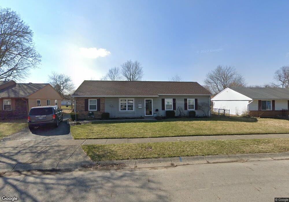
627 Spinning Rd New Carlisle, OH 45344
Estimated Value: $135,000 - $194,511
3
Beds
1
Bath
1,300
Sq Ft
$133/Sq Ft
Est. Value
About This Home
This home is located at 627 Spinning Rd, New Carlisle, OH 45344 and is currently estimated at $172,878, approximately $132 per square foot. 627 Spinning Rd is a home located in Clark County with nearby schools including New Carlisle Elementary School, Park Layne Elementary School, and Donnelsville Elementary School.
Ownership History
Date
Name
Owned For
Owner Type
Purchase Details
Closed on
Feb 13, 2002
Sold by
Massie Byron Kent
Bought by
Dean Joseph C
Current Estimated Value
Home Financials for this Owner
Home Financials are based on the most recent Mortgage that was taken out on this home.
Original Mortgage
$85,163
Outstanding Balance
$35,637
Interest Rate
7.23%
Mortgage Type
FHA
Estimated Equity
$137,241
Purchase Details
Closed on
Jan 4, 2002
Sold by
Wood Thomas W
Bought by
Massie Byron Kent
Home Financials for this Owner
Home Financials are based on the most recent Mortgage that was taken out on this home.
Original Mortgage
$85,163
Outstanding Balance
$35,637
Interest Rate
7.23%
Mortgage Type
FHA
Estimated Equity
$137,241
Create a Home Valuation Report for This Property
The Home Valuation Report is an in-depth analysis detailing your home's value as well as a comparison with similar homes in the area
Home Values in the Area
Average Home Value in this Area
Purchase History
| Date | Buyer | Sale Price | Title Company |
|---|---|---|---|
| Dean Joseph C | $86,500 | -- | |
| Massie Byron Kent | $58,000 | -- |
Source: Public Records
Mortgage History
| Date | Status | Borrower | Loan Amount |
|---|---|---|---|
| Open | Dean Joseph C | $85,163 | |
| Closed | Massie Byron Kent | $60,400 |
Source: Public Records
Tax History Compared to Growth
Tax History
| Year | Tax Paid | Tax Assessment Tax Assessment Total Assessment is a certain percentage of the fair market value that is determined by local assessors to be the total taxable value of land and additions on the property. | Land | Improvement |
|---|---|---|---|---|
| 2024 | $1,940 | $38,570 | $8,690 | $29,880 |
| 2023 | $1,940 | $38,570 | $8,690 | $29,880 |
| 2022 | $1,943 | $38,570 | $8,690 | $29,880 |
| 2021 | $1,955 | $34,290 | $6,690 | $27,600 |
| 2020 | $1,960 | $34,290 | $6,690 | $27,600 |
| 2019 | $1,992 | $34,290 | $6,690 | $27,600 |
| 2018 | $1,652 | $26,430 | $6,820 | $19,610 |
| 2017 | $1,539 | $29,383 | $6,822 | $22,561 |
| 2016 | $1,530 | $29,383 | $6,822 | $22,561 |
| 2015 | $1,513 | $28,858 | $6,689 | $22,169 |
| 2014 | $1,500 | $28,858 | $6,689 | $22,169 |
| 2013 | $1,503 | $28,858 | $6,689 | $22,169 |
Source: Public Records
Map
Nearby Homes
- 907 White Pine St
- 315 Fenwick Dr
- 222 Rawson Dr
- 1101 Cambridge Ct Unit 1103
- 225 Prentice Dr
- 224 Orth Dr
- 201 Monroe Way
- Palmetto Plan at Monroe Meadows
- Cooper Plan at Monroe Meadows
- Norway Plan at Monroe Meadows
- Chestnut Plan at Monroe Meadows
- Bradford Plan at Monroe Meadows
- Spruce Plan at Monroe Meadows
- Ironwood Plan at Monroe Meadows
- Ashton Plan at Monroe Meadows
- Aspen II Plan at Monroe Meadows
- Empress Plan at Monroe Meadows
- Walnut Plan at Monroe Meadows
- Juniper Plan at Monroe Meadows
- 202 Fenwick Dr
- 625 Spinning Rd
- 629 Spinning Rd
- 700 Willowick Dr
- 624 Willowick Dr
- 623 Spinning Rd
- 622 Willowick Dr
- 702 Willowick Dr
- 626 Spinning Dr
- 626 Spinning Rd
- 620 Willowick Dr
- 621 Spinning Rd
- 621 Spinning Dr
- 624 Spinning Rd
- 618 Willowick Dr
- 906 Pepperwood Dr
- 622 Spinning Rd
- 619 Spinning Rd
- 700 Applewood Dr
- 616 Willowick Dr
- 703 Willowick Dr