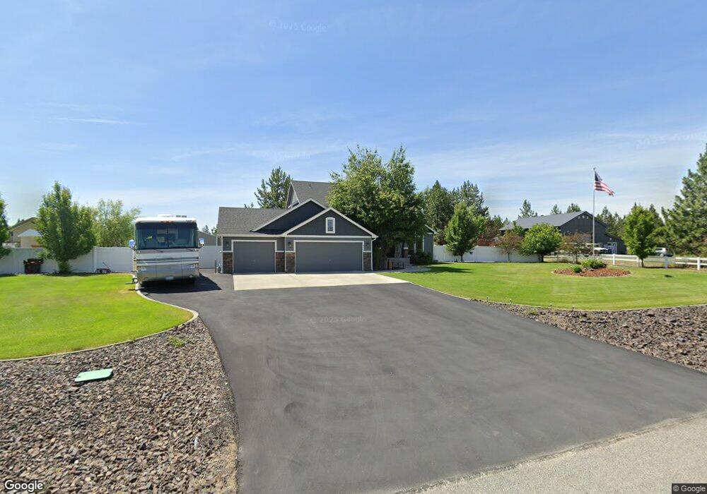
6275 Kassie Dr Nine Mile Falls, WA 99026
Estimated Value: $622,000 - $752,000
4
Beds
3
Baths
2,618
Sq Ft
$262/Sq Ft
Est. Value
About This Home
This home is located at 6275 Kassie Dr, Nine Mile Falls, WA 99026 and is currently estimated at $686,564, approximately $262 per square foot. 6275 Kassie Dr is a home located in Stevens County with nearby schools including Lakeside High School.
Ownership History
Date
Name
Owned For
Owner Type
Purchase Details
Closed on
Apr 7, 2009
Sold by
Lanzce G Douglass Inc
Bought by
Cassell Jeffrey C and Cassell Amber D
Current Estimated Value
Home Financials for this Owner
Home Financials are based on the most recent Mortgage that was taken out on this home.
Original Mortgage
$262,163
Outstanding Balance
$166,794
Interest Rate
5.06%
Mortgage Type
FHA
Estimated Equity
$519,770
Purchase Details
Closed on
Aug 1, 2007
Sold by
Ivar Industries Inc
Bought by
Lanzce G Douglass Inc
Create a Home Valuation Report for This Property
The Home Valuation Report is an in-depth analysis detailing your home's value as well as a comparison with similar homes in the area
Home Values in the Area
Average Home Value in this Area
Purchase History
| Date | Buyer | Sale Price | Title Company |
|---|---|---|---|
| Cassell Jeffrey C | -- | None Available | |
| Lanzce G Douglass Inc | $204,792 | Stevens County Title Company |
Source: Public Records
Mortgage History
| Date | Status | Borrower | Loan Amount |
|---|---|---|---|
| Open | Cassell Jeffrey C | $262,163 |
Source: Public Records
Tax History Compared to Growth
Tax History
| Year | Tax Paid | Tax Assessment Tax Assessment Total Assessment is a certain percentage of the fair market value that is determined by local assessors to be the total taxable value of land and additions on the property. | Land | Improvement |
|---|---|---|---|---|
| 2024 | $6,095 | $663,729 | $67,000 | $596,729 |
| 2023 | $5,847 | $660,126 | $67,000 | $593,126 |
| 2022 | $4,940 | $522,248 | $67,000 | $455,248 |
| 2021 | $3,815 | $392,383 | $37,000 | $355,383 |
| 2020 | $3,886 | $392,383 | $37,000 | $355,383 |
| 2019 | $3,657 | $331,433 | $37,000 | $294,433 |
| 2018 | $3,939 | $303,072 | $45,000 | $258,072 |
| 2017 | $3,632 | $304,046 | $45,000 | $259,046 |
| 2016 | $3,779 | $304,046 | $45,000 | $259,046 |
| 2015 | -- | $302,614 | $50,000 | $252,614 |
| 2013 | -- | $302,614 | $50,000 | $252,614 |
Source: Public Records
Map
Nearby Homes
- 6340 Jenna Ct
- 6263 Brennan Ct
- 5885 Sandy Court Way
- 6195 Khloe Ct
- 60849 Westview Dr
- XX Syringa
- 60829 Westview Dr
- 6282 W Bluebird Way
- 6265 W Bluebird Way
- 13228 W Sunnyvale Dr
- 6299 Sundown Rd
- 56xx W (Lot 4W) Jergens Rd Unit For GPS use 5629 Jer
- 16825 N Wylie Dr
- 5674B Jergens Rd
- 12719 W Greenfield Rd
- 6520 B Pine Ridge Way
- 6571 Kate Dr
- 6563 Kate Dr
- 6578 Kate Dr
- 6542 Kate Dr
- 6279 Kassie Dr
- 6271 Kassie Dr
- XXXX Kassie Dr
- 6274 Kassie Dr
- 6272 Kassie Dr
- 6263 Kassie Ct
- 6261 Pearson Dr
- 6263 Pearson Dr
- 6264 Kassie Ct
- 6287 Pearson Dr
- 6259 Pearson Dr
- 6261 Kassie Ct
- 6265 Pearson Dr
- 6286 Pearson Dr
- 6273 Jenna Dr
- 6260 Kassie Ct
- 6275 Jenna Dr
- 6288 Pearson Dr
- 6255 Pearson Dr
- 6262 Kassie Ct