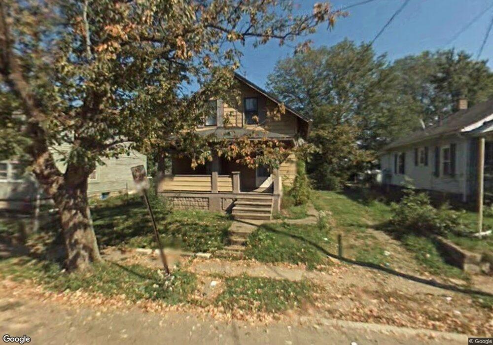
628 Johns Ave Mansfield, OH 44903
Estimated Value: $55,950 - $94,000
3
Beds
1
Bath
1,001
Sq Ft
$71/Sq Ft
Est. Value
About This Home
This home is located at 628 Johns Ave, Mansfield, OH 44903 and is currently estimated at $71,238, approximately $71 per square foot. 628 Johns Ave is a home located in Richland County with nearby schools including Foundation Academy, St. Peter's Elementary/Montessori School, and St. Peter's Junior High / High School.
Ownership History
Date
Name
Owned For
Owner Type
Purchase Details
Closed on
Sep 24, 2018
Sold by
Mitchell Renatha Ray and Ray Renatha Y
Bought by
D B Cooper Holdings Llc
Current Estimated Value
Purchase Details
Closed on
Aug 31, 2001
Sold by
Mitchell Renatha R
Bought by
Black Rose M
Create a Home Valuation Report for This Property
The Home Valuation Report is an in-depth analysis detailing your home's value as well as a comparison with similar homes in the area
Home Values in the Area
Average Home Value in this Area
Purchase History
| Date | Buyer | Sale Price | Title Company |
|---|---|---|---|
| D B Cooper Holdings Llc | $11,000 | Southern Title | |
| Black Rose M | $22,500 | -- |
Source: Public Records
Mortgage History
| Date | Status | Borrower | Loan Amount |
|---|---|---|---|
| Closed | Black Rose M | $0 |
Source: Public Records
Tax History
| Year | Tax Paid | Tax Assessment Tax Assessment Total Assessment is a certain percentage of the fair market value that is determined by local assessors to be the total taxable value of land and additions on the property. | Land | Improvement |
|---|---|---|---|---|
| 2024 | $223 | $4,870 | $1,510 | $3,360 |
| 2023 | $228 | $4,870 | $1,510 | $3,360 |
| 2022 | $216 | $3,870 | $1,380 | $2,490 |
| 2021 | $218 | $3,870 | $1,380 | $2,490 |
| 2020 | $223 | $3,870 | $1,380 | $2,490 |
| 2019 | $247 | $3,870 | $1,380 | $2,490 |
| 2018 | $243 | $3,870 | $1,380 | $2,490 |
| 2017 | $512 | $8,160 | $1,380 | $6,780 |
| 2016 | $525 | $8,320 | $2,180 | $6,140 |
| 2015 | $502 | $8,320 | $2,180 | $6,140 |
| 2014 | $495 | $8,320 | $2,180 | $6,140 |
| 2012 | $188 | $8,310 | $2,290 | $6,020 |
Source: Public Records
Map
Nearby Homes
- 0 Grant Rd Unit 5190994
- 524 Lida St
- 118 Raymond Ave
- 580 N Mulberry St
- 701 Springmill St
- 0 Voegele Ave Unit Lot 6048, 6049, 6
- 516 Burns St
- 572 France St
- 368 W 6th St
- 492 Stark St
- 0 State Route 314 Unit 9069650
- 688 Mcpherson St
- 212 Penn Ave
- 344 W 5th St
- 739 Armstrong St
- 0 Lemley Ave Unit 9070540
- 230 Rae Ave
- 10 Gray Ct
- 81 Penn Ave
- 799 Mcpherson St
Your Personal Tour Guide
Ask me questions while you tour the home.