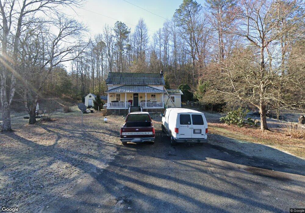
628 Robbins Rd Franklin, NC 28734
Estimated Value: $111,000
3
Beds
1
Bath
1,340
Sq Ft
$83/Sq Ft
Est. Value
About This Home
This home is located at 628 Robbins Rd, Franklin, NC 28734 and is currently priced at $111,000, approximately $82 per square foot. 628 Robbins Rd is a home located in Macon County with nearby schools including Iotla Valley Elementary School, Mountain View Intermediate School, and Macon Middle School.
Ownership History
Date
Name
Owned For
Owner Type
Purchase Details
Closed on
Jan 8, 2021
Sold by
Mainspring Conservation Trust Inc
Bought by
Historic Preservation Fndn Of Nc Inc
Current Estimated Value
Purchase Details
Closed on
Jan 4, 2021
Sold by
The Historicpreservation Fndn Of Nc Inc
Bought by
Pinkston John and Pinkston Jennifer
Purchase Details
Closed on
Apr 27, 2020
Sold by
Robbins Florence and Robbins Lawrence
Bought by
Mainspring Conservation Trust Inc
Purchase Details
Closed on
Jan 16, 2004
Sold by
Crescent Resources Inc
Bought by
Robbins, Lawrence Life Estate
Create a Home Valuation Report for This Property
The Home Valuation Report is an in-depth analysis detailing your home's value as well as a comparison with similar homes in the area
Home Values in the Area
Average Home Value in this Area
Purchase History
| Date | Buyer | Sale Price | Title Company |
|---|---|---|---|
| Historic Preservation Fndn Of Nc Inc | $34,000 | None Available | |
| Pinkston John | $50,000 | None Available | |
| Mainspring Conservation Trust Inc | -- | None Available | |
| Robbins, Lawrence Life Estate | -- | -- |
Source: Public Records
Tax History
| Year | Tax Paid | Tax Assessment Tax Assessment Total Assessment is a certain percentage of the fair market value that is determined by local assessors to be the total taxable value of land and additions on the property. | Land | Improvement |
|---|---|---|---|---|
| 2021 | $108 | $3,650 | $3,650 | $0 |
| 2020 | $267 | $33,060 | $3,650 | $29,410 |
| 2019 | $254 | $33,060 | $3,650 | $29,410 |
| 2018 | $192 | $21,600 | $1,680 | $19,920 |
| 2017 | $192 | $21,600 | $1,680 | $19,920 |
| 2016 | $189 | $21,600 | $1,680 | $19,920 |
| 2015 | $166 | $21,600 | $1,680 | $19,920 |
| 2014 | $149 | $22,140 | $5,700 | $16,440 |
| 2013 | -- | $22,140 | $5,700 | $16,440 |
Source: Public Records
Map
Nearby Homes
- 43 Moon Shadow Rd
- 371 McCoy Hill Rd
- Lot 6 Jay Bird Trail
- Lot 5 Jay Bird Trail
- 4908 Rose Creek Rd
- 681 Bradley Rd
- 4136 Rose Creek Rd
- 0 Bradley Creek Rd Unit 26042870
- 0 Bradley Creek Rd Unit 26041164
- 0 Bradley Creek Rd Unit 26046509
- 00 Judds Trail
- 4092 Rose Creek Rd
- 8567 Lower Burningtown Rd
- 6103539 Boulder Ct
- 39 & 27 Woodcove Dr
- 651 Hidden Acres Trail
- Lot 1 Hidden Acres Trail
- 288 Deer Path Trail
- 3540 Rose Creek Rd
- 22 N Moss Way
- 82 Woodchuck Ln
- 63 Woodchuck Ln
- 39 Woodchuck Ln
- 864 Robbins Rd
- 19 Woodchuck Ln
- 1 Woodchuck Ln
- 10190 Bryson City Rd
- 2 Woodchuck Ln
- 9778 Bryson City Rd
- 390 Oak Grove Church Rd
- 9835 Bryson City Rd
- 960 Robbins Rd
- 860 Robbins Rd
- 297 West Rd
- 277 West Rd
- 9768 Bryson City Rd
- 879 Robbins Rd
- 28 Lakey Creek Rd
- 1110 Robbins Rd
- 9709 Bryson City Rd
Your Personal Tour Guide
Ask me questions while you tour the home.