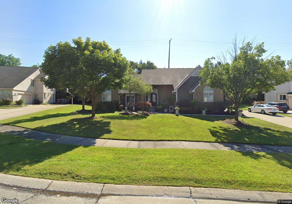
6283 Royal Pointe Dr West Bloomfield, MI 48322
Estimated Value: $553,731 - $712,000
4
Beds
3
Baths
3,667
Sq Ft
$175/Sq Ft
Est. Value
About This Home
This home is located at 6283 Royal Pointe Dr, West Bloomfield, MI 48322 and is currently estimated at $641,433, approximately $174 per square foot. 6283 Royal Pointe Dr is a home located in Oakland County with nearby schools including Sheiko Elementary School, West Bloomfield Middle School, and Bloomfield Maples Montessori.
Ownership History
Date
Name
Owned For
Owner Type
Purchase Details
Closed on
Aug 28, 2014
Sold by
Jpmorgan Chase Bank Na
Bought by
Thuwaini Haitham and Thuwaini Zeena
Current Estimated Value
Home Financials for this Owner
Home Financials are based on the most recent Mortgage that was taken out on this home.
Original Mortgage
$270,000
Interest Rate
4.15%
Mortgage Type
Stand Alone Refi Refinance Of Original Loan
Purchase Details
Closed on
Jun 22, 2010
Sold by
Thuwaini Haitham and Thuwaini Zeena
Bought by
Jpmorgan Chase Bank National Association
Purchase Details
Closed on
Aug 21, 1998
Sold by
Eisenshtadt James H
Bought by
Thuwaini Haitham
Home Financials for this Owner
Home Financials are based on the most recent Mortgage that was taken out on this home.
Original Mortgage
$259,000
Interest Rate
7.06%
Create a Home Valuation Report for This Property
The Home Valuation Report is an in-depth analysis detailing your home's value as well as a comparison with similar homes in the area
Home Values in the Area
Average Home Value in this Area
Purchase History
| Date | Buyer | Sale Price | Title Company |
|---|---|---|---|
| Thuwaini Haitham | $320,000 | None Available | |
| Jpmorgan Chase Bank National Association | $172,392 | None Available | |
| Thuwaini Haitham | $370,000 | -- |
Source: Public Records
Mortgage History
| Date | Status | Borrower | Loan Amount |
|---|---|---|---|
| Previous Owner | Thuwaini Haitham | $259,000 |
Source: Public Records
Tax History Compared to Growth
Tax History
| Year | Tax Paid | Tax Assessment Tax Assessment Total Assessment is a certain percentage of the fair market value that is determined by local assessors to be the total taxable value of land and additions on the property. | Land | Improvement |
|---|---|---|---|---|
| 2024 | $4,704 | $227,620 | $0 | $0 |
| 2022 | $4,499 | $186,820 | $25,630 | $161,190 |
| 2021 | $6,470 | $174,880 | $0 | $0 |
| 2020 | $4,136 | $176,250 | $25,630 | $150,620 |
| 2018 | $6,674 | $172,200 | $25,630 | $146,570 |
| 2015 | -- | $165,530 | $0 | $0 |
| 2014 | -- | $154,170 | $0 | $0 |
| 2011 | -- | $156,630 | $0 | $0 |
Source: Public Records
Map
Nearby Homes
- 5305 Wright Way S Unit 84
- 6250 Stonebridge W
- 6220 Andrea Ln Unit 40
- 6215 Andrea Ln
- 5200 Richard Run Unit 26
- 6422 Richard Run Unit 23
- 6207 Timberwood N
- 5216 Brett Ct Unit 53
- 5495 Kingsfield Dr
- 6684 Stonebridge E
- 6127 Wincliff Dr
- 5965 Crestwood Dr
- 6281 Potomac Cir
- 5049 Langlewood Dr
- 5493 S Piccadilly
- 6783 Burtonwood Dr
- 5835 Drake Rd
- 5015 Langlewood Dr
- 6607 Westbrooke Ct
- 5236 Patrick Rd
- 6301 Royal Pointe Dr
- 6265 Royal Pointe Dr
- 5521 Royal Wood
- 6319 Royal Pointe Dr
- 5504 Royal Wood
- 5520 Silver
- 5520 Silver Pond
- 5522 Royal Wood
- 5539 Royal Wood
- 6337 Royal Pointe Dr
- 5538 Silver Pond Unit Bldg-Unit
- 5538 Silver Pond
- 5540 Royal Wood
- 6196 Cromwell Rd
- 6216 Cromwell Rd
- 5557 Royal Wood
- 6346 Royal Pointe Dr
- 6355 Royal Pointe Dr
- 5556 Silver Pond
- 6253 Runnymead Ct