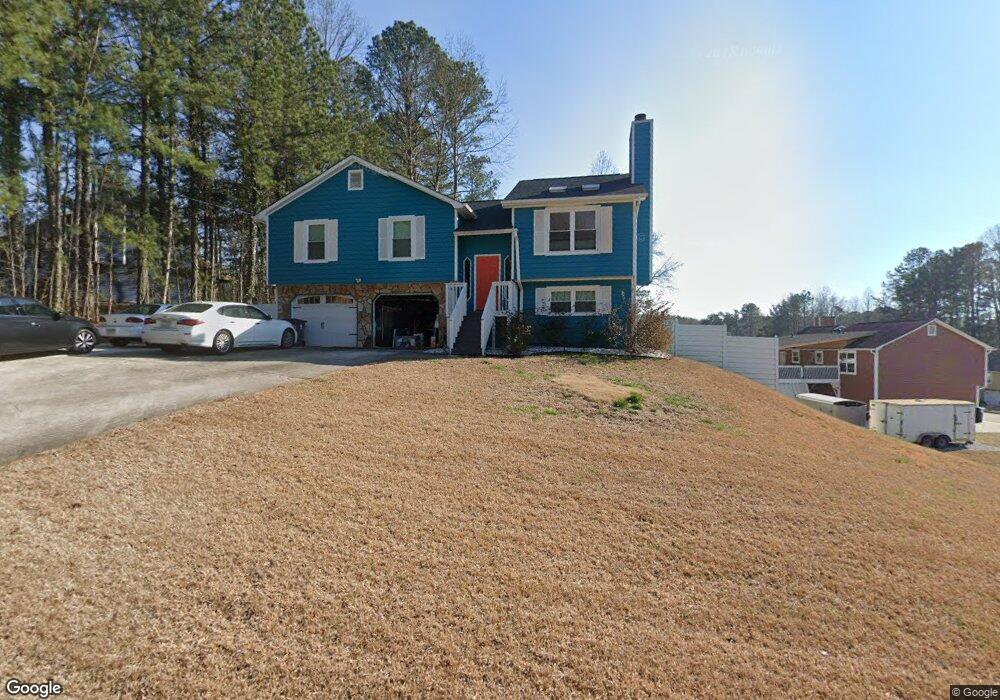
6285 Littleton Dr Union City, GA 30291
Estimated Value: $197,000 - $236,000
3
Beds
2
Baths
1,182
Sq Ft
$178/Sq Ft
Est. Value
About This Home
This home is located at 6285 Littleton Dr, Union City, GA 30291 and is currently estimated at $210,047, approximately $177 per square foot. 6285 Littleton Dr is a home located in Fulton County with nearby schools including Liberty Point Elementary School, Camp Creek Middle School, and Langston Hughes High School.
Ownership History
Date
Name
Owned For
Owner Type
Purchase Details
Closed on
Dec 24, 1998
Sold by
Zanders Mitchell D
Bought by
Jones Sonia D
Current Estimated Value
Home Financials for this Owner
Home Financials are based on the most recent Mortgage that was taken out on this home.
Original Mortgage
$86,000
Interest Rate
6.79%
Mortgage Type
New Conventional
Create a Home Valuation Report for This Property
The Home Valuation Report is an in-depth analysis detailing your home's value as well as a comparison with similar homes in the area
Home Values in the Area
Average Home Value in this Area
Purchase History
| Date | Buyer | Sale Price | Title Company |
|---|---|---|---|
| Jones Sonia D | $92,000 | -- |
Source: Public Records
Mortgage History
| Date | Status | Borrower | Loan Amount |
|---|---|---|---|
| Previous Owner | Jones Sonia D | $86,000 |
Source: Public Records
Tax History Compared to Growth
Tax History
| Year | Tax Paid | Tax Assessment Tax Assessment Total Assessment is a certain percentage of the fair market value that is determined by local assessors to be the total taxable value of land and additions on the property. | Land | Improvement |
|---|---|---|---|---|
| 2025 | $970 | $82,760 | $19,760 | $63,000 |
| 2023 | $1,582 | $56,040 | $11,080 | $44,960 |
| 2022 | $613 | $56,040 | $11,080 | $44,960 |
| 2021 | $463 | $37,400 | $7,720 | $29,680 |
| 2020 | $461 | $36,960 | $7,640 | $29,320 |
| 2019 | $784 | $27,960 | $5,760 | $22,200 |
| 2018 | $366 | $22,280 | $3,160 | $19,120 |
| 2017 | $382 | $22,280 | $3,160 | $19,120 |
| 2016 | $446 | $25,760 | $5,040 | $20,720 |
| 2015 | $851 | $25,760 | $5,040 | $20,720 |
| 2014 | $256 | $15,560 | $2,040 | $13,520 |
Source: Public Records
Map
Nearby Homes
- 6320 Littleton Dr
- 0 Highpoint Rd Unit 10553938
- 000 Highpoint Rd
- 99 Highpoint Rd
- 3227 Diamond Bluff
- 5135 Hilltop Dr
- 6030 Stonewall Dr
- 0 Lakeside Dr Unit 22475152
- 0 Lakeside Dr Unit 7515650
- 3426 Newgold Trace
- 5947 Rock Rd
- 6000 Diamond Ln
- 6024 Diamond Ln
- 4812 Station Dr Unit 2
- 4811 Station Dr Unit 35
- 9515 Lakeview Rd
- 4818 Sandstone Ln Unit 5
- 5910 Rock Rd
- 5856 Rock Rd
- 4817 Station Ln Unit 32
- 6295 Littleton Dr
- 6225 Littleton Dr
- 6215 Littleton Dr
- 6305 Littleton Dr
- 6290 Littleton Dr
- 6300 Littleton Dr
- 6280 Littleton Dr
- 6270 Littleton Dr
- 6205 Littleton Dr
- 6310 Littleton Dr Unit 2
- 6260 Littleton Dr
- 6220 Littleton Dr
- 6315 Littleton Dr
- 6315 Littleton Dr Unit 75
- 0 Littleton Dr Unit 9066031
- 6195 Littleton Dr Unit 2
- 6210 Littleton Dr
- 5530 Hillcrest Dr
- 5520 Hillcrest Dr
- 6240 Littleton Dr