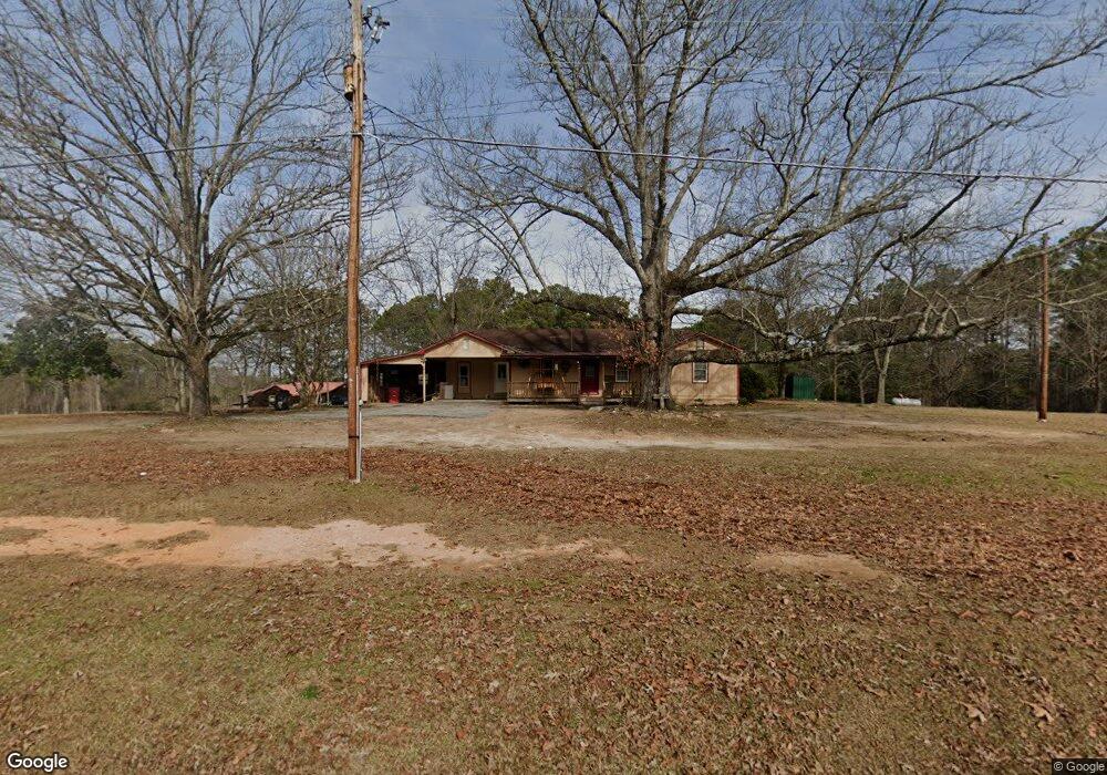
6289 Ridge Rd Appling, GA 30802
Estimated Value: $209,000 - $322,000
3
Beds
2
Baths
1,663
Sq Ft
$173/Sq Ft
Est. Value
About This Home
This home is located at 6289 Ridge Rd, Appling, GA 30802 and is currently estimated at $288,137, approximately $173 per square foot. 6289 Ridge Rd is a home located in Columbia County with nearby schools including North Columbia Elementary School, Harlem Middle School, and Suncoast Community High School.
Ownership History
Date
Name
Owned For
Owner Type
Purchase Details
Closed on
Jan 7, 2025
Sold by
Dew Land Development Co
Bought by
Cato Austin T and Olliff Morgan B
Current Estimated Value
Home Financials for this Owner
Home Financials are based on the most recent Mortgage that was taken out on this home.
Original Mortgage
$298,934
Outstanding Balance
$296,496
Interest Rate
6.6%
Mortgage Type
New Conventional
Estimated Equity
-$8,359
Purchase Details
Closed on
Mar 18, 2024
Sold by
Dew Land Development Co
Bought by
Poteet Heather A and Poteet Lewis Dean
Purchase Details
Closed on
Mar 4, 2024
Sold by
Jordan Patricia Danielle
Bought by
Dew Land Development Co
Purchase Details
Closed on
Nov 15, 2022
Sold by
Melson Hoyt Jack
Bought by
Melson Patricia Danielle
Purchase Details
Closed on
Sep 25, 2015
Sold by
Storey Anita C
Bought by
Melson Hoyt J and Melson Patricia D
Create a Home Valuation Report for This Property
The Home Valuation Report is an in-depth analysis detailing your home's value as well as a comparison with similar homes in the area
Home Values in the Area
Average Home Value in this Area
Purchase History
| Date | Buyer | Sale Price | Title Company |
|---|---|---|---|
| Cato Austin T | $304,449 | -- | |
| Poteet Heather A | $32,500 | -- | |
| Dew Land Development Co | $150,000 | -- | |
| Jordan Patricia Danielle | -- | -- | |
| Melson Patricia Danielle | -- | -- | |
| Melson Hoyt J | $74,400 | -- |
Source: Public Records
Mortgage History
| Date | Status | Borrower | Loan Amount |
|---|---|---|---|
| Open | Cato Austin T | $298,934 |
Source: Public Records
Tax History Compared to Growth
Tax History
| Year | Tax Paid | Tax Assessment Tax Assessment Total Assessment is a certain percentage of the fair market value that is determined by local assessors to be the total taxable value of land and additions on the property. | Land | Improvement |
|---|---|---|---|---|
| 2025 | $1,451 | $60,884 | $22,303 | $38,581 |
| 2024 | $1,386 | $55,512 | $22,727 | $32,785 |
| 2023 | $1,386 | $48,300 | $16,555 | $31,745 |
| 2022 | $1,251 | $48,173 | $16,555 | $31,618 |
| 2021 | $1,212 | $44,619 | $16,299 | $28,320 |
| 2020 | $1,208 | $43,549 | $16,043 | $27,506 |
| 2019 | $1,163 | $41,930 | $16,039 | $25,891 |
| 2018 | $1,156 | $41,518 | $16,291 | $25,227 |
| 2017 | $1,170 | $41,889 | $16,545 | $25,344 |
| 2016 | $802 | $29,760 | $11,408 | $18,352 |
Source: Public Records
Map
Nearby Homes
- 6275 Ridge Rd
- Lot 1-E Ridge Rd
- LOT B Ridge Rd
- LOT C Ridge Rd
- 4121 Pine Ridge Rd
- 6205 Keg Creek Dr
- 6312 Keg Creek Dr
- 6452 Washington Rd
- 6075 Stb3 Ridge Rd
- 0 Ridge Rd
- 6710 Washington Rd
- 3320 Ray Owens Rd
- 3316 Ray Owens Rd
- 3405 Tom Bartles Rd
- 3395 Tom Bartles Rd
- 3409 Tom Bartles Rd
- 945 Neptune Trail
- 935 Neptune Trail
- 905 Neptune Trail
- 6982 Moontown Dr E
- 6295 Ridge Rd
- 6286 Ridge Rd
- 6274 Ridge Rd
- 6293 Ridge Rd
- 6283 Ridge Rd
- 6272 Ridge Rd
- 6326 Ridge Rd
- 6271 Ridge Rd
- LOTS B&C Ridge Rd
- LOT 1 B&C Ridge Rd
- (TBD) 0 Ridge Rd
- 2342 Ridge Rd
- 2343 Ridge Rd
- 2437 Ridge Rd
- 2328 Ridge Rd
- 2336 Ridge Rd
- 2603 Ridge Rd
- 1-E Ridge Rd
- 6268 Ridge Rd
- 6240* Ridge Rd Unit / E09