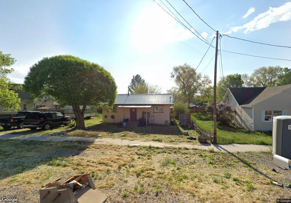
629 S 300 W Richfield, UT 84701
Estimated Value: $161,334 - $205,000
--
Bed
--
Bath
640
Sq Ft
$295/Sq Ft
Est. Value
About This Home
This home is located at 629 S 300 W, Richfield, UT 84701 and is currently estimated at $188,584, approximately $294 per square foot. 629 S 300 W is a home with nearby schools including Ashman School, Pahvant School, and Red Hills Middle School.
Ownership History
Date
Name
Owned For
Owner Type
Purchase Details
Closed on
Jun 14, 2007
Sold by
Allen Michael A
Bought by
Barney Wayda Robert
Current Estimated Value
Home Financials for this Owner
Home Financials are based on the most recent Mortgage that was taken out on this home.
Original Mortgage
$1,038
Outstanding Balance
$630
Interest Rate
6.21%
Mortgage Type
Stand Alone Second
Estimated Equity
$187,954
Create a Home Valuation Report for This Property
The Home Valuation Report is an in-depth analysis detailing your home's value as well as a comparison with similar homes in the area
Home Values in the Area
Average Home Value in this Area
Purchase History
| Date | Buyer | Sale Price | Title Company |
|---|---|---|---|
| Barney Wayda Robert | -- | First American Title |
Source: Public Records
Mortgage History
| Date | Status | Borrower | Loan Amount |
|---|---|---|---|
| Open | Barney Wayda Robert | $1,038 | |
| Open | Barney Wayda Robert | $64,000 |
Source: Public Records
Tax History Compared to Growth
Tax History
| Year | Tax Paid | Tax Assessment Tax Assessment Total Assessment is a certain percentage of the fair market value that is determined by local assessors to be the total taxable value of land and additions on the property. | Land | Improvement |
|---|---|---|---|---|
| 2024 | $750 | $77,734 | $30,766 | $46,968 |
| 2023 | $769 | $65,722 | $28,532 | $37,190 |
| 2022 | $613 | $55,951 | $23,583 | $32,368 |
| 2021 | $636 | $48,909 | $24,892 | $24,017 |
| 2020 | $653 | $48,819 | $17,820 | $30,999 |
| 2019 | $548 | $43,330 | $14,850 | $28,480 |
| 2018 | $555 | $39,300 | $14,850 | $24,450 |
| 2017 | $541 | $36,570 | $14,850 | $21,720 |
| 2016 | $296 | $33,260 | $0 | $0 |
| 2015 | $296 | $25,150 | $0 | $0 |
| 2014 | $296 | $23,930 | $0 | $0 |
Source: Public Records
Map
Nearby Homes
- 250 W 700 S
- 330 W 700 S
- 581 S 200 W
- 0 Parcel #1-7-73 Unit 25-261286
- 553 S 100 W Unit 304
- 553 S 100 W Unit 202
- 553 S 100 W Unit 204
- 553 S 100 W Unit 104
- 553 S 100 W Unit 103
- 553 S 100 W Unit 203
- 553 S 100 W Unit 101
- 153 W 800 S
- 73 W 500 S Unit 203
- 73 W 500 S Unit 101
- 73 W 500 S Unit 304
- 73 W 500 S Unit 202
- 73 W 500 S Unit 103
- 528 W 650 S
- 837 610 W
- 554 W 1000 S