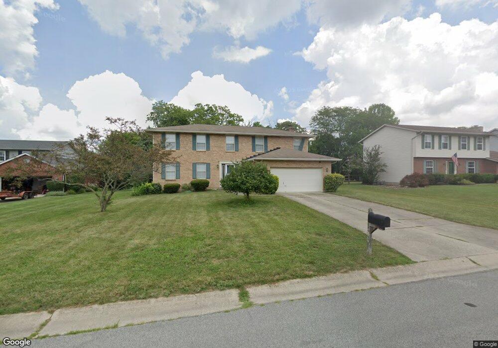
6297 Penny Ln Liberty Township, OH 45044
Estimated Value: $430,248 - $488,000
4
Beds
3
Baths
2,595
Sq Ft
$174/Sq Ft
Est. Value
About This Home
This home is located at 6297 Penny Ln, Liberty Township, OH 45044 and is currently estimated at $452,312, approximately $174 per square foot. 6297 Penny Ln is a home located in Butler County with nearby schools including Woodland Elementary School, Liberty Junior School, and Lakota East High School.
Ownership History
Date
Name
Owned For
Owner Type
Purchase Details
Closed on
Aug 22, 2022
Sold by
Davis Le and Adley Duong Adley
Bought by
Duong Adley
Current Estimated Value
Purchase Details
Closed on
Jan 27, 1998
Sold by
Sim Elizabeth O
Bought by
Le Davis
Home Financials for this Owner
Home Financials are based on the most recent Mortgage that was taken out on this home.
Original Mortgage
$15,000
Interest Rate
7.19%
Mortgage Type
Purchase Money Mortgage
Purchase Details
Closed on
Oct 26, 1994
Sold by
Stilin Neil
Bought by
Sim Elizabeth
Home Financials for this Owner
Home Financials are based on the most recent Mortgage that was taken out on this home.
Original Mortgage
$128,700
Interest Rate
8.68%
Mortgage Type
New Conventional
Purchase Details
Closed on
May 1, 1993
Create a Home Valuation Report for This Property
The Home Valuation Report is an in-depth analysis detailing your home's value as well as a comparison with similar homes in the area
Home Values in the Area
Average Home Value in this Area
Purchase History
| Date | Buyer | Sale Price | Title Company |
|---|---|---|---|
| Duong Adley | -- | None Listed On Document | |
| Le Davis | -- | First American Equity Loan S | |
| Sim Elizabeth | $143,000 | -- | |
| -- | $132,200 | -- |
Source: Public Records
Mortgage History
| Date | Status | Borrower | Loan Amount |
|---|---|---|---|
| Previous Owner | Le Davis | $15,000 | |
| Previous Owner | Sim Elizabeth | $128,700 |
Source: Public Records
Tax History Compared to Growth
Tax History
| Year | Tax Paid | Tax Assessment Tax Assessment Total Assessment is a certain percentage of the fair market value that is determined by local assessors to be the total taxable value of land and additions on the property. | Land | Improvement |
|---|---|---|---|---|
| 2024 | $4,525 | $114,500 | $14,940 | $99,560 |
| 2023 | $4,467 | $113,120 | $14,940 | $98,180 |
| 2022 | $3,943 | $79,070 | $14,940 | $64,130 |
| 2021 | $3,922 | $79,070 | $14,940 | $64,130 |
| 2020 | $4,021 | $79,070 | $14,940 | $64,130 |
| 2019 | $7,268 | $75,450 | $13,730 | $61,720 |
| 2018 | $4,285 | $75,450 | $13,730 | $61,720 |
| 2017 | $4,353 | $75,450 | $13,730 | $61,720 |
| 2016 | $3,909 | $67,360 | $13,730 | $53,630 |
| 2015 | $3,871 | $67,360 | $13,730 | $53,630 |
| 2014 | $3,818 | $67,360 | $13,730 | $53,630 |
| 2013 | $3,818 | $63,270 | $13,730 | $49,540 |
Source: Public Records
Map
Nearby Homes
- 6300 Lindsey Ct
- 7162 Wyandot Ln
- 7241 Stonebrook Ct
- 6816 Devon Dr
- 6919 Millikin Rd
- 7109 Maple Creek Dr
- 6951 Ash Creek Ct
- 6335 Gem Stone Dr
- 7232 Eaglestone Ct
- 7147 Wilhelmina Dr
- 5933 Old Pebble Path
- 7113 Shady Brook Bend
- 7120 Shady Brook Bend
- 5913 Stones Throw Way
- 7108 Shady Brook Bend
- 6828 Richards Dr
- 6691 Netherland Dr
- 6405 Cincinnati Dayton Rd
- 6512 Devon Dr
- 6226 Richards Dr