T
Seller's Agent in 2012
Tony Grossi
Coldwell Banker Realty - Sturbridge

Estimated Value: $235,799
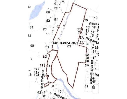
This land is esssentially landlocked. There is 250 feet of frontage on river Rd., old bridge is no longer in use. The timber on this woodlot will be thinned prior to sale. It is heavily wooded with ledge outcroppings and mature trees. Abutts the Army Corps of Engineers land and access road. Great private hunting/camping preserve.
Last Agent to Sell the Property
Tony Grossi
Coldwell Banker Realty - Sturbridge License #453012050 Listed on: 07/12/2011

Last Buyer's Agent
Tony Grossi
Coldwell Banker Realty - Sturbridge License #453012050 Listed on: 07/12/2011
| Date | Buyer | Sale Price | Title Company |
|---|---|---|---|
| Goodwin Edward T | $100,000 | -- | |
| Woodstock Properties | $60,000 | -- |
| Date | Status | Borrower | Loan Amount |
|---|---|---|---|
| Previous Owner | Woodstock Properties | $235,000 |
| Date | Event | Price | List to Sale | Price per Sq Ft |
|---|---|---|---|---|
| 01/14/2012 01/14/12 | Sold | $100,000 | -47.3% | -- |
| 12/15/2011 12/15/11 | Pending | -- | -- | -- |
| 07/12/2011 07/12/11 | For Sale | $189,900 | -- | -- |
| Year | Tax Paid | Tax Assessment Tax Assessment Total Assessment is a certain percentage of the fair market value that is determined by local assessors to be the total taxable value of land and additions on the property. | Land | Improvement |
|---|---|---|---|---|
| 2025 | $460 | $28,875 | $28,875 | $0 |
| 2024 | $463 | $28,075 | $28,075 | $0 |
| 2023 | $507 | $28,075 | $28,075 | $0 |
| 2022 | $538 | $28,075 | $28,075 | $0 |
| 2021 | $534 | $28,075 | $28,075 | $0 |
| 2020 | $534 | $28,075 | $28,075 | $0 |
| 2019 | $538 | $28,075 | $28,075 | $0 |
| 2018 | $546 | $28,075 | $28,075 | $0 |
| 2017 | $545 | $28,075 | $28,075 | $0 |
| 2016 | $539 | $28,075 | $28,075 | $0 |
| 2015 | $540 | $28,075 | $28,075 | $0 |
T
Seller's Agent in 2012
Tony Grossi
Coldwell Banker Realty - Sturbridge
Source: MLS Property Information Network (MLS PIN)
MLS Number: 71260440
APN: STUR-000340-000000-003824-000063
Disclaimer: Certain information contained herein is derived from information provided by parties other than Homes.com. All information provided is deemed reliable, but is not guaranteed to be accurate and should be independently verified.
![]() The property listing data and information, or the Images, set forth herein were provided to MLS Property Information Network, Inc. from third party sources, including sellers, lessors and public records, and were compiled by MLS Property Information Network, Inc. The property listing data and information, and the Images, are for the personal, non-commercial use of consumers having a good faith interest in purchasing or leasing listed properties of the type displayed to them and may not be used for any purpose other than to identify prospective properties which such consumers may have a good faith interest in purchasing or leasing. MLS Property Information Network, Inc. and its subscribers disclaim any and all representations and warranties as to the accuracy of the property listing data and information, or as to the accuracy of any of the Images, set forth herein.
The property listing data and information, or the Images, set forth herein were provided to MLS Property Information Network, Inc. from third party sources, including sellers, lessors and public records, and were compiled by MLS Property Information Network, Inc. The property listing data and information, and the Images, are for the personal, non-commercial use of consumers having a good faith interest in purchasing or leasing listed properties of the type displayed to them and may not be used for any purpose other than to identify prospective properties which such consumers may have a good faith interest in purchasing or leasing. MLS Property Information Network, Inc. and its subscribers disclaim any and all representations and warranties as to the accuracy of the property listing data and information, or as to the accuracy of any of the Images, set forth herein.
Ask me questions while you tour the home.