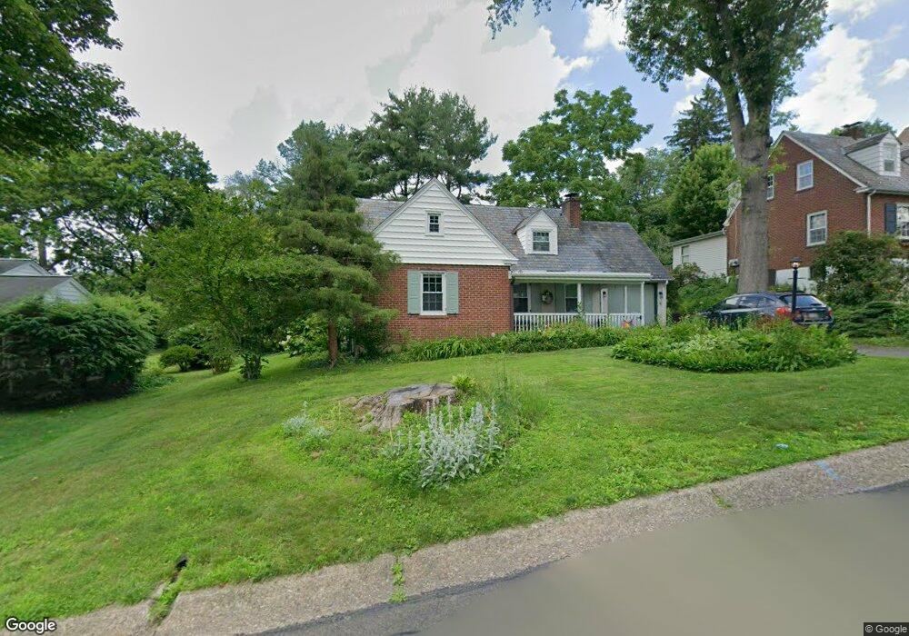
63 Meadow Ln Doylestown, PA 18901
Estimated Value: $725,000 - $818,000
3
Beds
3
Baths
1,983
Sq Ft
$388/Sq Ft
Est. Value
About This Home
This home is located at 63 Meadow Ln, Doylestown, PA 18901 and is currently estimated at $768,776, approximately $387 per square foot. 63 Meadow Ln is a home located in Bucks County with nearby schools including Linden El School, Lenape Middle School, and Central Bucks High School-West.
Ownership History
Date
Name
Owned For
Owner Type
Purchase Details
Closed on
Oct 30, 2024
Sold by
Camera Anita L
Bought by
Mccauley Patrick J and Block Suzanne J
Current Estimated Value
Home Financials for this Owner
Home Financials are based on the most recent Mortgage that was taken out on this home.
Original Mortgage
$475,000
Outstanding Balance
$470,236
Interest Rate
6.08%
Mortgage Type
New Conventional
Estimated Equity
$298,540
Purchase Details
Closed on
May 7, 1992
Sold by
Walker Rose L
Bought by
Camera Anita L
Purchase Details
Closed on
Sep 5, 1986
Bought by
Walker Rose L
Create a Home Valuation Report for This Property
The Home Valuation Report is an in-depth analysis detailing your home's value as well as a comparison with similar homes in the area
Home Values in the Area
Average Home Value in this Area
Purchase History
| Date | Buyer | Sale Price | Title Company |
|---|---|---|---|
| Mccauley Patrick J | $650,000 | My Title Pro | |
| Camera Anita L | $169,000 | -- | |
| Walker Rose L | $132,000 | -- |
Source: Public Records
Mortgage History
| Date | Status | Borrower | Loan Amount |
|---|---|---|---|
| Open | Mccauley Patrick J | $475,000 |
Source: Public Records
Tax History
| Year | Tax Paid | Tax Assessment Tax Assessment Total Assessment is a certain percentage of the fair market value that is determined by local assessors to be the total taxable value of land and additions on the property. | Land | Improvement |
|---|---|---|---|---|
| 2025 | $5,570 | $30,920 | $5,600 | $25,320 |
| 2024 | $5,570 | $30,920 | $5,600 | $25,320 |
| 2023 | $5,307 | $30,920 | $5,600 | $25,320 |
| 2022 | $5,233 | $30,920 | $5,600 | $25,320 |
| 2021 | $5,176 | $30,920 | $5,600 | $25,320 |
| 2020 | $5,119 | $30,920 | $5,600 | $25,320 |
| 2019 | $5,062 | $30,920 | $5,600 | $25,320 |
| 2018 | $5,001 | $30,920 | $5,600 | $25,320 |
| 2017 | $4,948 | $30,920 | $5,600 | $25,320 |
| 2016 | $4,948 | $30,920 | $5,600 | $25,320 |
| 2015 | -- | $30,920 | $5,600 | $25,320 |
| 2014 | -- | $30,920 | $5,600 | $25,320 |
Source: Public Records
Map
Nearby Homes
- 236 Green St
- 110 E Ashland St
- 69 E Oakland Ave
- 1 Steeplechase Dr
- 195 Lafayette St
- 146 E Court St
- 169 N Main St
- 150 Selner Ln
- 400 W Court St
- 78 Tower Hill Rd
- 102 Clear Springs Ct
- 215 N Franklin St
- 112 Steeplechase Dr
- 11-13 Aspen Way Unit 1113
- 9 Mill Creek Dr
- 2401 Lower State Rd Unit 102
- 9 Maple Ln
- 45 Springs Dr
- 34 Houk Rd
- 45 Latham Ct Unit 45
Your Personal Tour Guide
Ask me questions while you tour the home.