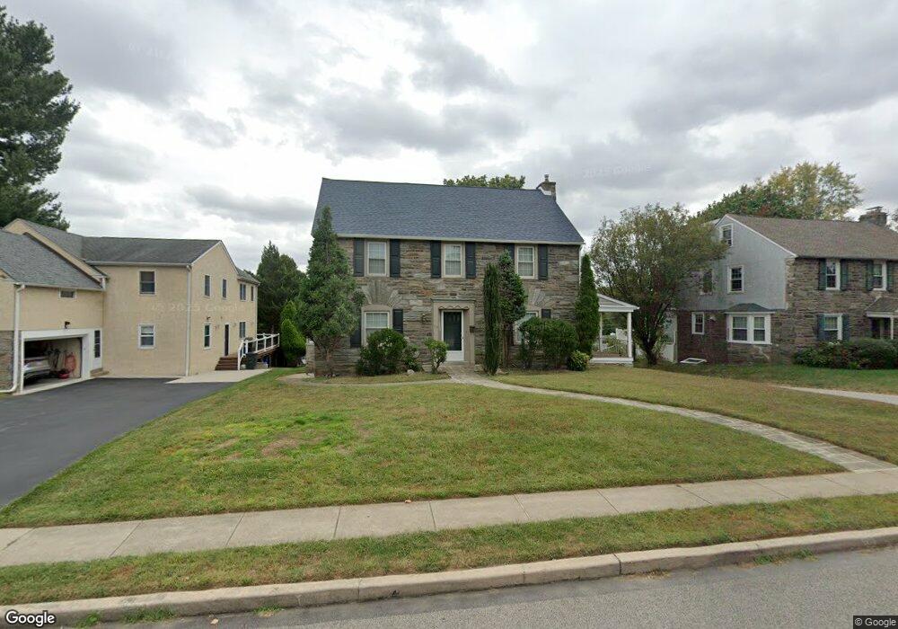
63 N New Ardmore Ave Broomall, PA 19008
Marple Township Delaware NeighborhoodEstimated Value: $783,880 - $925,000
5
Beds
3
Baths
2,974
Sq Ft
$279/Sq Ft
Est. Value
About This Home
This home is located at 63 N New Ardmore Ave, Broomall, PA 19008 and is currently estimated at $829,220, approximately $278 per square foot. 63 N New Ardmore Ave is a home located in Delaware County with nearby schools including Loomis Elementary School, Paxon Hollow Middle School, and Marple Newtown Senior High School.
Ownership History
Date
Name
Owned For
Owner Type
Purchase Details
Closed on
Mar 28, 2008
Sold by
Bruno Anthony S
Bought by
Singh Francis
Current Estimated Value
Home Financials for this Owner
Home Financials are based on the most recent Mortgage that was taken out on this home.
Original Mortgage
$417,000
Outstanding Balance
$261,245
Interest Rate
5.76%
Mortgage Type
Purchase Money Mortgage
Estimated Equity
$567,975
Purchase Details
Closed on
Sep 2, 2004
Sold by
Zahner Geraldine R
Bought by
Bruno Anthony S
Home Financials for this Owner
Home Financials are based on the most recent Mortgage that was taken out on this home.
Original Mortgage
$192,500
Interest Rate
6.08%
Mortgage Type
Fannie Mae Freddie Mac
Create a Home Valuation Report for This Property
The Home Valuation Report is an in-depth analysis detailing your home's value as well as a comparison with similar homes in the area
Home Values in the Area
Average Home Value in this Area
Purchase History
| Date | Buyer | Sale Price | Title Company |
|---|---|---|---|
| Singh Francis | $465,503 | Security Search & Abstract C | |
| Bruno Anthony S | $325,000 | -- |
Source: Public Records
Mortgage History
| Date | Status | Borrower | Loan Amount |
|---|---|---|---|
| Open | Singh Francis | $417,000 | |
| Previous Owner | Bruno Anthony S | $192,500 |
Source: Public Records
Tax History Compared to Growth
Tax History
| Year | Tax Paid | Tax Assessment Tax Assessment Total Assessment is a certain percentage of the fair market value that is determined by local assessors to be the total taxable value of land and additions on the property. | Land | Improvement |
|---|---|---|---|---|
| 2025 | $7,500 | $433,980 | $109,700 | $324,280 |
| 2024 | $7,500 | $433,980 | $109,700 | $324,280 |
| 2023 | $7,262 | $433,980 | $109,700 | $324,280 |
| 2022 | $7,124 | $433,980 | $109,700 | $324,280 |
| 2021 | $10,752 | $433,980 | $109,700 | $324,280 |
| 2020 | $5,830 | $202,580 | $55,980 | $146,600 |
| 2019 | $5,759 | $202,580 | $55,980 | $146,600 |
| 2018 | $5,700 | $202,580 | $0 | $0 |
| 2017 | $5,702 | $202,580 | $0 | $0 |
| 2016 | $1,112 | $202,580 | $0 | $0 |
| 2015 | $1,112 | $202,580 | $0 | $0 |
| 2014 | $1,112 | $202,580 | $0 | $0 |
Source: Public Records
Map
Nearby Homes
- 300 Rock Run Cir
- 54 Sterner Ave
- 1 Lawrence Rd Unit A3A
- 306 Rock Run Cir
- 1 Brighton Village Dr
- 63 S Greenhill Rd
- 7 Brighton Village Dr
- 15 Oakland Rd
- 88 4th Ave
- 127 Deerfield Rd
- 301 S New Ardmore Ave
- 200 Marple Rd
- 106 2nd Ave
- 1741 Lawrence Rd
- Lot1 Cynwyd
- Lot 2 Cynwyd
- 2025 S Sproul Rd
- 345 Ellis Rd
- 2604 Cynwyd Ave
- 126 1st Ave
- 57 N New Ardmore Ave
- 65 N New Ardmore Ave
- 22 Mather Ave
- 24 Mather Ave
- 51 N New Ardmore Ave
- 62 N New Ardmore Ave
- 20 Mather Ave
- 60 N New Ardmore Ave
- 2187 Anthony Ave
- 2204 Anthony Ave
- 58 N New Ardmore Ave
- 47 N New Ardmore Ave
- 18 Mather Ave
- 2201 Anthony Ave
- 56 N New Ardmore Ave
- 2185 Anthony Ave
- 2205 Anthony Ave
- 59 Ferguson Ave
- 61 Ferguson Ave
- 43 N New Ardmore Ave