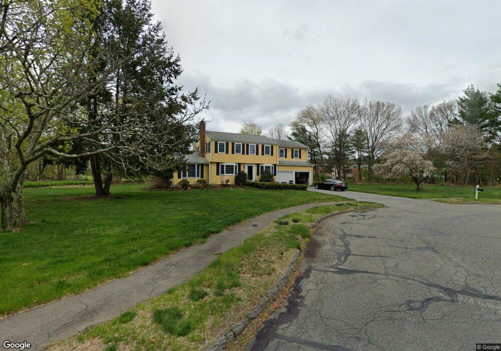
63 Raymond Rd Concord, MA 01742
Estimated Value: $1,227,008 - $1,493,000
4
Beds
3
Baths
2,223
Sq Ft
$599/Sq Ft
Est. Value
About This Home
This home is located at 63 Raymond Rd, Concord, MA 01742 and is currently estimated at $1,331,502, approximately $598 per square foot. 63 Raymond Rd is a home located in Middlesex County with nearby schools including Willard School, Concord Middle School, and Corwin-Russell School at Broccoli Hall.
Ownership History
Date
Name
Owned For
Owner Type
Purchase Details
Closed on
Jun 1, 1992
Sold by
Lambert Joseph J and Lambert Dorothy B
Bought by
Steele John J and Steele Carolie B
Current Estimated Value
Create a Home Valuation Report for This Property
The Home Valuation Report is an in-depth analysis detailing your home's value as well as a comparison with similar homes in the area
Home Values in the Area
Average Home Value in this Area
Purchase History
| Date | Buyer | Sale Price | Title Company |
|---|---|---|---|
| Steele John J | $250,000 | -- |
Source: Public Records
Mortgage History
| Date | Status | Borrower | Loan Amount |
|---|---|---|---|
| Open | Steele John J | $125,000 | |
| Open | Steele John J | $250,000 | |
| Closed | Steele John J | $157,500 |
Source: Public Records
Tax History Compared to Growth
Tax History
| Year | Tax Paid | Tax Assessment Tax Assessment Total Assessment is a certain percentage of the fair market value that is determined by local assessors to be the total taxable value of land and additions on the property. | Land | Improvement |
|---|---|---|---|---|
| 2025 | $144 | $1,086,200 | $611,300 | $474,900 |
| 2024 | $14,418 | $1,098,100 | $611,300 | $486,800 |
| 2023 | $13,554 | $1,045,800 | $582,200 | $463,600 |
| 2022 | $12,587 | $852,800 | $465,600 | $387,200 |
| 2021 | $12,287 | $834,700 | $465,600 | $369,100 |
| 2020 | $11,885 | $835,200 | $465,600 | $369,600 |
| 2019 | $11,265 | $793,900 | $452,200 | $341,700 |
| 2018 | $10,692 | $748,200 | $411,100 | $337,100 |
| 2017 | $10,645 | $756,600 | $419,500 | $337,100 |
| 2016 | $10,482 | $753,000 | $419,500 | $333,500 |
| 2015 | $9,547 | $668,100 | $362,600 | $305,500 |
Source: Public Records
Map
Nearby Homes
- 40 Rookery Ln Unit 5
- 72 Rookery Ln Unit 3
- 24 Rookery Ln Unit 6
- 56 Rookery Ln Unit 4
- 121 White Pond Way Unit 121
- 401 Emery Ln Unit 304
- 37 Wolf Pine Way
- 497 Old Road to 9 Acre Corner
- 42 Dakin Rd
- 49 Birchwood Ln Unit 49
- Lot 5 Sailaway Ln
- 45 N Crescent Cir
- Lot 4 Sailaway Ln
- 2 Betts Way
- 8 Mina Way
- 0 Elm Unit 73282184
- Lot 9 Sailaway Ln
- 4 Betts Way
- 122 Sand Gully Rd N Unit B
- 941 Concord Rd
- 72 Raymond Rd
- 66 Raymond Rd
- 44 Raymond Rd
- 35 Raymond Rd
- 30 Raymond Rd
- 19 Raymond Rd
- 19 Raymond Rd Unit 1
- 71 Alden Rd
- 151 Plainfield Rd
- 115 Plainfield Rd
- 49 Alden Rd
- 129 Plainfield Rd
- 97 Plainfield Rd
- 83 Alden Rd
- 169 Plainfield Rd
- 33 Alden Rd
- 81 Plainfield Rd
- 97 Alden Rd
- 97 Alden Rd Unit 1
- 69 Plainfield Rd