
Seller's Agent in 2025
Jason Maples
Grinnell Realty LLC
8 in this area
56 Total Sales

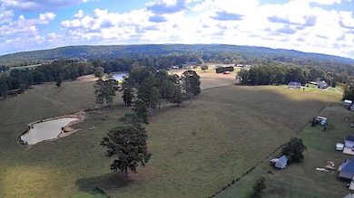
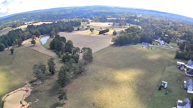
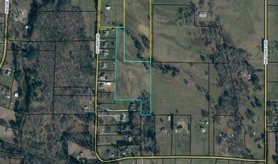
Endless possibilities await on this stunning 9.36-acre tract in Northwest Georgia! Zoned A-1, this open and level property offers a beautiful setting with wide views of the surrounding landscape. A surveyed and recorded easement is already in place, giving you peace of mind for access and future plans. Whether you're ready to build your dream home, create a small farm, or hold as an investment, this land provides the perfect canvas. With its combination of space, scenery, and convenience, you'll have room to design the lifestyle you've been dreaming of. Come take in the view and see why this property is the ideal place for your next chapter.
Last Agent to Sell the Property
Grinnell Realty LLC License #315424 Listed on: 10/01/2025
| Date | Type | Sale Price | Title Company |
|---|---|---|---|
| Limited Warranty Deed | $149,900 | -- | |
| Quit Claim Deed | -- | -- | |
| Deed | $66,700 | -- | |
| Deed | -- | -- | |
| Deed | -- | -- | |
| Deed | -- | -- |
| Date | Status | Loan Amount | Loan Type |
|---|---|---|---|
| Previous Owner | $176,000 | New Conventional |
| Date | Event | Price | List to Sale | Price per Sq Ft |
|---|---|---|---|---|
| 10/15/2025 10/15/25 | Sold | $149,900 | 0.0% | $80 / Sq Ft |
| 10/03/2025 10/03/25 | Pending | -- | -- | -- |
| 10/01/2025 10/01/25 | For Sale | $149,900 | -- | $80 / Sq Ft |
| Year | Tax Paid | Tax Assessment Tax Assessment Total Assessment is a certain percentage of the fair market value that is determined by local assessors to be the total taxable value of land and additions on the property. | Land | Improvement |
|---|---|---|---|---|
| 2025 | $143 | $23,512 | $23,512 | $0 |
| 2024 | $153 | $28,206 | $28,206 | $0 |
| 2023 | $152 | $22,386 | $22,386 | $0 |
| 2022 | $166 | $28,247 | $28,247 | $0 |
| 2021 | $178 | $28,247 | $28,247 | $0 |
| 2020 | $180 | $28,247 | $28,247 | $0 |
| 2019 | $178 | $28,247 | $28,247 | $0 |
| 2018 | $747 | $28,247 | $28,247 | $0 |
| 2017 | $1,986 | $88,211 | $41,346 | $46,865 |
| 2016 | $637 | $112,210 | $65,345 | $46,865 |
| 2015 | $1,336 | $97,229 | $56,250 | $40,979 |
| 2014 | $1,377 | $97,229 | $56,250 | $40,979 |
| 2013 | -- | $97,228 | $56,250 | $40,978 |
Seller's Agent in 2025
Jason Maples
Grinnell Realty LLC
8 in this area
56 Total Sales
Seller Co-Listing Agent in 2025
Pam Maples
Grinnell Realty LLC
(423) 421-2100
16 in this area
89 Total Sales
Buyer's Agent in 2025
Tracy Lee
Elite Realtors LLC
(423) 653-2960
9 in this area
125 Total Sales
Source: Greater Chattanooga REALTORS®
MLS Number: 1521446
APN: 0336-001
Disclaimer: Certain information contained herein is derived from information provided by parties other than Homes.com. All information provided is deemed reliable, but is not guaranteed to be accurate and should be independently verified.
![]() IDX information is provided exclusively for consumers’ personal, noncommercial use, that it may not be used for any purpose other than to identify prospective properties consumers may be interested in purchasing.
IDX information is provided exclusively for consumers’ personal, noncommercial use, that it may not be used for any purpose other than to identify prospective properties consumers may be interested in purchasing.
Data is deemed reliable but is not guaranteed accurate by the MLS.
Ten-X does not display the entire MLS of Chattanooga, Inc. database on this website. The listings of some real estate brokerage firms have been excluded. Some or all of the listings displayed may not belong to the firm whose website is being visited
Copyright© 2026 by Chattanooga Association of REALTORS®
Ask me questions while you tour the home.