
Seller's Agent in 2025
Rob Upchurch
RE/MAX
(706) 523-0014
599 Total Sales
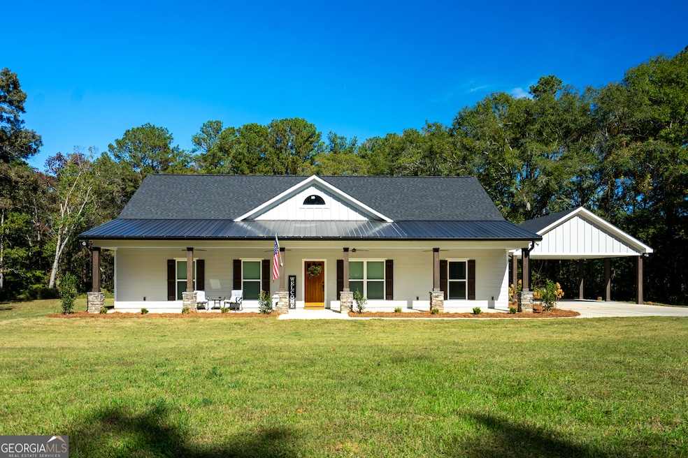
Discover your perfect retreat on twelve picturesque wooded acres in the highly sought-after Rosemont School District. This thoughtfully designed three-bedroom, two-and-a-half-bathroom home offers 2,119 square feet of comfortable living space surrounded by the tranquil beauty of large farms and pastoral landscapes. Step onto the spacious front porch and feel your stress melt away as you take in the serene wooded surroundings. The award-winning floor plan features gorgeous luxury vinyl plank flooring throughout and an open layout that seamlessly connects living spaces. The heart of the home showcases custom cabinetry paired with upgraded appliances, creating a kitchen that's both functional and beautiful. Nature enthusiasts will delight in the abundance of wildlife that calls this property home, making every morning coffee on the rear porch an adventure. The flexible room provides endless possibilities - whether you need a home office, playroom, or creative studio, this bonus space adapts to your lifestyle. Practical amenities include a convenient two-car carport for protected parking. The property's location offers the perfect balance of privacy and accessibility, with Callaway Gardens just a short drive away for outdoor recreation and family fun. This home represents exceptional quality construction in a setting that feels worlds away from the hustle and bustle, yet remains conveniently connected to community amenities. Whether you're watching deer graze in your backyard or entertaining friends on one of two inviting porches, this property offers a rare opportunity to embrace country living without sacrificing modern comforts and convenience. Call your Favorite Realtor Today to Learn More!
| Date | Type | Sale Price | Title Company |
|---|---|---|---|
| Warranty Deed | $455,000 | -- | |
| Quit Claim Deed | -- | -- | |
| Quit Claim Deed | -- | -- | |
| Deed | -- | -- | |
| Warranty Deed | $102,000 | -- | |
| Warranty Deed | -- | -- |
| Date | Status | Loan Amount | Loan Type |
|---|---|---|---|
| Open | $432,250 | Purchase Money Mortgage | |
| Previous Owner | $91,800 | New Conventional |
| Date | Event | Price | List to Sale | Price per Sq Ft |
|---|---|---|---|---|
| 12/12/2025 12/12/25 | Sold | $455,000 | -1.1% | $215 / Sq Ft |
| 10/31/2025 10/31/25 | Pending | -- | -- | -- |
| 10/27/2025 10/27/25 | For Sale | $459,900 | -- | $217 / Sq Ft |
| Year | Tax Paid | Tax Assessment Tax Assessment Total Assessment is a certain percentage of the fair market value that is determined by local assessors to be the total taxable value of land and additions on the property. | Land | Improvement |
|---|---|---|---|---|
| 2025 | $4,954 | $183,640 | $34,560 | $149,080 |
| 2024 | $943 | $34,560 | $34,560 | $0 |
| 2023 | $1,522 | $57,804 | $34,560 | $23,244 |
| 2022 | $1,357 | $50,604 | $28,800 | $21,804 |
| 2021 | $1,460 | $50,400 | $31,560 | $18,840 |
| 2020 | $1,460 | $50,400 | $31,560 | $18,840 |
| 2019 | $1,473 | $50,840 | $31,560 | $19,280 |
| 2018 | $1,420 | $49,084 | $31,560 | $17,524 |
| 2017 | $1,420 | $49,084 | $31,560 | $17,524 |
| 2016 | $1,413 | $48,850 | $31,585 | $17,265 |
| 2015 | $1,416 | $48,850 | $31,585 | $17,265 |
| 2014 | $1,391 | $47,942 | $31,585 | $16,356 |
| 2013 | -- | $48,971 | $31,585 | $17,386 |
Seller's Agent in 2025
Rob Upchurch
RE/MAX
(706) 523-0014
599 Total Sales
Buyer's Agent in 2025
Joel Upchurch
RE/MAX
(706) 523-1702
478 Total Sales
Source: Georgia MLS
MLS Number: 10632377
APN: 015-0-000-001F
Disclaimer: Certain information contained herein is derived from information provided by parties other than Homes.com. All information provided is deemed reliable, but is not guaranteed to be accurate and should be independently verified.
![]() The data relating to real estate for sale on this web site comes in part from the Broker Reciprocity Program of Georgia MLS. Real estate listings held by brokerage firms other than Redfin are marked with the Broker Reciprocity logo and detailed information about them includes the name of the listing brokers. Information deemed reliable but not guaranteed. Copyright 2026 Georgia MLS. All rights reserved.
The data relating to real estate for sale on this web site comes in part from the Broker Reciprocity Program of Georgia MLS. Real estate listings held by brokerage firms other than Redfin are marked with the Broker Reciprocity logo and detailed information about them includes the name of the listing brokers. Information deemed reliable but not guaranteed. Copyright 2026 Georgia MLS. All rights reserved.
Ask me questions while you tour the home.