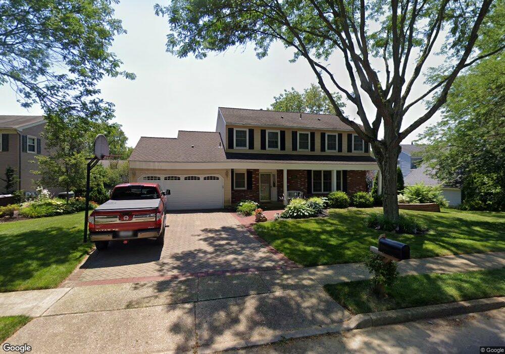
63 Waln Ln Langhorne, PA 19047
Estimated Value: $719,000 - $760,000
4
Beds
3
Baths
2,414
Sq Ft
$307/Sq Ft
Est. Value
About This Home
This home is located at 63 Waln Ln, Langhorne, PA 19047 and is currently estimated at $740,214, approximately $306 per square foot. 63 Waln Ln is a home located in Bucks County with nearby schools including Pearl S. Buck Elementary School, Maple Point Middle School, and Neshaminy High School.
Ownership History
Date
Name
Owned For
Owner Type
Purchase Details
Closed on
Sep 27, 2001
Sold by
Ellis Mark W and Ellis Sarah Luithle
Bought by
Mangiarelli Michael J and Mangiarelli Juliane M
Current Estimated Value
Home Financials for this Owner
Home Financials are based on the most recent Mortgage that was taken out on this home.
Original Mortgage
$227,600
Outstanding Balance
$89,091
Interest Rate
6.89%
Estimated Equity
$651,123
Purchase Details
Closed on
Mar 20, 1996
Sold by
Hyatt William L and Hyatt Brenda J
Bought by
Ellis Mark W and Ellis Sarah Luithle
Home Financials for this Owner
Home Financials are based on the most recent Mortgage that was taken out on this home.
Original Mortgage
$136,000
Interest Rate
7.39%
Create a Home Valuation Report for This Property
The Home Valuation Report is an in-depth analysis detailing your home's value as well as a comparison with similar homes in the area
Home Values in the Area
Average Home Value in this Area
Purchase History
| Date | Buyer | Sale Price | Title Company |
|---|---|---|---|
| Mangiarelli Michael J | $284,500 | Lawyers Title Insurance Corp | |
| Ellis Mark W | $184,300 | -- |
Source: Public Records
Mortgage History
| Date | Status | Borrower | Loan Amount |
|---|---|---|---|
| Open | Mangiarelli Michael J | $227,600 | |
| Previous Owner | Ellis Mark W | $136,000 |
Source: Public Records
Tax History
| Year | Tax Paid | Tax Assessment Tax Assessment Total Assessment is a certain percentage of the fair market value that is determined by local assessors to be the total taxable value of land and additions on the property. | Land | Improvement |
|---|---|---|---|---|
| 2025 | $7,994 | $36,720 | $6,000 | $30,720 |
| 2024 | $7,994 | $36,720 | $6,000 | $30,720 |
| 2023 | $7,867 | $36,720 | $6,000 | $30,720 |
| 2022 | $7,661 | $36,720 | $6,000 | $30,720 |
| 2021 | $7,661 | $36,720 | $6,000 | $30,720 |
| 2020 | $7,569 | $36,720 | $6,000 | $30,720 |
| 2019 | $7,400 | $36,720 | $6,000 | $30,720 |
| 2018 | $7,264 | $36,720 | $6,000 | $30,720 |
| 2017 | $7,079 | $36,720 | $6,000 | $30,720 |
| 2016 | $7,079 | $36,720 | $6,000 | $30,720 |
| 2015 | $7,268 | $36,720 | $6,000 | $30,720 |
| 2014 | $7,268 | $36,720 | $6,000 | $30,720 |
Source: Public Records
Map
Nearby Homes
- 443 Knollbrook Dr
- 680 Atkinson Ln
- 1004 Waterford Rd
- 1003 Waterford Rd Unit 158
- 11103 Cornerstone Dr Unit 21
- 3406 Sterling Rd Unit 123
- 1302 Waterford Rd Unit 8
- 7705 Spruce Mill Dr Unit 669
- 465 Cedar Hollow Dr Unit 153
- 20 Griffin Way
- 486 Cedar Hollow Dr Unit 46
- 195 Roosevelt Dr
- 24114 Hickory Ln
- 626A Palmer Ln Unit A
- 212 Shady Brook Dr Unit 283
- 350 Shady Brook Dr Unit 183
- 1613 Lakeview Cir
- 81 Lavender Dr
- 212 Clover Hill Ct
- 627 Bellflower Rd Unit V260
Your Personal Tour Guide
Ask me questions while you tour the home.