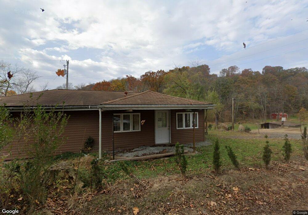
630 Browntown Rd New Stanton, PA 15672
Hempfield Township NeighborhoodEstimated Value: $134,665 - $270,000
--
Bed
--
Bath
1,270
Sq Ft
$160/Sq Ft
Est. Value
About This Home
This home is located at 630 Browntown Rd, New Stanton, PA 15672 and is currently estimated at $202,916, approximately $159 per square foot. 630 Browntown Rd is a home with nearby schools including Stanwood Elementary School, West Hempfield Middle School, and Hempfield Area Senior High School.
Ownership History
Date
Name
Owned For
Owner Type
Purchase Details
Closed on
Oct 17, 2006
Sold by
Proctor Eugene Richard and Proctor Mildred S
Bought by
Lazar Richard A
Current Estimated Value
Create a Home Valuation Report for This Property
The Home Valuation Report is an in-depth analysis detailing your home's value as well as a comparison with similar homes in the area
Home Values in the Area
Average Home Value in this Area
Purchase History
| Date | Buyer | Sale Price | Title Company |
|---|---|---|---|
| Lazar Richard A | $2,000 | None Available |
Source: Public Records
Tax History Compared to Growth
Tax History
| Year | Tax Paid | Tax Assessment Tax Assessment Total Assessment is a certain percentage of the fair market value that is determined by local assessors to be the total taxable value of land and additions on the property. | Land | Improvement |
|---|---|---|---|---|
| 2025 | $534 | $4,370 | $950 | $3,420 |
| 2024 | $512 | $4,370 | $950 | $3,420 |
| 2023 | $472 | $4,370 | $950 | $3,420 |
| 2022 | $472 | $4,370 | $950 | $3,420 |
| 2021 | $472 | $4,370 | $950 | $3,420 |
| 2020 | $472 | $4,370 | $950 | $3,420 |
| 2019 | $470 | $4,370 | $950 | $3,420 |
| 2018 | $464 | $4,370 | $950 | $3,420 |
| 2017 | $453 | $4,370 | $950 | $3,420 |
| 2016 | $431 | $4,370 | $950 | $3,420 |
| 2015 | $431 | $4,370 | $950 | $3,420 |
| 2014 | $424 | $4,370 | $950 | $3,420 |
Source: Public Records
Map
Nearby Homes
- 201 Madison Ave
- 620 Timberline Ln
- 124 Oak St
- 116 Karr Ln
- 182 Broadview Rd
- 205 Joseph Dr
- Penwell Plan at Broadview Estates
- Deerfield Plan at Broadview Estates
- Galen Plan at Broadview Estates
- Hamilton Plan at Broadview Estates
- 410 Curtis Ct
- 412 Curtis Ct
- 414 Curtis Ct
- 416 Curtis Ct
- 130 Keystone Rd
- 116 Dutchtown Rd
- 0 Broadview Rd
- 704 Madison Ave
- 233 Huntingdon Rd
- 156 Spring St
- 614 Browntown Rd
- 107 Yuma Ln
- 611 Browntown Rd
- 165 Keck Ln
- 109 Justice Ln
- 604 Browntown Rd
- 678 Browntown Rd
- 158 Keck Ln
- 674 Browntown Rd
- 599 Browntown Rd
- 683 Browntown Rd
- 140 Keck Ln
- 1108 Maughan Ln
- RR#1 Bx 290 Aka Brownstown Rd
- 1026 Waltz Mill Rd
- 128 Keck Ln
- 696 Browntown Rd
- 984 Waltz Mill Rd
- 1022 Waltz Mill Rd
- 64117 Lr