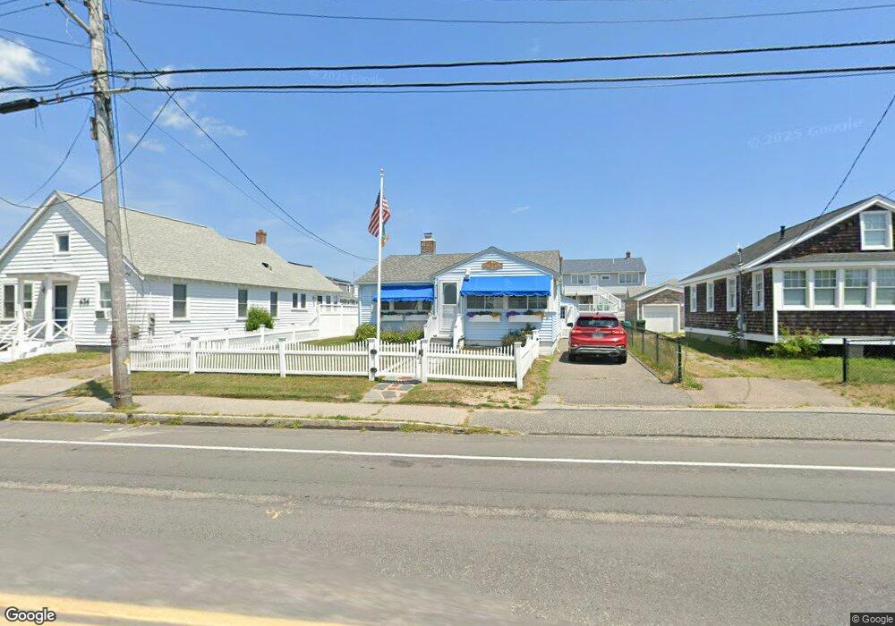
630 Ocean St Marshfield, MA 02050
Ocean Bluff-Brant Rock NeighborhoodEstimated Value: $604,000 - $670,000
2
Beds
1
Bath
858
Sq Ft
$732/Sq Ft
Est. Value
About This Home
This home is located at 630 Ocean St, Marshfield, MA 02050 and is currently estimated at $627,987, approximately $731 per square foot. 630 Ocean St is a home located in Plymouth County with nearby schools including Daniel Webster, Furnace Brook Middle School, and Marshfield High School.
Ownership History
Date
Name
Owned For
Owner Type
Purchase Details
Closed on
Sep 9, 2019
Sold by
Dillon John P and Dillon Anne
Bought by
Dillon Ft and Dillon
Current Estimated Value
Purchase Details
Closed on
Aug 16, 2001
Sold by
Kelly George T and Kelly Barbara A
Bought by
Dillon John P and Dillon Anne
Home Financials for this Owner
Home Financials are based on the most recent Mortgage that was taken out on this home.
Original Mortgage
$186,000
Interest Rate
7.16%
Mortgage Type
Purchase Money Mortgage
Purchase Details
Closed on
May 25, 1995
Sold by
Gep Rt
Bought by
Kelly George and Kelly Barbara
Create a Home Valuation Report for This Property
The Home Valuation Report is an in-depth analysis detailing your home's value as well as a comparison with similar homes in the area
Home Values in the Area
Average Home Value in this Area
Purchase History
| Date | Buyer | Sale Price | Title Company |
|---|---|---|---|
| Dillon Ft | -- | -- | |
| Dillon Ft | -- | -- | |
| Dillon John P | $201,000 | -- | |
| Dillon John P | $201,000 | -- | |
| Kelly George | $111,000 | -- | |
| Kelly George | $111,000 | -- |
Source: Public Records
Mortgage History
| Date | Status | Borrower | Loan Amount |
|---|---|---|---|
| Previous Owner | Kelly George | $220,000 | |
| Previous Owner | Kelly George | $40,000 | |
| Previous Owner | Kelly George | $186,000 |
Source: Public Records
Tax History
| Year | Tax Paid | Tax Assessment Tax Assessment Total Assessment is a certain percentage of the fair market value that is determined by local assessors to be the total taxable value of land and additions on the property. | Land | Improvement |
|---|---|---|---|---|
| 2025 | $5,357 | $541,100 | $377,800 | $163,300 |
| 2024 | $5,251 | $505,400 | $358,000 | $147,400 |
| 2023 | $4,710 | $445,900 | $310,200 | $135,700 |
| 2022 | $4,710 | $363,700 | $248,600 | $115,100 |
| 2021 | $4,689 | $355,500 | $248,600 | $106,900 |
| 2020 | $4,715 | $353,700 | $248,600 | $105,100 |
| 2019 | $4,599 | $343,700 | $248,600 | $95,100 |
| 2018 | $4,026 | $301,100 | $208,800 | $92,300 |
| 2017 | $4,067 | $296,400 | $208,800 | $87,600 |
| 2016 | $4,013 | $289,100 | $208,800 | $80,300 |
| 2015 | $3,637 | $273,700 | $198,900 | $74,800 |
| 2014 | $3,737 | $281,200 | $208,800 | $72,400 |
Source: Public Records
Map
Nearby Homes
- 626 Ocean St
- 634 Ocean St
- 69 Foster Ave
- 65 Foster Ave Unit 65
- 65 Foster Ave
- 65 Foster Ave Winter) Unit 65
- 622 Ocean St
- 21 Brook St
- 15 Brook St
- 640 Ocean St
- 61 Foster Ave
- 631 Ocean St
- 57 Foster Ave
- 627 Ocean St
- 623 Ocean St
- 614 Ocean St
- 53 Foster Ave
- 5 W Brook St
- 615 Ocean St
- 615 Ocean St (2016 Summer Rental)
Your Personal Tour Guide
Ask me questions while you tour the home.