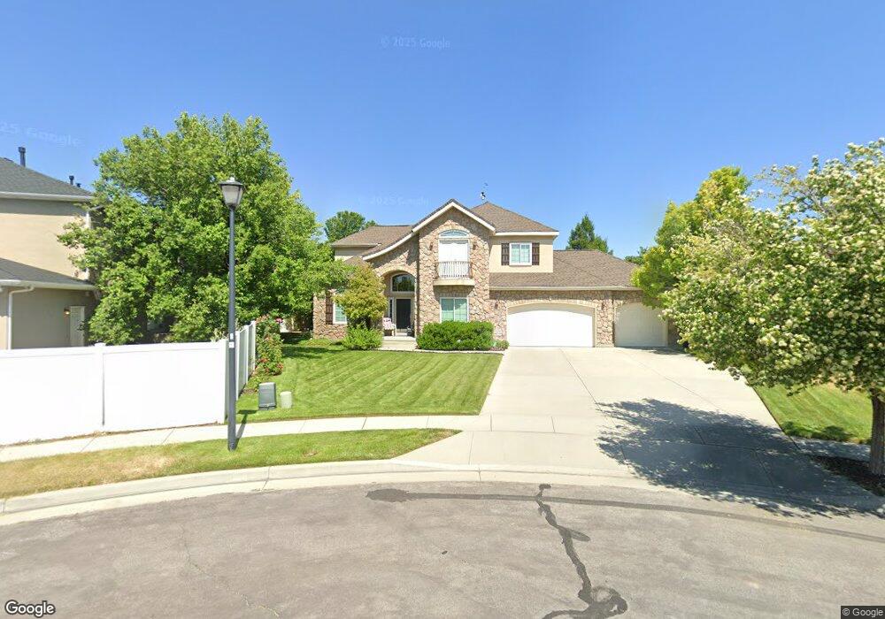
6308 S Table Rock Cir West Jordan, UT 84084
Estimated Value: $728,000 - $929,000
4
Beds
3
Baths
4,373
Sq Ft
$188/Sq Ft
Est. Value
About This Home
This home is located at 6308 S Table Rock Cir, West Jordan, UT 84084 and is currently estimated at $821,905, approximately $187 per square foot. 6308 S Table Rock Cir is a home located in Salt Lake County with nearby schools including Bennion Elementary School, Bennion Junior High School, and Taylorsville High School.
Ownership History
Date
Name
Owned For
Owner Type
Purchase Details
Closed on
Aug 30, 2001
Sold by
Ivory Homes Ltd
Bought by
Gross Kyle F and Gross Mary L
Current Estimated Value
Home Financials for this Owner
Home Financials are based on the most recent Mortgage that was taken out on this home.
Original Mortgage
$254,300
Interest Rate
6.65%
Create a Home Valuation Report for This Property
The Home Valuation Report is an in-depth analysis detailing your home's value as well as a comparison with similar homes in the area
Home Values in the Area
Average Home Value in this Area
Purchase History
| Date | Buyer | Sale Price | Title Company |
|---|---|---|---|
| Gross Kyle F | -- | Cottonwood Title Ins Agency |
Source: Public Records
Mortgage History
| Date | Status | Borrower | Loan Amount |
|---|---|---|---|
| Closed | Gross Kyle F | $254,300 | |
| Closed | Gross Kyle F | $47,685 |
Source: Public Records
Tax History Compared to Growth
Tax History
| Year | Tax Paid | Tax Assessment Tax Assessment Total Assessment is a certain percentage of the fair market value that is determined by local assessors to be the total taxable value of land and additions on the property. | Land | Improvement |
|---|---|---|---|---|
| 2025 | -- | $730,400 | $249,000 | $481,400 |
| 2024 | -- | $744,500 | $246,600 | $497,900 |
| 2023 | $4,232 | $680,700 | $237,100 | $443,600 |
| 2022 | $0 | $669,100 | $232,400 | $436,700 |
| 2021 | $4,735 | $555,700 | $230,600 | $325,100 |
| 2020 | $3,740 | $500,200 | $230,600 | $269,600 |
| 2019 | $2,895 | $473,200 | $217,600 | $255,600 |
| 2018 | $3,514 | $442,400 | $217,600 | $224,800 |
| 2017 | $3,096 | $409,700 | $217,600 | $192,100 |
| 2016 | $2,842 | $375,900 | $217,600 | $158,300 |
| 2015 | $2,895 | $357,800 | $187,500 | $170,300 |
| 2014 | -- | $326,200 | $172,700 | $153,500 |
Source: Public Records
Map
Nearby Homes
- 6438 Mckinley Ln
- 6474 Tamra Dr
- 3052 W Matterhorn Dr
- 3088 W Cisco Ridge Rd
- 6512 Timpanogos Way
- 6095 S Sierra Grande Dr
- 6016 S Paprika Cir
- 3117 W 6250 S
- 6007 S Sweet Basil N
- 1824 W 6200 S
- 5980 S Sweet Basil N
- 2342 W 6200 S
- 3075 Don Francisco Dr Unit 159
- 2332 Broderick Dr
- 2333 W Ledgewood Dr
- 3305 W Kingsbrook Ave
- 2250 W Tierra Rose Dr
- 2683 W Carson Ln
- 2322 W Surrey Rd
- 2137 W 6200 S
- 6308 Table Rock Cir
- 2766 Table Rock Dr
- 6307 Table Rock Cir
- 6307 S Table Rock Cir
- 6287 Mount Langley Cir
- 2782 Table Rock Dr
- 6311 Table Rock Cir
- 6277 Mount Langley Cir
- 6321 S Table Rock Cir Unit 431
- 6321 Table Rock Cir
- 2765 W Table Rock Dr
- 2779 Table Rock Dr
- 2765 Table Rock Dr
- 6344 Adirondack Way
- 2793 Table Rock Dr
- 6333 S Adirondack Way
- 6333 Adirondack Way
- 6273 S Mount Langley Cir
- 6273 Mount Langley Cir
- 6294 Mount Langley Cir