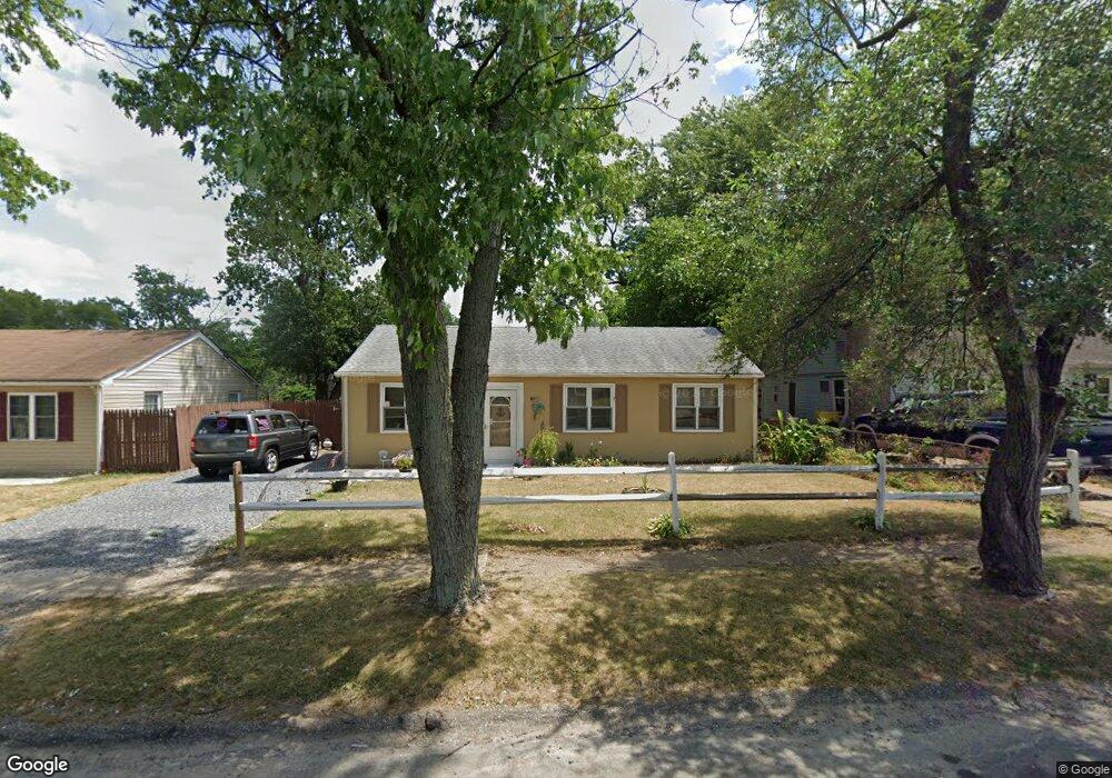
631 Binsted Rd Glen Burnie, MD 21060
Estimated Value: $308,717 - $347,000
Studio
1
Bath
988
Sq Ft
$338/Sq Ft
Est. Value
About This Home
This home is located at 631 Binsted Rd, Glen Burnie, MD 21060 and is currently estimated at $334,429, approximately $338 per square foot. 631 Binsted Rd is a home located in Anne Arundel County with nearby schools including Glendale Elementary School, Marley Middle School, and Glen Burnie High School.
Ownership History
Date
Name
Owned For
Owner Type
Purchase Details
Closed on
May 3, 2024
Sold by
Holman Barbara Kay and Obrocki Carol
Bought by
Ensley Douglas and Ensley Marcella
Current Estimated Value
Home Financials for this Owner
Home Financials are based on the most recent Mortgage that was taken out on this home.
Original Mortgage
$160,000
Outstanding Balance
$153,495
Interest Rate
6%
Mortgage Type
New Conventional
Estimated Equity
$180,934
Purchase Details
Closed on
Feb 23, 2023
Sold by
Holman James E
Bought by
Holman Barbara Kay and Obrocki Carol
Purchase Details
Closed on
Sep 8, 1992
Sold by
Kuethe Fredk W
Bought by
Ensley Douglas L and Ensley Et Al Marcella L
Home Financials for this Owner
Home Financials are based on the most recent Mortgage that was taken out on this home.
Original Mortgage
$87,500
Interest Rate
7.94%
Create a Home Valuation Report for This Property
The Home Valuation Report is an in-depth analysis detailing your home's value as well as a comparison with similar homes in the area
Home Values in the Area
Average Home Value in this Area
Purchase History
| Date | Buyer | Sale Price | Title Company |
|---|---|---|---|
| Ensley Douglas | $70,000 | None Listed On Document | |
| Ensley Douglas | $70,000 | None Listed On Document | |
| Holman Barbara Kay | -- | None Listed On Document | |
| Holman Barbara Kay | -- | None Listed On Document | |
| Ensley Douglas L | $88,000 | -- |
Source: Public Records
Mortgage History
| Date | Status | Borrower | Loan Amount |
|---|---|---|---|
| Open | Ensley Douglas | $160,000 | |
| Previous Owner | Ensley Douglas L | $87,500 |
Source: Public Records
Tax History
| Year | Tax Paid | Tax Assessment Tax Assessment Total Assessment is a certain percentage of the fair market value that is determined by local assessors to be the total taxable value of land and additions on the property. | Land | Improvement |
|---|---|---|---|---|
| 2025 | $2,721 | $215,400 | $143,100 | $72,300 |
| 2024 | $2,721 | $202,567 | $0 | $0 |
Source: Public Records
Map
Nearby Homes
- 1027 Upton Rd
- 1412 Houghton Rd
- 1514 Jupp Rd
- 102 Kent Rd
- 1003 Lee Rd
- 505 Aquahart Rd
- 106 3rd Ave SE
- 1702 Manning Rd
- 403 Arbor Dr
- 211 Georgia Ave NE
- 303 Oxford Dr
- 1200 Whitman Dr
- 518 Kintop Rd
- 1 Beach Rd
- 34 Elm Dr
- 443 M St NE
- 211 Aquahart Rd
- 15 Beach Rd
- 106 Heather Stone Way Unit 43
- 111 N Bend Terrace
Your Personal Tour Guide
Ask me questions while you tour the home.