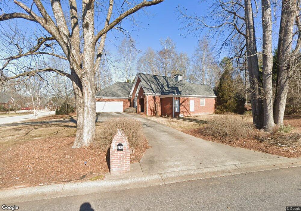
631 Chesterfield Rd Bogart, GA 30622
Estimated Value: $406,309 - $442,000
3
Beds
2
Baths
2,153
Sq Ft
$194/Sq Ft
Est. Value
About This Home
This home is located at 631 Chesterfield Rd, Bogart, GA 30622 and is currently estimated at $417,077, approximately $193 per square foot. 631 Chesterfield Rd is a home located in Clarke County with nearby schools including Cleveland Road Elementary School, Burney-Harris-Lyons Middle School, and Clarke Central High School.
Ownership History
Date
Name
Owned For
Owner Type
Purchase Details
Closed on
Mar 2, 2001
Sold by
H & B Homes Llc
Bought by
Brumby Edward H and Brumby Donna T
Current Estimated Value
Purchase Details
Closed on
Dec 15, 1999
Sold by
Willwork L L C
Bought by
H & B Homes Llc
Create a Home Valuation Report for This Property
The Home Valuation Report is an in-depth analysis detailing your home's value as well as a comparison with similar homes in the area
Home Values in the Area
Average Home Value in this Area
Purchase History
| Date | Buyer | Sale Price | Title Company |
|---|---|---|---|
| Brumby Edward H | $191,900 | -- | |
| H & B Homes Llc | $23,400 | -- |
Source: Public Records
Tax History Compared to Growth
Tax History
| Year | Tax Paid | Tax Assessment Tax Assessment Total Assessment is a certain percentage of the fair market value that is determined by local assessors to be the total taxable value of land and additions on the property. | Land | Improvement |
|---|---|---|---|---|
| 2025 | $2,954 | $155,282 | $18,000 | $137,282 |
| 2024 | $2,954 | $150,458 | $18,000 | $132,458 |
| 2023 | $2,979 | $140,990 | $18,000 | $122,990 |
| 2022 | $2,876 | $121,338 | $18,000 | $103,338 |
| 2021 | $2,747 | $100,475 | $16,000 | $84,475 |
| 2020 | $2,710 | $97,788 | $16,000 | $81,788 |
| 2019 | $2,612 | $89,158 | $16,000 | $73,158 |
| 2018 | $2,559 | $85,376 | $16,000 | $69,376 |
| 2017 | $2,379 | $80,080 | $16,000 | $64,080 |
| 2016 | $2,315 | $78,189 | $16,000 | $62,189 |
| 2015 | $2,215 | $75,123 | $16,000 | $59,123 |
| 2014 | $2,317 | $78,010 | $16,000 | $62,010 |
Source: Public Records
Map
Nearby Homes
- 682 Chesterfield Rd
- 190 W Huntington Rd
- 240 W Huntington Rd
- 100 Hanover Dr
- 212 Huntington Shoals Dr
- 241 Meeler Cir
- 141 Huntington Shoals Dr
- 637 Huntington Rd Unit B1
- 470 Huntington Rd Unit 5
- 532 Huntington Rd Unit 7
- 112 Deerhollow Rd
- 150 Callaway Dr
- 256 Cherokee Ridge
- 575 Vaughn Rd
- 240 Deerfield Rd
- 178 Ben Burton Cir
- 450 River Bottom Rd
- 211 Littleton Way
- 621 Chesterfield Rd
- 117 Brittany Rd
- 641 Chesterfield Rd
- 611 Chesterfield Rd
- 622 Chesterfield Rd
- 632 Chesterfield Rd
- 127 Brittany Rd
- 616 Chesterfield Rd
- 114 Brittany Rd
- 636 Chesterfield Rd
- 140 Chelsea Ct
- 124 Brittany Rd
- 612 Chesterfield Rd
- 601 Chesterfield Rd
- 651 Chesterfield Rd
- 160 Chelsea Ct
- 642 Chesterfield Rd
- 134 Brittany Rd
- 602 Chesterfield Rd
- 698 Cleveland Rd