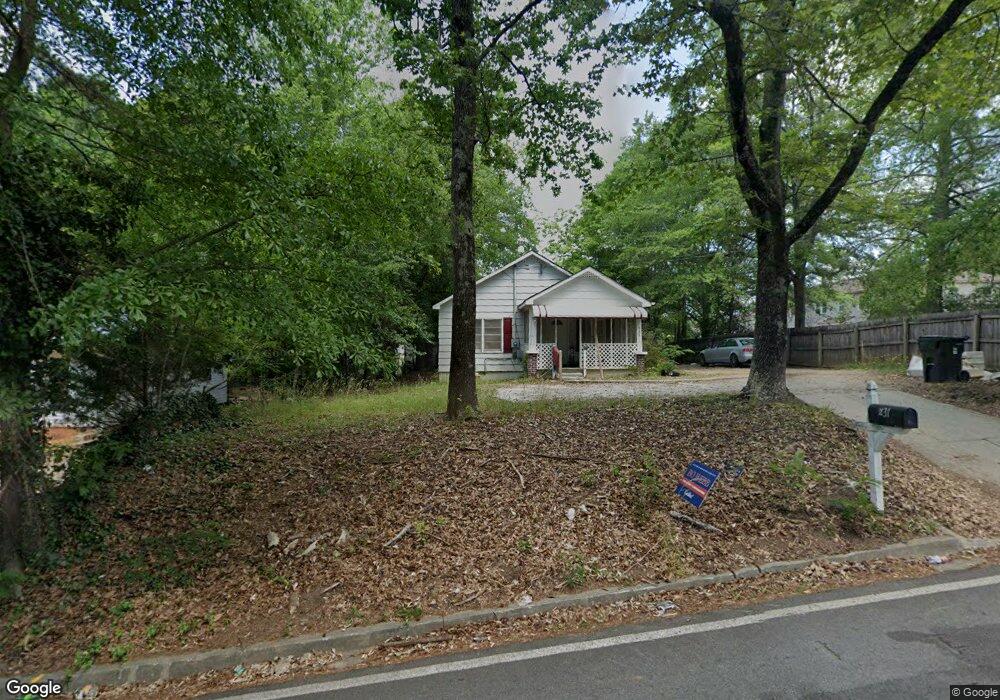
631 Davis Ave Toccoa, GA 30577
Estimated Value: $96,000 - $123,937
2
Beds
1
Bath
884
Sq Ft
$129/Sq Ft
Est. Value
About This Home
This home is located at 631 Davis Ave, Toccoa, GA 30577 and is currently estimated at $113,734, approximately $128 per square foot. 631 Davis Ave is a home located in Stephens County with nearby schools including Stephens County High School.
Ownership History
Date
Name
Owned For
Owner Type
Purchase Details
Closed on
Dec 17, 2021
Sold by
Lancaster Craig
Bought by
Markir Llc
Current Estimated Value
Purchase Details
Closed on
May 5, 2021
Sold by
Yopp Jerry B
Bought by
Lancaster Craig
Purchase Details
Closed on
May 31, 2007
Sold by
Not Provided
Bought by
Yopp Jerry and Yopp Mary
Purchase Details
Closed on
Mar 6, 2007
Sold by
Not Provided
Bought by
Yopp Jerry and Yopp Mary
Purchase Details
Closed on
Nov 19, 2001
Bought by
<Buyer Info Not Present>
Purchase Details
Closed on
Oct 1, 1995
Bought by
<Buyer Info Not Present>
Create a Home Valuation Report for This Property
The Home Valuation Report is an in-depth analysis detailing your home's value as well as a comparison with similar homes in the area
Purchase History
| Date | Buyer | Sale Price | Title Company |
|---|---|---|---|
| Markir Llc | -- | -- | |
| Lancaster Craig | $56,000 | -- | |
| Yopp Jerry | $15,000 | -- | |
| Yopp Jerry | $15,000 | -- | |
| Yopp Jerry | -- | -- | |
| Community Bank Trust | $26,221 | -- | |
| <Buyer Info Not Present> | -- | -- | |
| <Buyer Info Not Present> | $21,000 | -- |
Source: Public Records
Tax History
| Year | Tax Paid | Tax Assessment Tax Assessment Total Assessment is a certain percentage of the fair market value that is determined by local assessors to be the total taxable value of land and additions on the property. | Land | Improvement |
|---|---|---|---|---|
| 2025 | $1,130 | $32,399 | $1,375 | $31,024 |
| 2024 | $762 | $21,377 | $1,375 | $20,002 |
| 2023 | $703 | $19,869 | $1,375 | $18,494 |
| 2022 | $559 | $18,773 | $1,375 | $17,398 |
| 2021 | $543 | $17,364 | $1,375 | $15,989 |
| 2020 | $372 | $11,789 | $1,375 | $10,414 |
| 2019 | $374 | $11,789 | $1,375 | $10,414 |
| 2018 | $374 | $11,789 | $1,375 | $10,414 |
| 2017 | $380 | $11,789 | $1,375 | $10,414 |
| 2016 | $376 | $11,868 | $1,375 | $10,493 |
| 2015 | $397 | $11,939 | $1,375 | $10,564 |
| 2014 | $443 | $13,135 | $1,375 | $11,760 |
| 2013 | -- | $13,135 | $1,375 | $11,760 |
Source: Public Records
Map
Nearby Homes
- 0 Hwy 17 Alt Unit 10577119
- 41 Norwood Ave
- 59 Sunset Ln
- 45 Hayes St
- 100 Forest Ave
- 481 Collins Rd
- 30 Moore Ave
- 27 Hilltop Ln
- 288 Davis Ave
- 899 E Doyle St
- 9 Poplar St
- 122 King St
- 185 Stancil Dr
- 109 Schaefer Ct
- 22 Green Hill Place
- 239 E Doyle St
- 253 Stancil Dr
- 128 Branch St
- 157 Taylor St
- 1168 Rosedale St
Your Personal Tour Guide
Ask me questions while you tour the home.