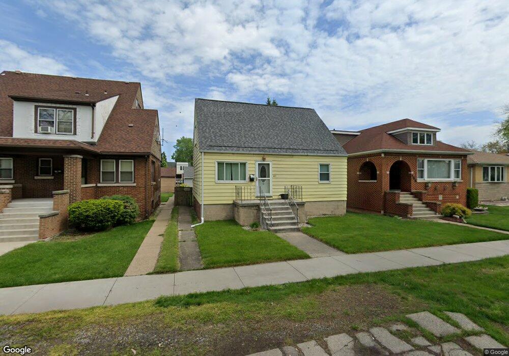
631 Roosevelt Dr Whiting, IN 46394
Estimated Value: $187,000 - $237,085
4
Beds
2
Baths
1,392
Sq Ft
$153/Sq Ft
Est. Value
About This Home
This home is located at 631 Roosevelt Dr, Whiting, IN 46394 and is currently estimated at $212,771, approximately $152 per square foot. 631 Roosevelt Dr is a home located in Lake County with nearby schools including Benjamin Franklin Elementary School, Eggers Middle School, and Hammond High School.
Ownership History
Date
Name
Owned For
Owner Type
Purchase Details
Closed on
Aug 30, 2005
Sold by
Traczyk Lorraine P
Bought by
Parsons Eric P
Current Estimated Value
Home Financials for this Owner
Home Financials are based on the most recent Mortgage that was taken out on this home.
Original Mortgage
$75,000
Outstanding Balance
$40,327
Interest Rate
5.93%
Mortgage Type
Fannie Mae Freddie Mac
Estimated Equity
$172,444
Create a Home Valuation Report for This Property
The Home Valuation Report is an in-depth analysis detailing your home's value as well as a comparison with similar homes in the area
Home Values in the Area
Average Home Value in this Area
Purchase History
| Date | Buyer | Sale Price | Title Company |
|---|---|---|---|
| Parsons Eric P | -- | Community Title Company |
Source: Public Records
Mortgage History
| Date | Status | Borrower | Loan Amount |
|---|---|---|---|
| Open | Parsons Eric P | $75,000 |
Source: Public Records
Tax History Compared to Growth
Tax History
| Year | Tax Paid | Tax Assessment Tax Assessment Total Assessment is a certain percentage of the fair market value that is determined by local assessors to be the total taxable value of land and additions on the property. | Land | Improvement |
|---|---|---|---|---|
| 2024 | $6,147 | $135,400 | $35,600 | $99,800 |
| 2023 | $1,599 | $128,600 | $33,300 | $95,300 |
| 2022 | $1,599 | $126,100 | $33,300 | $92,800 |
| 2021 | $1,306 | $105,000 | $16,700 | $88,300 |
| 2020 | $1,211 | $98,100 | $16,700 | $81,400 |
| 2019 | $1,278 | $95,600 | $16,700 | $78,900 |
| 2018 | $1,238 | $89,900 | $16,700 | $73,200 |
| 2017 | $1,309 | $87,500 | $16,700 | $70,800 |
| 2016 | $2,679 | $86,500 | $16,700 | $69,800 |
| 2014 | $1,246 | $93,900 | $16,700 | $77,200 |
| 2013 | $1,519 | $97,200 | $16,700 | $80,500 |
Source: Public Records
Map
Nearby Homes
- 1944 Warwick Ave
- 1717 Warwick Ave
- 1709 Parkview Ave
- 1726 Davis Ave
- 2024 Lake Ave
- 2231 Davis Ave
- 1916 Wespark Ave
- 1539 Warwick Ave
- 1529 Warwick Ave
- 1014 Reese Ave
- 2134 Lincoln Ave
- 2036 Atchison Ave
- 1710 Atchison Ave
- 1430 Stanton Ave
- 1514 Amy Ave
- 1643 Roberts Ave
- 1423 Lake Ave
- 1511 Roberts Ave
- 1630 Cleveland Ave
- 1409 Lake Ave
- 625 Roosevelt Dr
- 637 Roosevelt Dr
- 633 Roosevelt Dr
- 1962 Hamann Ct
- 663 Roosevelt Dr
- 2018 Hamann Ct
- 638 Burton Ct
- 632 Burton Ct
- 1956 Hamann Ct
- 642 Burton Ct
- 628 Burton Ct
- 615 Roosevelt Dr Unit 17
- 626 Roosevelt Dr
- 644 Burton Ct
- 632 Roosevelt Dr
- 630 Roosevelt Dr
- 634 Roosevelt Dr
- 648 Burton Ct
- 620 Roosevelt Dr
- 609 Roosevelt Dr