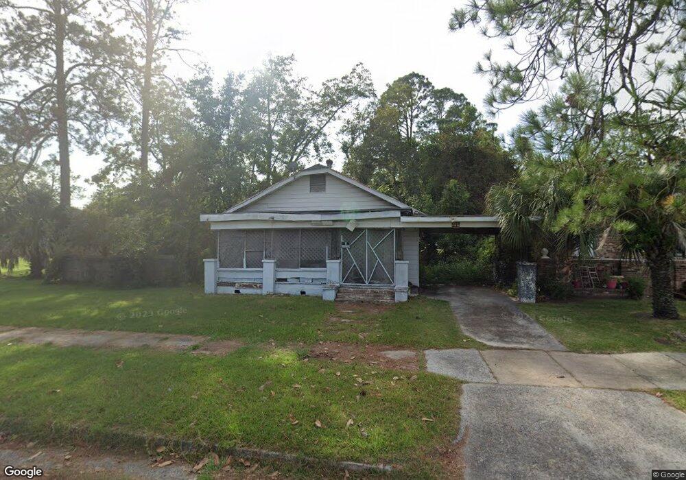
631 Ware St Waycross, GA 31503
Estimated Value: $79,127 - $108,000
3
Beds
1
Bath
1,290
Sq Ft
$69/Sq Ft
Est. Value
About This Home
This home is located at 631 Ware St, Waycross, GA 31503 and is currently estimated at $89,282, approximately $69 per square foot. 631 Ware St is a home located in Ware County with nearby schools including Waresboro Elementary School, Ware County Middle School, and Ware County High School.
Ownership History
Date
Name
Owned For
Owner Type
Purchase Details
Closed on
Jan 8, 2019
Sold by
Clark Tiwanna Thomas
Bought by
Mohamed Elouthmani
Current Estimated Value
Purchase Details
Closed on
Mar 3, 2005
Sold by
Brown Willie J
Bought by
Clark Tiwanna Thomas
Purchase Details
Closed on
Nov 4, 1996
Sold by
Thomas Tiwanna
Bought by
Brown Willie J
Purchase Details
Closed on
Apr 24, 1990
Bought by
Thomas Tiwanna
Create a Home Valuation Report for This Property
The Home Valuation Report is an in-depth analysis detailing your home's value as well as a comparison with similar homes in the area
Home Values in the Area
Average Home Value in this Area
Purchase History
| Date | Buyer | Sale Price | Title Company |
|---|---|---|---|
| Mohamed Elouthmani | $4,500 | -- | |
| Clark Tiwanna Thomas | -- | -- | |
| Brown Willie J | -- | -- | |
| Thomas Tiwanna | $15,000 | -- |
Source: Public Records
Tax History Compared to Growth
Tax History
| Year | Tax Paid | Tax Assessment Tax Assessment Total Assessment is a certain percentage of the fair market value that is determined by local assessors to be the total taxable value of land and additions on the property. | Land | Improvement |
|---|---|---|---|---|
| 2024 | $462 | $13,160 | $1,330 | $11,830 |
| 2023 | $454 | $7,968 | $1,094 | $6,874 |
| 2022 | $318 | $7,968 | $1,094 | $6,874 |
| 2021 | $244 | $5,638 | $1,094 | $4,544 |
| 2020 | $78 | $5,557 | $1,094 | $4,463 |
| 2019 | $291 | $8,390 | $1,094 | $7,296 |
| 2018 | $294 | $8,042 | $1,094 | $6,948 |
| 2017 | $285 | $8,042 | $1,094 | $6,948 |
| 2016 | $285 | $8,042 | $1,094 | $6,948 |
| 2015 | $287 | $8,042 | $1,094 | $6,948 |
| 2014 | $287 | $8,042 | $1,094 | $6,948 |
| 2013 | -- | $8,042 | $1,094 | $6,948 |
Source: Public Records
Map
Nearby Homes
- 1006 Roosevelt St
- 601 N Nicholls St
- 1003 Carswell Ave
- 629 Remshart St
- 505 N Nicholls St
- 605 Walker St
- 503 N Nicholls St
- 516 Folks St
- 506 McDonald St
- 00 Roosevelt St
- 1027 Robert St
- 803 Elizabeth St
- 812 Effie St
- 1401 Carswell Ave
- 1208 Margaret St
- 1103 Ann St
- 0 Camp Branch Cross Rd Unit 12958956
- 0 Camp Branch Cross Rd Unit 147575
- 0 Camp Branch Cross Rd Unit 10127958
- 1322 Jane St
- 633 Ware St
- 622 N Nicholls St
- 624 N Nicholls St
- 628 Ware St
- 626 N Nicholls St
- 624 Ware St
- 637 Ware St
- 619 Ware St
- 630 Ware St
- 628 N Nicholls St
- 620 Ware St
- 630 N Nicholls St
- 618 Ware St
- 617 N Nicholls St
- 616 N Nicholls St
- 623 N Nicholls St
- 621 N Nicholls St
- 627 McDonald St
- 629 McDonald St
- 625 N Nicholls St