Estimated Value: $323,000 - $449,722
4
Beds
4
Baths
3,356
Sq Ft
$116/Sq Ft
Est. Value
About This Home
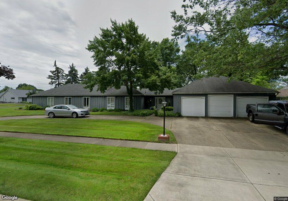
This home is located at 631 Wyleswood Dr, Berea, OH 44017 and is currently estimated at $390,931, approximately $116 per square foot. 631 Wyleswood Dr is a home located in Cuyahoga County with nearby schools including Grindstone Elementary School, Berea-Midpark Middle School, and Berea-Midpark High School.
Ownership History
Date
Name
Owned For
Owner Type
Purchase Details
Closed on
Sep 9, 1977
Sold by
Lavelle Frank D and Lavelle Louise A
Bought by
Badawy Basil H
Current Estimated Value
Purchase Details
Closed on
Jan 1, 1975
Bought by
Lavelle Frank D and Lavelle Louise A
Create a Home Valuation Report for This Property
The Home Valuation Report is an in-depth analysis detailing your home's value as well as a comparison with similar homes in the area
Home Values in the Area
Average Home Value in this Area
Purchase History
| Date | Buyer | Sale Price | Title Company |
|---|---|---|---|
| Badawy Basil H | $135,000 | -- | |
| Lavelle Frank D | -- | -- |
Source: Public Records
Tax History Compared to Growth
Tax History
| Year | Tax Paid | Tax Assessment Tax Assessment Total Assessment is a certain percentage of the fair market value that is determined by local assessors to be the total taxable value of land and additions on the property. | Land | Improvement |
|---|---|---|---|---|
| 2024 | $7,227 | $134,575 | $19,845 | $114,730 |
| 2023 | $6,253 | $99,510 | $16,980 | $82,530 |
| 2022 | $6,242 | $99,510 | $16,980 | $82,530 |
| 2021 | $6,187 | $99,510 | $16,980 | $82,530 |
| 2020 | $5,810 | $84,320 | $14,390 | $69,930 |
| 2019 | $5,655 | $240,900 | $41,100 | $199,800 |
| 2018 | $5,623 | $84,320 | $14,390 | $69,930 |
| 2017 | $5,469 | $76,940 | $12,990 | $63,950 |
| 2016 | $5,429 | $76,940 | $12,990 | $63,950 |
| 2015 | $5,435 | $76,940 | $12,990 | $63,950 |
| 2014 | $5,435 | $81,000 | $13,690 | $67,310 |
Source: Public Records
Map
Nearby Homes
- 455 Woodridge Cir
- Daffodil II Plan at Aspire at Longbrooke
- Passionflower II Plan at Aspire at Longbrooke
- 540 Crossbrook Dr
- 549 Wyleswood Dr
- 543 Wyleswood Dr
- 537 Wyleswood Dr
- 580 Crossbrook Dr
- 396 Crossbrook Dr
- 517 Wyleswood Dr
- 8797 Westlawn Blvd
- 23390 Wainwright Terrace
- 626 Ensenada Ct Unit 5
- 23450 Wainwright Terrace
- 412 Wyleswood Dr
- 8873 Ashlyn Ct Unit 13A
- 23155 Wainwright Terrace
- 23002 Chandlers Ln
- 23002 Chandlers Ln Unit 342
- 23002 Chandlers Ln Unit 221
- 494 Crossbrook Dr
- 643 Wyleswood Dr
- 632 Wyleswood Dr
- 502 Crossbrook Dr
- 622 Wyleswood Dr
- 609 Wyleswood Dr
- 495 Crossbrook Dr
- 475 Haverhill Cir
- 651 Wyleswood Dr
- 503 Crossbrook Dr
- 468 Crossbrook Dr
- 652 Wyleswood Dr
- 479 Haverhill Cir
- 604 Wyleswood Dr
- 447 Woodridge Cir
- 458 Crossbrook Dr
- 467 Crossbrook Dr
- 448 Woodridge Cir
- 660 Wyleswood Dr
- 480 Haverhill Cir