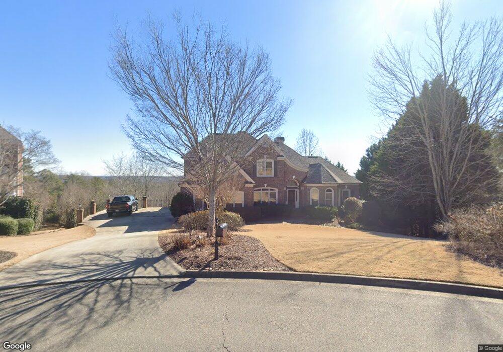
6310 Colwyn Ct Cumming, GA 30041
Estimated Value: $787,157 - $874,000
4
Beds
4
Baths
3,156
Sq Ft
$261/Sq Ft
Est. Value
About This Home
This home is located at 6310 Colwyn Ct, Cumming, GA 30041 and is currently estimated at $824,539, approximately $261 per square foot. 6310 Colwyn Ct is a home located in Forsyth County with nearby schools including Haw Creek Elementary School, Lakeside Middle School, and South Forsyth High School.
Ownership History
Date
Name
Owned For
Owner Type
Purchase Details
Closed on
Sep 1, 2000
Sold by
Iron Horse Homes Llc
Bought by
Daves Steven C and Daves Susan G
Current Estimated Value
Home Financials for this Owner
Home Financials are based on the most recent Mortgage that was taken out on this home.
Original Mortgage
$319,100
Outstanding Balance
$116,383
Interest Rate
8.11%
Mortgage Type
New Conventional
Estimated Equity
$708,156
Create a Home Valuation Report for This Property
The Home Valuation Report is an in-depth analysis detailing your home's value as well as a comparison with similar homes in the area
Home Values in the Area
Average Home Value in this Area
Purchase History
| Date | Buyer | Sale Price | Title Company |
|---|---|---|---|
| Daves Steven C | $399,100 | -- |
Source: Public Records
Mortgage History
| Date | Status | Borrower | Loan Amount |
|---|---|---|---|
| Open | Daves Steven C | $319,100 |
Source: Public Records
Tax History Compared to Growth
Tax History
| Year | Tax Paid | Tax Assessment Tax Assessment Total Assessment is a certain percentage of the fair market value that is determined by local assessors to be the total taxable value of land and additions on the property. | Land | Improvement |
|---|---|---|---|---|
| 2025 | $6,416 | $327,016 | $76,000 | $251,016 |
| 2024 | $6,416 | $312,204 | $68,000 | $244,204 |
| 2023 | $5,991 | $306,140 | $60,000 | $246,140 |
| 2022 | $5,487 | $185,880 | $32,000 | $153,880 |
| 2021 | $4,823 | $185,880 | $32,000 | $153,880 |
| 2020 | $4,858 | $187,544 | $32,000 | $155,544 |
| 2019 | $4,866 | $187,608 | $32,000 | $155,608 |
| 2018 | $4,509 | $169,952 | $32,000 | $137,952 |
| 2017 | $4,621 | $174,412 | $32,000 | $142,412 |
| 2016 | $4,299 | $159,172 | $26,000 | $133,172 |
| 2015 | $4,306 | $159,172 | $26,000 | $133,172 |
| 2014 | $3,820 | $147,596 | $26,000 | $121,596 |
Source: Public Records
Map
Nearby Homes
- Manchester Plan at The Glade
- Belville Plan at The Glade
- Milton Plan at The Glade
- 2216 Trammel Rd
- 7029 Bennington Ln
- 2640 Blackstock Dr
- 2625 Blackstock Dr
- 7047 Bennington Ln
- 1920 Daves Creek Trail
- 5613 Lancashire Ln
- 2376 Holly Ct
- 8355 Ainsworth Dr
- 8640 Amsbury Way
- 5349 Davenport Manor
- 2390 Colchester Ct
- 5303 Davenport Manor
- 2945 Links View Way
- 5985 Marlow Dr
- 6240 Creekstone Path
- 6320 Colwyn Ct
- 0 Creekstone Path Unit 8629014
- 0 Creekstone Path Unit 3270324
- 0 Creekstone Path Unit 8224377
- 0 Creekstone Path Unit 8648227
- 0 Creekstone Path Unit 8786908
- 0 Creekstone Path Unit 8880364
- 0 Creekstone Path Unit 3229551
- 0 Creekstone Path Unit 3276588
- 0 Creekstone Path Unit 7003570
- 0 Creekstone Path Unit 7270319
- 0 Creekstone Path Unit 7306060
- 0 Creekstone Path Unit 7434170
- 0 Creekstone Path Unit 7446869
- 0 Creekstone Path Unit 7504524
- 0 Creekstone Path Unit 7510156
- 0 Creekstone Path Unit 7553753
- 0 Creekstone Path Unit 8011663
- 0 Creekstone Path Unit 8083969