Estimated Value: $324,000 - $391,000
3
Beds
2
Baths
1,760
Sq Ft
$205/Sq Ft
Est. Value
About This Home
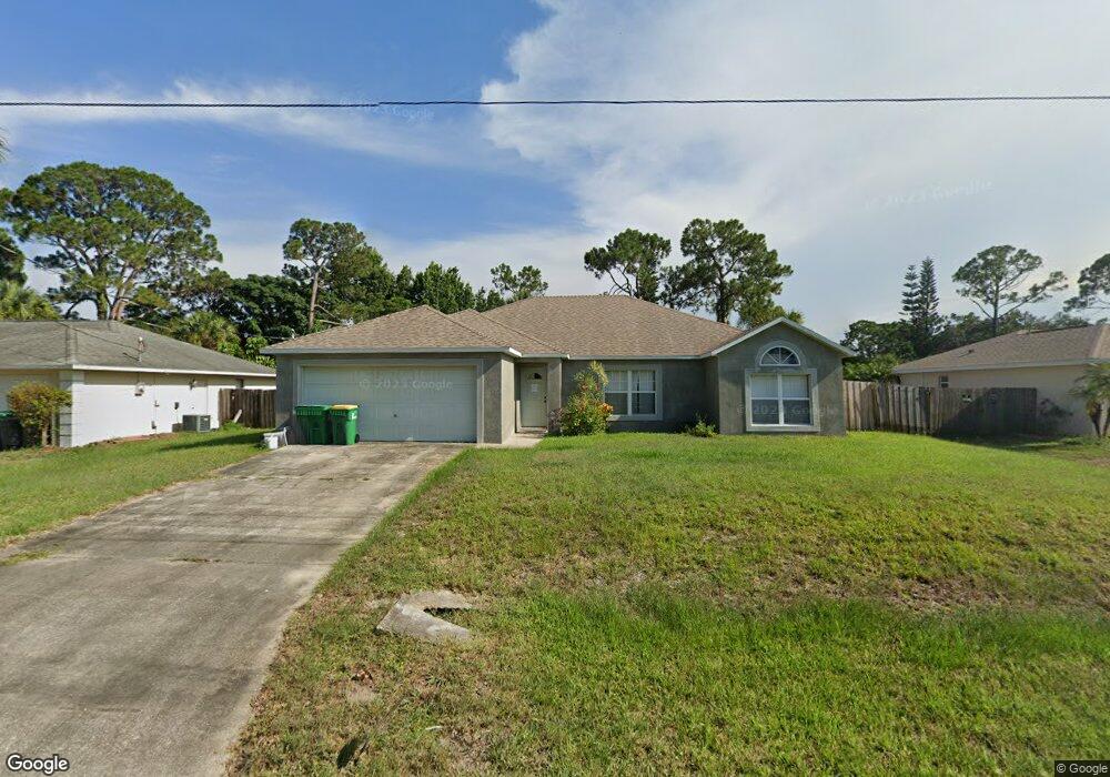
This home is located at 6319 Hudson Rd, Cocoa, FL 32927 and is currently estimated at $360,682, approximately $204 per square foot. 6319 Hudson Rd is a home located in Brevard County with nearby schools including Enterprise Elementary School, Space Coast Junior/Senior High School, and East Atlantic Prep of Brevard County.
Ownership History
Date
Name
Owned For
Owner Type
Purchase Details
Closed on
Jun 21, 2016
Sold by
Cain Jennjfer W and Bishop Jennifer W
Bought by
Cain James A
Current Estimated Value
Purchase Details
Closed on
Feb 13, 2004
Sold by
Warriner William D and Warriner Kathy J
Bought by
Cain James A and Cain Jennifer W
Home Financials for this Owner
Home Financials are based on the most recent Mortgage that was taken out on this home.
Original Mortgage
$112,000
Interest Rate
5.87%
Purchase Details
Closed on
Aug 13, 1999
Sold by
Maronda Homes Inc Fl
Bought by
Warriner William D and Warriner Kathy J
Home Financials for this Owner
Home Financials are based on the most recent Mortgage that was taken out on this home.
Original Mortgage
$94,605
Interest Rate
7.65%
Purchase Details
Closed on
May 18, 1999
Sold by
Schaufele Fraser G
Bought by
Maronda Homes Inc Fl
Purchase Details
Closed on
Mar 1, 1999
Sold by
Schaufele Fraser G
Bought by
Maronda Homes Inc Fl
Create a Home Valuation Report for This Property
The Home Valuation Report is an in-depth analysis detailing your home's value as well as a comparison with similar homes in the area
Home Values in the Area
Average Home Value in this Area
Purchase History
| Date | Buyer | Sale Price | Title Company |
|---|---|---|---|
| Cain James A | -- | None Available | |
| Cain James A | $140,000 | Security First Title Partner | |
| Warriner William D | $92,800 | -- | |
| Maronda Homes Inc Fl | -- | -- | |
| Maronda Homes Inc Fl | $9,500 | -- |
Source: Public Records
Mortgage History
| Date | Status | Borrower | Loan Amount |
|---|---|---|---|
| Previous Owner | Cain James A | $112,000 | |
| Previous Owner | Warriner William D | $94,605 |
Source: Public Records
Tax History
| Year | Tax Paid | Tax Assessment Tax Assessment Total Assessment is a certain percentage of the fair market value that is determined by local assessors to be the total taxable value of land and additions on the property. | Land | Improvement |
|---|---|---|---|---|
| 2025 | $2,125 | $161,370 | -- | -- |
| 2024 | $2,085 | $156,830 | -- | -- |
| 2023 | $2,085 | $152,270 | $0 | $0 |
| 2022 | $1,950 | $147,840 | $0 | $0 |
| 2021 | $1,976 | $143,540 | $0 | $0 |
| 2020 | $1,921 | $141,560 | $0 | $0 |
| 2019 | $1,863 | $138,380 | $0 | $0 |
| 2018 | $1,864 | $135,800 | $0 | $0 |
| 2017 | $2,585 | $140,020 | $24,000 | $116,020 |
| 2016 | $1,448 | $102,730 | $18,000 | $84,730 |
| 2015 | $1,577 | $92,330 | $15,000 | $77,330 |
| 2014 | $1,481 | $87,420 | $11,000 | $76,420 |
Source: Public Records
Map
Nearby Homes
- 5720 Flint Rd
- 6010 Fay Blvd
- 6438 Hudson Rd
- 6365 Homestead Ave
- 5715 Fairbridge St
- 5946 Deer Ln
- 6481 La Brea Ave
- 23-35-21-JX-B-2 Aruin St
- 6085 Edison St
- 5945 Coker Ave
- 6581 Bancroft Ave
- 5812 Homestead Ave
- 5221 Carrick Rd
- 6545 Addie Ave
- 23-35-21-J No Name
- 5220 Holden Rd
- 5215 Holden Rd
- 6020 Cannon Ave
- 6450 Ember Ave
- 6200 Edison St
Your Personal Tour Guide
Ask me questions while you tour the home.