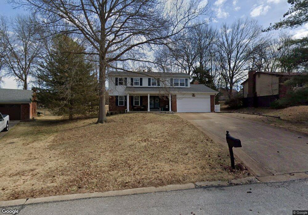
632 Crowsnest Dr Ballwin, MO 63021
Estimated Value: $333,000 - $425,000
4
Beds
3
Baths
2,232
Sq Ft
$178/Sq Ft
Est. Value
About This Home
This home is located at 632 Crowsnest Dr, Ballwin, MO 63021 and is currently estimated at $396,189, approximately $177 per square foot. 632 Crowsnest Dr is a home located in St. Louis County with nearby schools including Ballwin Elementary School, Selvidge Middle School, and Marquette Sr. High School.
Ownership History
Date
Name
Owned For
Owner Type
Purchase Details
Closed on
May 23, 2012
Sold by
Clar Kenneth A and Clar Jo Ann
Bought by
Klevorn Michael T and Klevorn Tegan L
Current Estimated Value
Home Financials for this Owner
Home Financials are based on the most recent Mortgage that was taken out on this home.
Original Mortgage
$152,092
Outstanding Balance
$107,928
Interest Rate
4.5%
Mortgage Type
FHA
Estimated Equity
$288,261
Create a Home Valuation Report for This Property
The Home Valuation Report is an in-depth analysis detailing your home's value as well as a comparison with similar homes in the area
Home Values in the Area
Average Home Value in this Area
Purchase History
| Date | Buyer | Sale Price | Title Company |
|---|---|---|---|
| Klevorn Michael T | $154,900 | Investors Title Co Clayton |
Source: Public Records
Mortgage History
| Date | Status | Borrower | Loan Amount |
|---|---|---|---|
| Open | Klevorn Michael T | $152,092 |
Source: Public Records
Tax History
| Year | Tax Paid | Tax Assessment Tax Assessment Total Assessment is a certain percentage of the fair market value that is determined by local assessors to be the total taxable value of land and additions on the property. | Land | Improvement |
|---|---|---|---|---|
| 2025 | $4,435 | $63,970 | $22,060 | $41,910 |
| 2024 | $4,435 | $63,380 | $18,390 | $44,990 |
| 2023 | $4,435 | $63,380 | $18,390 | $44,990 |
| 2022 | $3,165 | $41,930 | $18,390 | $23,540 |
| 2021 | $3,141 | $41,930 | $18,390 | $23,540 |
| 2020 | $3,073 | $39,100 | $17,270 | $21,830 |
| 2019 | $3,085 | $39,100 | $17,270 | $21,830 |
| 2018 | $2,953 | $35,280 | $13,450 | $21,830 |
| 2017 | $2,884 | $35,280 | $13,450 | $21,830 |
| 2016 | $2,455 | $28,840 | $9,610 | $19,230 |
| 2015 | $2,406 | $28,840 | $9,610 | $19,230 |
| 2014 | $3,209 | $37,620 | $10,960 | $26,660 |
Source: Public Records
Map
Nearby Homes
- 407 Tulsa Ave
- 893 Napoli Dr
- 798 Canary Dr
- 304 Wembley Ln
- 709 Windingpath Ln
- The Nantucket Vista Plan at Sulphur Spring
- The Parkview II Vista Plan at Sulphur Spring
- The Nantucket II Vista Plan at Sulphur Spring
- The Westbrooke Vista Plan at Sulphur Spring
- 284 Brightfield Dr
- 275 Essen Ct Unit TBB
- 212 Lindy Blvd
- 277 Ramsey Ln
- 108 Maple Ln
- 836 Wheelwright Dr
- 365 Remington Way Dr
- 105 Timka Dr
- 0 the Rainier@joyce Ann Dr
- New Build Forest J at Joyce Ann Dr
- 1152 Hollyberry Dr
- 646 Crowsnest Dr
- 618 Crowsnest Dr
- 815 Reindeer Dr
- 839 Reindeer Dr
- 225 Crowsnest Dr
- 224 Crowsnest Dr
- 643 Crowsnest Dr
- 843 Reindeer Dr
- 811 Reindeer Dr
- 668 Crowsnest Dr
- 219 Crowsnest Dr
- 655 Crowsnest Dr
- 847 Reindeer Dr
- 807 Reindeer Dr
- 3 Amber Jack Ct
- 4 Amber Jack Ct
- 814 Reindeer Dr
- 851 Reindeer Dr
- 840 Reindeer Dr
- 680 Crowsnest Dr