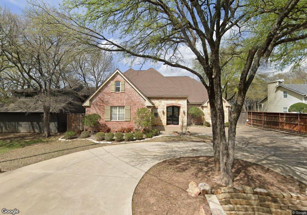
632 Russwood Dr Pottsboro, TX 75076
Estimated Value: $634,228 - $823,000
--
Bed
--
Bath
2,551
Sq Ft
$286/Sq Ft
Est. Value
About This Home
This home is located at 632 Russwood Dr, Pottsboro, TX 75076 and is currently estimated at $728,614, approximately $285 per square foot. 632 Russwood Dr is a home located in Grayson County with nearby schools including Pottsboro Elementary School, Pottsboro Middle School, and Pottsboro High School.
Ownership History
Date
Name
Owned For
Owner Type
Purchase Details
Closed on
Jan 19, 2005
Sold by
Cleaves Robert L
Bought by
Burton Dale R and Burton Melody K
Current Estimated Value
Home Financials for this Owner
Home Financials are based on the most recent Mortgage that was taken out on this home.
Original Mortgage
$422,500
Outstanding Balance
$202,658
Interest Rate
5%
Mortgage Type
Purchase Money Mortgage
Estimated Equity
$525,956
Create a Home Valuation Report for This Property
The Home Valuation Report is an in-depth analysis detailing your home's value as well as a comparison with similar homes in the area
Home Values in the Area
Average Home Value in this Area
Purchase History
| Date | Buyer | Sale Price | Title Company |
|---|---|---|---|
| Burton Dale R | -- | -- |
Source: Public Records
Mortgage History
| Date | Status | Borrower | Loan Amount |
|---|---|---|---|
| Open | Burton Dale R | $422,500 |
Source: Public Records
Tax History Compared to Growth
Tax History
| Year | Tax Paid | Tax Assessment Tax Assessment Total Assessment is a certain percentage of the fair market value that is determined by local assessors to be the total taxable value of land and additions on the property. | Land | Improvement |
|---|---|---|---|---|
| 2025 | $3,358 | $644,475 | $161,623 | $482,852 |
| 2024 | $8,404 | $606,583 | $0 | $0 |
| 2023 | $3,229 | $551,439 | $0 | $0 |
| 2022 | $7,890 | $501,308 | $125,840 | $375,468 |
| 2021 | $8,222 | $505,564 | $108,150 | $397,414 |
| 2020 | $8,110 | $480,416 | $112,500 | $367,916 |
| 2019 | $7,801 | $460,198 | $112,500 | $347,698 |
| 2018 | $7,182 | $400,877 | $79,540 | $321,337 |
| 2017 | $6,895 | $379,880 | $79,540 | $300,340 |
| 2016 | $6,772 | $373,134 | $79,830 | $293,304 |
| 2015 | $5,445 | $340,972 | $79,830 | $261,142 |
| 2014 | $5,746 | $349,574 | $79,830 | $269,744 |
Source: Public Records
Map
Nearby Homes
- 110 Eagleview Cir
- 120 Eagleview Cir
- 105 Eagleview Cir
- 210 Walnut Ln
- 219 Ray Rd
- 33 Queens Dr
- 11 Mayfield Ln
- 83 Mayfield Ln
- 344 Castle Dr
- 491 Black Forest Dr
- 545 Black Forest Dr
- 226 Cambridge Dr
- 16 Wales Dr
- 142 Wales Dr
- 191 Black Forest Dr
- 34 Cambridge Dr
- 81 Windsor Dr
- 207 Wales Dr
- 137 Anderson Ln
- 258 Lou-Sand Hill Rd
- 659 Russwood Dr
- 610 Russwood Dr
- 660 Russwood Dr
- 570 Russwood Dr
- 554 Russwood Dr
- 730 Russwood Dr
- 524 Russwood Dr
- 510 Russwood Dr
- 101 Hilltop Ln
- 104 Red Bud Ln
- 125 Eagleview Cir
- 104 Eagleview Cir
- 105 Hilltop Ln
- 747 Russwood Dr
- 105 Russwood Dr
- 345 Russwood Dr
- 106 Hilltop Ln
- 574 Kirk Ave
- 124 Eagleview Cir
- 546 Kirk Ave