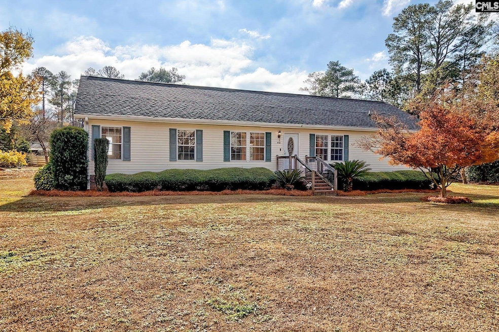
632 Spruce Ln West Columbia, SC 29172
Pine Ridge NeighborhoodEstimated payment $1,386/month
Highlights
- Very Popular Property
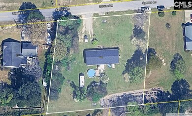
- 0.92 Acre Lot
- No HOA
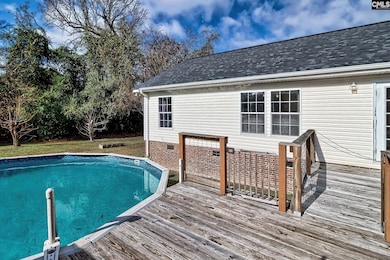
- Above Ground Pool
- Deck
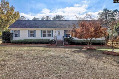
- Front Porch
About This Home
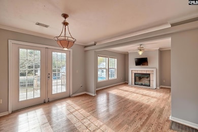
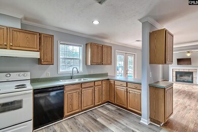
Beautiful and well-maintained, energy-efficient, 1 story modular home on nearly 1 acre of land! This well-maintained 4 BR / 2 BA home is perfect for the growing family who wants a little elbow room. There have been lots of updates along the way, including new paint in several rooms throughout and new flooring in the kitchen and laundry room. The kitchen has lots of cabinet and counter space. The living room is warm and inviting with a fireplace that is perfect for family movie night. As you walk out the back door onto your lovely deck, imagine grilling out with family and friends on those spectacular summer evenings. When it gets too hot, take a dip in Your new pool! It is so peaceful and quiet, there is a lot to like about this lovely home. Schedule a time for a showing today! Disclaimer: CMLS has not reviewed and, therefore, does not endorse vendors who may appear in listings.
Home Details
Home Type
- Single Family
Year Built
- Built in 2004
Lot Details
- 0.92 Acre Lot
Home Design
- Vinyl Construction Material
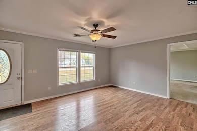
Interior Spaces
- 1,904 Sq Ft Home
- 1-Story Property
- Crown Molding
- Ceiling Fan
- Recessed Lighting
- Wood Burning Fireplace
- French Doors
- Living Room with Fireplace
- Dining Area
- Crawl Space
Kitchen
- Free-Standing Range
- Dishwasher
- Formica Countertops
Flooring
- Carpet
- Laminate
- Luxury Vinyl Plank Tile
Bedrooms and Bathrooms
- 4 Bedrooms
- Walk-In Closet
- 2 Full Bathrooms
- Garden Bath
- Separate Shower
Laundry
- Laundry in Mud Room
- Laundry Room
- Laundry on main level
Outdoor Features
- Above Ground Pool
- Deck
- Shed
- Front Porch
Schools
- Wood Elementary School
- Pine Ridge Middle School
- Airport High School
Utilities
- Central Heating and Cooling System
- Well
- Water Heater
- Septic System
- Cable TV Available
Community Details
- No Home Owners Association
Map
Home Values in the Area
Average Home Value in this Area
Tax History
| Year | Tax Paid | Tax Assessment Tax Assessment Total Assessment is a certain percentage of the fair market value that is determined by local assessors to be the total taxable value of land and additions on the property. | Land | Improvement |
|---|---|---|---|---|
| 2024 | $840 | $5,504 | $600 | $4,904 |
| 2023 | $779 | $5,504 | $600 | $4,904 |
| 2022 | $779 | $5,504 | $600 | $4,904 |
| 2020 | $775 | $5,504 | $600 | $4,904 |
| 2019 | $776 | $5,394 | $600 | $4,794 |
| 2018 | $787 | $5,394 | $600 | $4,794 |
| 2017 | $757 | $5,394 | $600 | $4,794 |
| 2016 | $778 | $5,393 | $600 | $4,793 |
| 2014 | $551 | $5,589 | $680 | $4,909 |
| 2013 | -- | $5,590 | $680 | $4,910 |
Property History
| Date | Event | Price | List to Sale | Price per Sq Ft |
|---|---|---|---|---|
| 12/12/2025 12/12/25 | For Sale | $250,000 | -- | $131 / Sq Ft |
Purchase History
| Date | Type | Sale Price | Title Company |
|---|---|---|---|
| Special Warranty Deed | -- | None Available | |
| Legal Action Court Order | $70,000 | -- |
Mortgage History
| Date | Status | Loan Amount | Loan Type |
|---|---|---|---|
| Open | $118,000 | New Conventional |
Source: Consolidated MLS (Columbia MLS)
MLS Number: 623173
APN: 007833-03-009
Disclaimer: Certain information contained herein is derived from information provided by parties other than Homes.com. All information provided is deemed reliable, but is not guaranteed to be accurate and should be independently verified.
![]() IDX information is provided exclusively for personal, non-commercial use, and may not be used for any purpose other than to identify prospective properties consumers may be interested in purchasing. Information is deemed reliable but not guaranteed.
IDX information is provided exclusively for personal, non-commercial use, and may not be used for any purpose other than to identify prospective properties consumers may be interested in purchasing. Information is deemed reliable but not guaranteed.
- 0 Hyland Cir
- 151 Long Iron Ct
- 114 Henston Dr
- 1124 Myrtle Rd
- 4156 Bachman Rd
- 945 Brookfield Dr
- 1502 Pine St
- 112 Preakness Ct
- 141 Shumpert Rd
- 500 Calcutta Dr
- 120 Hidden Acres Ln
- 119 Hartford Place
- 1123 Pine St
- 225 Corine Dr
- 1935 Valley View Rd
- 2015 Valley View Rd
- 130 Mary Dr
- 107 Bunker Dr
- 266 Shumpert Rd
- 0 73 Acres Charleston Hwy
- 204 Long Iron Ct
- 1150 Ramblin Rd
- 2490 Fish Hatchery Rd
- 161 Kings Tree Acres Dr
- 107 Sedgewood Ln
- 520 Richmond Rd
- 2309 Windsor Rd
- 202 Cricket Ct
- 134 Hunters Mill Ln
- 1206 N Eden Dr
- 2805 Shadblow Ln
- 429 Bel-Air Dr
- 3308 Oakdale Rd
- 1803 Frink St
- 1137 Fort Congaree Trail
- 1 Bradley Ct
- 146 Plum Orchard Dr
- 1513 Dunbar Rd
- 2520 Stonehenge Dr
- 1136 Charlotte St
