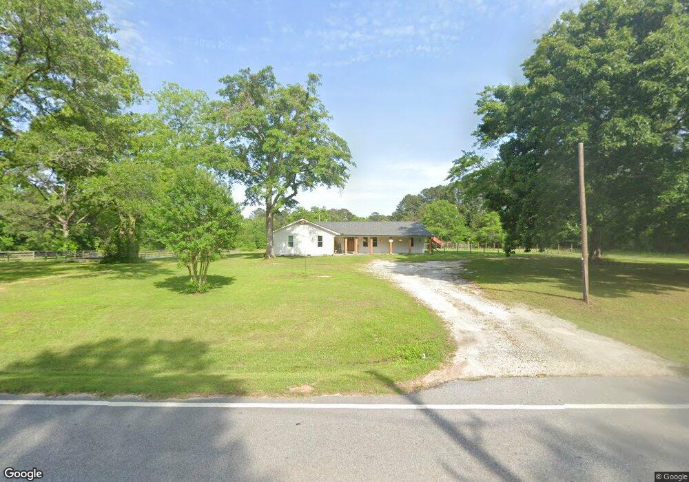
632 Tope Rd Sharpsburg, GA 30277
Estimated Value: $451,000 - $506,000
3
Beds
2
Baths
2,085
Sq Ft
$231/Sq Ft
Est. Value
About This Home
This home is located at 632 Tope Rd, Sharpsburg, GA 30277 and is currently estimated at $482,257, approximately $231 per square foot. 632 Tope Rd is a home located in Coweta County with nearby schools including Poplar Road Elementary School, East Coweta Middle School, and East Coweta High School.
Ownership History
Date
Name
Owned For
Owner Type
Purchase Details
Closed on
May 6, 2022
Sold by
Hannah Ray E
Bought by
Stapf Rilea
Current Estimated Value
Home Financials for this Owner
Home Financials are based on the most recent Mortgage that was taken out on this home.
Original Mortgage
$406,762
Outstanding Balance
$383,726
Interest Rate
4.67%
Mortgage Type
New Conventional
Estimated Equity
$98,531
Purchase Details
Closed on
Jul 16, 2007
Sold by
Thompson Richard A
Bought by
Hannah Ray E and Hannah Lori A
Purchase Details
Closed on
Apr 17, 1990
Sold by
Thompson Richard A
Bought by
Thompson Richard A
Purchase Details
Closed on
Dec 31, 1986
Bought by
Thompson Richard A
Create a Home Valuation Report for This Property
The Home Valuation Report is an in-depth analysis detailing your home's value as well as a comparison with similar homes in the area
Home Values in the Area
Average Home Value in this Area
Purchase History
| Date | Buyer | Sale Price | Title Company |
|---|---|---|---|
| Stapf Rilea | $385,000 | -- | |
| Hannah Ray E | $315,000 | -- | |
| Thompson Richard A | -- | -- | |
| Thompson Richard A | -- | -- |
Source: Public Records
Mortgage History
| Date | Status | Borrower | Loan Amount |
|---|---|---|---|
| Open | Stapf Rilea | $406,762 |
Source: Public Records
Tax History Compared to Growth
Tax History
| Year | Tax Paid | Tax Assessment Tax Assessment Total Assessment is a certain percentage of the fair market value that is determined by local assessors to be the total taxable value of land and additions on the property. | Land | Improvement |
|---|---|---|---|---|
| 2025 | $4,165 | $188,420 | $86,711 | $101,710 |
| 2024 | $3,314 | $147,361 | $47,579 | $99,782 |
| 2023 | $3,314 | $141,063 | $48,016 | $93,047 |
| 2022 | $3,018 | $122,516 | $43,651 | $78,865 |
| 2021 | $2,852 | $108,344 | $38,681 | $69,663 |
| 2020 | $2,871 | $108,344 | $38,681 | $69,663 |
| 2019 | $2,993 | $102,253 | $31,587 | $70,666 |
| 2018 | $2,998 | $102,253 | $31,587 | $70,666 |
| 2017 | $2,997 | $102,253 | $31,587 | $70,666 |
| 2016 | $2,961 | $102,253 | $31,587 | $70,666 |
| 2015 | $2,911 | $102,253 | $31,587 | $70,666 |
| 2014 | $2,913 | $102,253 | $31,587 | $70,666 |
Source: Public Records
Map
Nearby Homes
- 0 Cannon Rd Unit 7627017
- 0 Cannon Rd Unit 10566028
- 65 Oakhurst Trail
- 69 Oakhurst Trail
- 465 Little Rd
- 2812 Highway 16 E
- 565 Timberbrook Dr
- 46 Lullwater Ct
- 4083 Highway 54
- 165 Durham Estates Dr
- 49 Durham Estates Dr
- 2784 Martin Mill Rd
- 68 Winchester Dr
- 215 Grey Fairs Ave
- 2752 Poplar Rd
- 316 Winchester Dr
- 1948 Highway 16 E
- 98 Ryeland Dr
- 136 Ryeland Dr
- 143 Ryeland Dr