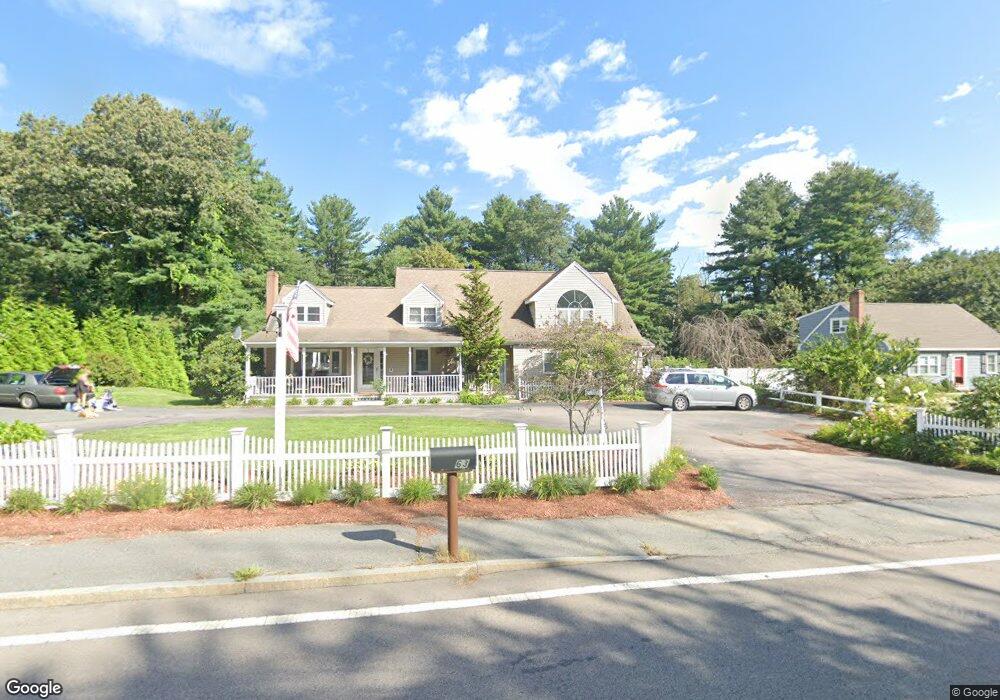
632 West St Wrentham, MA 02093
Sheldonville Neighborhood
4
Beds
4
Baths
3,756
Sq Ft
0.73
Acres
About This Home
This home is located at 632 West St, Wrentham, MA 02093. 632 West St is a home located in Norfolk County with nearby schools including Delaney Elementary School, Charles E Roderick, and Mercymount Country Day School.
Ownership History
Date
Name
Owned For
Owner Type
Purchase Details
Closed on
Oct 28, 2025
Sold by
Moore Patrick J and Moore Patricia S
Bought by
Moroe Rt and Moore
Purchase Details
Closed on
Dec 8, 1989
Sold by
Moore Jerome J
Bought by
Moore Patrick J
Home Financials for this Owner
Home Financials are based on the most recent Mortgage that was taken out on this home.
Original Mortgage
$105,000
Interest Rate
9.72%
Mortgage Type
Commercial
Create a Home Valuation Report for This Property
The Home Valuation Report is an in-depth analysis detailing your home's value as well as a comparison with similar homes in the area
Home Values in the Area
Average Home Value in this Area
Purchase History
| Date | Buyer | Sale Price | Title Company |
|---|---|---|---|
| Moroe Rt | -- | -- | |
| Moore Patrick J | $105,000 | -- | |
| Moore Patrick J | $105,000 | -- |
Source: Public Records
Mortgage History
| Date | Status | Borrower | Loan Amount |
|---|---|---|---|
| Previous Owner | Moore Patrick J | $30,000 | |
| Previous Owner | Moore Patrick J | $98,500 | |
| Previous Owner | Moore Patrick J | $105,000 |
Source: Public Records
Tax History Compared to Growth
Tax History
| Year | Tax Paid | Tax Assessment Tax Assessment Total Assessment is a certain percentage of the fair market value that is determined by local assessors to be the total taxable value of land and additions on the property. | Land | Improvement |
|---|---|---|---|---|
| 2025 | -- | $755,800 | $253,000 | $502,800 |
| 2024 | -- | $693,800 | $253,000 | $440,800 |
| 2023 | $0 | $649,800 | $230,100 | $419,700 |
| 2022 | $0 | $573,300 | $223,900 | $349,400 |
| 2021 | $0 | $541,800 | $209,200 | $332,600 |
| 2020 | $7,656 | $517,900 | $159,700 | $358,200 |
| 2019 | $0 | $484,200 | $143,700 | $340,500 |
| 2018 | $0 | $477,400 | $143,900 | $333,500 |
| 2017 | $0 | $466,000 | $141,100 | $324,900 |
| 2016 | -- | $459,700 | $137,000 | $322,700 |
| 2015 | -- | $441,000 | $146,400 | $294,600 |
| 2014 | -- | $428,300 | $140,800 | $287,500 |
Source: Public Records
Map
Nearby Homes
- 80 Carriage House Ln
- 50 Green St
- 440 Chestnut St
- 955 Summer St
- 19 Chestnut Lot 0
- 1204 South St
- 1222 South St
- 11 Amber Dr
- 791 South St Unit 5
- 4 Munroe Dr
- 12 Grant St
- 6 Woodchester Rd
- Lot 1 - Blueberry 2 Car Plan at King Philip Estates
- Lot 8 - Blueberry 2 Car Plan at King Philip Estates
- Lot 5 - Hughes 2 car Plan at King Philip Estates
- Lot 6 - Blueberry 3 Car Plan at King Philip Estates
- Lot 2 - Camden 2 Car Plan at King Philip Estates
- Lot 7 - Cedar Plan at King Philip Estates
- Lot 4 - Hemingway 2 Car Plan at King Philip Estates
- Lot 3 - Blueberry 2 Car Plan at King Philip Estates