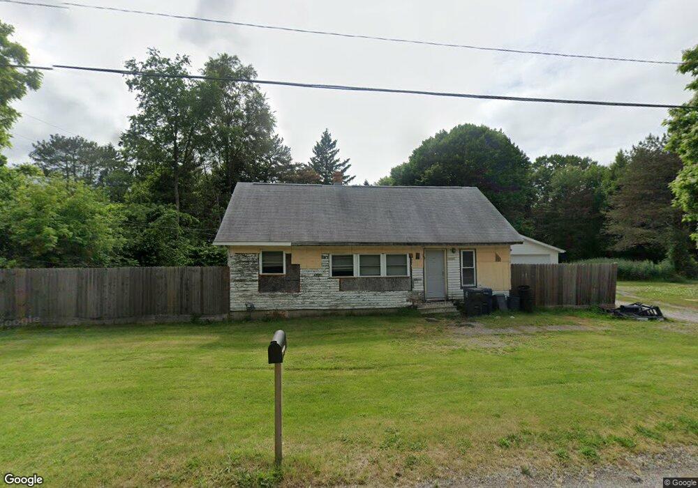
6325 Branch Rd Flint, MI 48506
Northeast Flint NeighborhoodEstimated Value: $59,000 - $101,000
2
Beds
1
Bath
1,198
Sq Ft
$68/Sq Ft
Est. Value
About This Home
This home is located at 6325 Branch Rd, Flint, MI 48506 and is currently estimated at $81,057, approximately $67 per square foot. 6325 Branch Rd is a home located in Genesee County with nearby schools including Brownell STEM Academy, Richfield Public School Academy, and Richfield Early Learning Center.
Ownership History
Date
Name
Owned For
Owner Type
Purchase Details
Closed on
Oct 13, 2020
Sold by
Hart Ashley
Bought by
Mailhot Timothy John and Kimmel Stephanie
Current Estimated Value
Purchase Details
Closed on
Dec 10, 2019
Sold by
Hart Ashley
Bought by
Mailhof Timothy and Kimmel Stephanie
Home Financials for this Owner
Home Financials are based on the most recent Mortgage that was taken out on this home.
Original Mortgage
$15,000
Interest Rate
3.6%
Mortgage Type
Land Contract Argmt. Of Sale
Purchase Details
Closed on
Oct 4, 2018
Sold by
Allison Joshua
Bought by
Hart Ashley
Purchase Details
Closed on
Feb 17, 2016
Sold by
Faith Tabernacle Church
Bought by
Allison Joshua
Purchase Details
Closed on
Oct 17, 2014
Sold by
Matthews J D
Bought by
Matthews J D
Purchase Details
Closed on
Mar 16, 2001
Sold by
Matthews Matthews J and Matthews Y
Bought by
Matthews J D and Matthews Barbara Jean
Create a Home Valuation Report for This Property
The Home Valuation Report is an in-depth analysis detailing your home's value as well as a comparison with similar homes in the area
Home Values in the Area
Average Home Value in this Area
Purchase History
| Date | Buyer | Sale Price | Title Company |
|---|---|---|---|
| Mailhot Timothy John | $5,000 | None Available | |
| Mailhof Timothy | $25,000 | First American Title Ins Co | |
| Hart Ashley | $2,500 | None Available | |
| Allison Joshua | $1,800 | Attorney | |
| Matthews J D | -- | None Available | |
| Matthews J D | -- | -- |
Source: Public Records
Mortgage History
| Date | Status | Borrower | Loan Amount |
|---|---|---|---|
| Previous Owner | Mailhof Timothy | $15,000 |
Source: Public Records
Tax History
| Year | Tax Paid | Tax Assessment Tax Assessment Total Assessment is a certain percentage of the fair market value that is determined by local assessors to be the total taxable value of land and additions on the property. | Land | Improvement |
|---|---|---|---|---|
| 2025 | $1,404 | $29,500 | $0 | $0 |
| 2024 | $1,294 | $25,700 | $0 | $0 |
| 2023 | $1,260 | $22,000 | $0 | $0 |
| 2022 | $0 | $17,400 | $0 | $0 |
| 2021 | $1,281 | $15,700 | $0 | $0 |
| 2020 | $1,172 | $13,800 | $0 | $0 |
| 2019 | $1,208 | $14,600 | $0 | $0 |
| 2018 | $921 | $10,600 | $0 | $0 |
| 2017 | $897 | $0 | $0 | $0 |
| 2016 | $660 | $0 | $0 | $0 |
| 2015 | -- | $0 | $0 | $0 |
| 2014 | -- | $0 | $0 | $0 |
| 2012 | -- | $11,800 | $0 | $0 |
Source: Public Records
Map
Nearby Homes
- 2919 Hampstead Dr
- 5919 Western Rd
- 2825 Eaton Place
- 2727 Eaton Place
- 4907 Delta Dr
- 4298 N Center Rd
- 3364 E Pierson Rd
- 5190 Branch Rd
- 1704 E Webster Rd
- 3456 E Pierson Rd
- 5910 N Dort Hwy
- 4141 Hidden View Dr
- 3294 Huggins Ave
- 4127 Coggins Ave
- 2935 Richfield Rd
- 00 Richfield Rd
- 1218 E Piper Ave
- E E Carpenter Rd
- 0 Sugar Maple Farms Unit 50195365
- 6101 Selby St
- 6315 Branch Rd
- 4264 Branch Rd
- 6481 Branch Rd
- 6511 Branch Rd
- 6507 Branch Rd
- G4342 Branch Rd
- G4326 Branch Rd
- G4358 Branch Rd
- G4314 Branch Rd
- 2905 Hampstead Dr
- 2901 Hampstead Dr
- 2909 Hampstead Dr
- 2849 Hampstead Dr
- 2913 Hampstead Dr
- 2845 Hampstead Dr
- 2841 Hampstead Dr
- 3001 Hampstead Dr
- 2837 Hampstead Dr
- 3007 Hampstead Dr
- 2833 Hampstead Dr
Your Personal Tour Guide
Ask me questions while you tour the home.