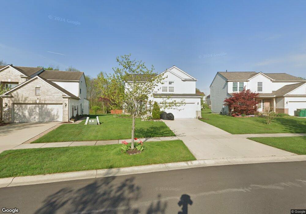
6326 Oakhurst Dr Ypsilanti, MI 48197
Estimated Value: $357,000 - $411,000
3
Beds
3
Baths
1,746
Sq Ft
$219/Sq Ft
Est. Value
About This Home
This home is located at 6326 Oakhurst Dr, Ypsilanti, MI 48197 and is currently estimated at $381,620, approximately $218 per square foot. 6326 Oakhurst Dr is a home located in Washtenaw County with nearby schools including Lincoln Senior High School, East Arbor Charter Academy, and Pittsfield Acres Academy.
Ownership History
Date
Name
Owned For
Owner Type
Purchase Details
Closed on
Oct 27, 2004
Sold by
Kantor Robert J and Kantos Lynn M
Bought by
Ervin Michael S and Clayborn Ervin Sharon D
Current Estimated Value
Home Financials for this Owner
Home Financials are based on the most recent Mortgage that was taken out on this home.
Original Mortgage
$170,000
Outstanding Balance
$85,231
Interest Rate
5.85%
Mortgage Type
Fannie Mae Freddie Mac
Estimated Equity
$296,389
Create a Home Valuation Report for This Property
The Home Valuation Report is an in-depth analysis detailing your home's value as well as a comparison with similar homes in the area
Home Values in the Area
Average Home Value in this Area
Purchase History
| Date | Buyer | Sale Price | Title Company |
|---|---|---|---|
| Ervin Michael S | $200,000 | Transnation Title Ins Co |
Source: Public Records
Mortgage History
| Date | Status | Borrower | Loan Amount |
|---|---|---|---|
| Open | Ervin Michael S | $170,000 |
Source: Public Records
Tax History Compared to Growth
Tax History
| Year | Tax Paid | Tax Assessment Tax Assessment Total Assessment is a certain percentage of the fair market value that is determined by local assessors to be the total taxable value of land and additions on the property. | Land | Improvement |
|---|---|---|---|---|
| 2025 | -- | $176,300 | $0 | $0 |
| 2024 | $2,833 | $161,500 | $0 | $0 |
| 2023 | $2,547 | $139,500 | $0 | $0 |
| 2022 | $2,431 | $124,800 | $0 | $0 |
| 2021 | $4,094 | $120,600 | $0 | $0 |
| 2020 | $4,042 | $112,600 | $0 | $0 |
| 2019 | $1,689 | $103,500 | $103,500 | $0 |
| 2018 | $0 | $92,700 | $0 | $0 |
| 2017 | $3,697 | $91,100 | $0 | $0 |
| 2016 | $2,239 | $76,925 | $0 | $0 |
| 2015 | $3,502 | $76,695 | $0 | $0 |
| 2014 | $3,502 | $74,300 | $0 | $0 |
| 2013 | -- | $74,300 | $0 | $0 |
Source: Public Records
Map
Nearby Homes
- 6447 Oakhurst Dr
- 6131 Creekside Cir
- 5193 Textile Rd
- 7435 Textile Rd
- 7363 Hideaway Dr
- 7109 Royal Troon Dr
- 7066 Streamwood Dr
- 8076 Pebblestone Dr
- 5696 Huntington Ct
- 7179 Streamwood Dr
- 8350 Thornhill Dr
- 5980 Pine View Dr
- 6935 Stony Creek Rd
- 8215 Hummingbird Dr
- 5593 N Eagle Ct
- 7184 Glacier Pointe Dr
- 7785 Dover Dr
- 7404 Dover Dr
- 8501 Martz Rd
- 7850 S Huron River Dr
- 6334 Oakhurst Dr
- 6318 Oakhurst Dr
- 6342 Oakhurst Dr
- 6310 Oakhurst Dr
- 6336 Oakbrook Dr
- 6344 Oakbrook Dr
- 6328 Oakbrook Dr
- 6350 Oakhurst Dr
- 6320 Oakbrook Dr
- 6327 Oakhurst Dr
- 7136 Oakridge Dr
- 6335 Oakhurst Dr
- 7148 Oakridge Dr
- 7124 Oakridge Dr
- 6319 Oakhurst Dr
- 6358 Oakhurst Dr
- 7112 Oakridge Dr
- 6311 Oakhurst Dr
- 0 Oakbrook Dr
- 7100 Oakridge Dr