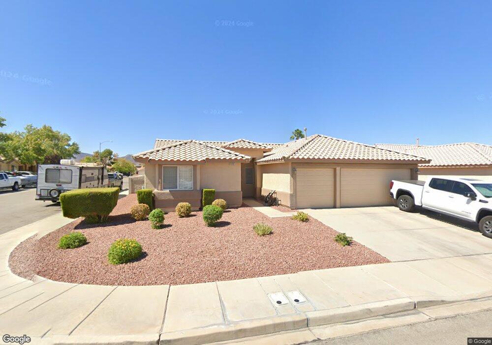
633 Brad St Henderson, NV 89015
River Mountain NeighborhoodEstimated Value: $431,975 - $453,000
3
Beds
2
Baths
1,592
Sq Ft
$280/Sq Ft
Est. Value
About This Home
This home is located at 633 Brad St, Henderson, NV 89015 and is currently estimated at $445,744, approximately $279 per square foot. 633 Brad St is a home located in Clark County with nearby schools including Sue H. Morrow Elementary School, B Mahlon Brown Academy of International Studies, and Basic Academy of International Studies.
Ownership History
Date
Name
Owned For
Owner Type
Purchase Details
Closed on
Jun 27, 2005
Sold by
Davis Thomas H and Davis Patricia N
Bought by
Gorsky Raymond W and Gorsky Vjalene R
Current Estimated Value
Home Financials for this Owner
Home Financials are based on the most recent Mortgage that was taken out on this home.
Original Mortgage
$295,000
Outstanding Balance
$149,953
Interest Rate
5.65%
Mortgage Type
Fannie Mae Freddie Mac
Estimated Equity
$295,791
Purchase Details
Closed on
Jun 12, 2000
Sold by
D R Horton Inc
Bought by
Davis Thomas H and Davis Patricia N
Home Financials for this Owner
Home Financials are based on the most recent Mortgage that was taken out on this home.
Original Mortgage
$138,494
Interest Rate
8.27%
Mortgage Type
VA
Create a Home Valuation Report for This Property
The Home Valuation Report is an in-depth analysis detailing your home's value as well as a comparison with similar homes in the area
Home Values in the Area
Average Home Value in this Area
Purchase History
| Date | Buyer | Sale Price | Title Company |
|---|---|---|---|
| Gorsky Raymond W | $312,000 | Ticor Title Of Nevada Inc | |
| Davis Thomas H | $134,461 | Old Republic Title Company |
Source: Public Records
Mortgage History
| Date | Status | Borrower | Loan Amount |
|---|---|---|---|
| Open | Gorsky Raymond W | $295,000 | |
| Previous Owner | Davis Thomas H | $138,494 |
Source: Public Records
Tax History
| Year | Tax Paid | Tax Assessment Tax Assessment Total Assessment is a certain percentage of the fair market value that is determined by local assessors to be the total taxable value of land and additions on the property. | Land | Improvement |
|---|---|---|---|---|
| 2026 | $1,782 | $104,085 | $38,150 | $65,935 |
| 2025 | $1,730 | $97,133 | $30,100 | $67,033 |
| 2024 | $1,680 | $97,133 | $30,100 | $67,033 |
| 2023 | $1,680 | $98,960 | $35,350 | $63,610 |
| 2022 | $1,631 | $88,588 | $30,450 | $58,138 |
| 2021 | $1,583 | $81,534 | $26,250 | $55,284 |
| 2020 | $1,534 | $79,327 | $24,500 | $54,827 |
| 2019 | $1,516 | $76,057 | $22,050 | $54,007 |
| 2018 | $1,446 | $69,585 | $17,500 | $52,085 |
| 2017 | $2,007 | $69,240 | $16,450 | $52,790 |
| 2016 | $1,355 | $62,589 | $9,800 | $52,789 |
| 2015 | $1,351 | $49,929 | $9,800 | $40,129 |
| 2014 | $1,312 | $45,356 | $8,400 | $36,956 |
Source: Public Records
Map
Nearby Homes
- 1073 Featherwood Ave
- 1044 Kennebunk Cir
- 717 Triple Crown St
- 727 Triple Crown St
- 626 Locust Grove St
- 1027 Huckburn Ave
- 1016 Huckburn Ave
- 1010 Huckburn Ave
- 1008 Beaver Crest Terrace
- 736 Spotted Eagle St Unit 2
- 1094 Langston Ranch Ave
- 573 Beryl Ct
- 698 S Racetrack Rd Unit 724
- 698 S Racetrack Rd Unit 1022
- 698 S Racetrack Rd Unit 1411
- 698 S Racetrack Rd Unit 1114
- 698 S Racetrack Rd Unit 1621
- 698 S Racetrack Rd Unit 713
- 596 Kenerly St
- 1109 Pincay Dr
- 631 Brad St
- 1072 Vanlier Ln
- 637 Brad St Unit 2
- 629 Brad St Unit 1
- 634 Brad St
- 1070 Vanlier Ln
- 1073 Vanlier Ln Unit none
- 1073 Vanlier Ln
- 636 Brad St
- 632 Brad St
- 1071 Deangelis Dr
- 639 Brad St
- 1071 Vanlier Ln
- 638 Brad St
- 630 Brad St
- 1068 Vanlier Ln
- 1069 Deangelis Dr
- 640 Brad St
- 1069 Vanlier Ln Unit SingleFamily
Your Personal Tour Guide
Ask me questions while you tour the home.