Estimated Value: $467,515 - $516,000
4
Beds
2
Baths
1,938
Sq Ft
$248/Sq Ft
Est. Value
About This Home
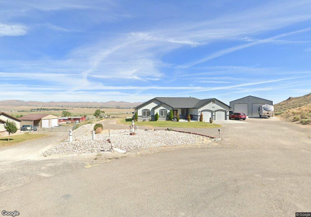
This home is located at 633 Dallin Ct, Elko, NV 89801 and is currently estimated at $480,879, approximately $248 per square foot. 633 Dallin Ct is a home with nearby schools including Southside Elementary School, Flagview Intermediate School, and Adobe Middle School.
Ownership History
Date
Name
Owned For
Owner Type
Purchase Details
Closed on
Mar 5, 2021
Sold by
Rooney Pamela M and Rooney Jody P
Bought by
Rooney Jody and Rooney Pamela
Current Estimated Value
Home Financials for this Owner
Home Financials are based on the most recent Mortgage that was taken out on this home.
Original Mortgage
$277,500
Outstanding Balance
$248,759
Interest Rate
2.7%
Mortgage Type
New Conventional
Estimated Equity
$232,120
Purchase Details
Closed on
Oct 27, 2014
Sold by
Arnold Beck Construction Inc
Bought by
Scates Pamela M and Rooney Jody P
Home Financials for this Owner
Home Financials are based on the most recent Mortgage that was taken out on this home.
Original Mortgage
$228,900
Interest Rate
4.1%
Mortgage Type
New Conventional
Purchase Details
Closed on
Mar 26, 2014
Sold by
Jordanelle Third Mortgage L L C
Bought by
Arnold Beck Construction Inc
Create a Home Valuation Report for This Property
The Home Valuation Report is an in-depth analysis detailing your home's value as well as a comparison with similar homes in the area
Purchase History
| Date | Buyer | Sale Price | Title Company |
|---|---|---|---|
| Rooney Jody | -- | Stewart Title Elko | |
| Scates Pamela M | $299,000 | First American Title Elko | |
| Arnold Beck Construction Inc | $480,000 | First American Title Elko |
Source: Public Records
Mortgage History
| Date | Status | Borrower | Loan Amount |
|---|---|---|---|
| Open | Rooney Jody | $277,500 | |
| Closed | Scates Pamela M | $228,900 |
Source: Public Records
Tax History
| Year | Tax Paid | Tax Assessment Tax Assessment Total Assessment is a certain percentage of the fair market value that is determined by local assessors to be the total taxable value of land and additions on the property. | Land | Improvement |
|---|---|---|---|---|
| 2025 | $3,816 | $149,378 | $19,250 | $130,128 |
| 2024 | $3,816 | $152,480 | $19,250 | $133,230 |
| 2023 | $3,409 | $142,785 | $19,250 | $123,535 |
| 2022 | $3,310 | $123,571 | $19,250 | $104,321 |
| 2021 | $3,439 | $120,381 | $19,250 | $101,131 |
| 2020 | $2,956 | $108,294 | $21,700 | $86,594 |
| 2019 | $2,853 | $101,053 | $14,000 | $87,053 |
| 2018 | $2,843 | $101,073 | $14,000 | $87,073 |
| 2017 | $2,543 | $99,224 | $14,000 | $85,224 |
| 2016 | $2,413 | $92,866 | $14,000 | $78,866 |
| 2015 | $2,380 | $13,125 | $13,125 | $0 |
| 2014 | $337 | $13,125 | $13,125 | $0 |
Source: Public Records
Map
Nearby Homes
- 1075 Amber Way
- 1151 Amber Way
- 1014 Amber Way
- TBD Amber Way
- 0 Amber Way
- 376 Four Mile Trail
- 0 Hamilton Creek Trail
- TBD Hamilton Creek Trail
- 7270 Adams St
- 3500 W Idaho St
- 0 2nd St
- 1451 Jennings Ct
- 0 3rd St
- 0 Washington Ave
- 353 New Pine St
- 0 S 5th St
- 2880 Jennings Way
- 5731 Sulphur Spring St
- 0 Elko Summit Dr Unit 3620547
- 345 Fir St
Your Personal Tour Guide
Ask me questions while you tour the home.