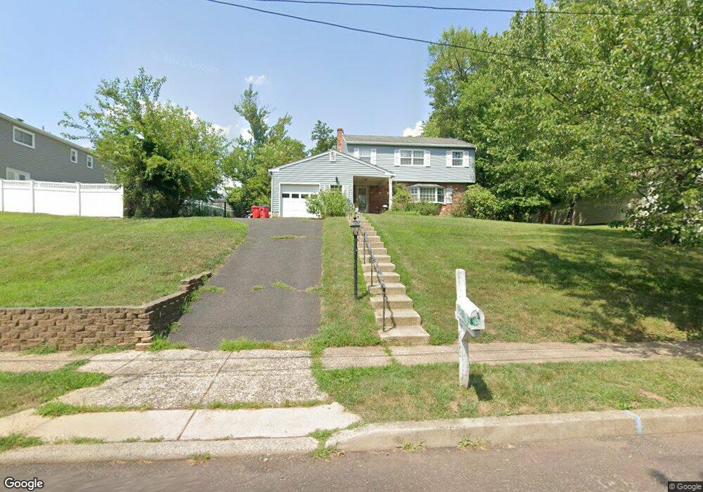
633 Mockingbird Ln Norristown, PA 19403
Estimated Value: $567,271 - $612,000
4
Beds
3
Baths
2,256
Sq Ft
$264/Sq Ft
Est. Value
About This Home
This home is located at 633 Mockingbird Ln, Norristown, PA 19403 and is currently estimated at $596,568, approximately $264 per square foot. 633 Mockingbird Ln is a home located in Montgomery County with nearby schools including Woodland Elementary School, Skyview Upper Elementary School, and Arcola Intermediate School.
Ownership History
Date
Name
Owned For
Owner Type
Purchase Details
Closed on
Jan 24, 2025
Sold by
Marion Peter J and Marion Diane D
Bought by
Marion Diane D
Current Estimated Value
Home Financials for this Owner
Home Financials are based on the most recent Mortgage that was taken out on this home.
Original Mortgage
$381,562
Outstanding Balance
$379,210
Interest Rate
6.72%
Mortgage Type
FHA
Estimated Equity
$217,358
Purchase Details
Closed on
Jun 30, 2008
Sold by
Vibbert Nancy Lynn and Vibbert Frank M
Bought by
Marion Diane D and Marion Peter J
Home Financials for this Owner
Home Financials are based on the most recent Mortgage that was taken out on this home.
Original Mortgage
$276,000
Interest Rate
6.13%
Create a Home Valuation Report for This Property
The Home Valuation Report is an in-depth analysis detailing your home's value as well as a comparison with similar homes in the area
Home Values in the Area
Average Home Value in this Area
Purchase History
| Date | Buyer | Sale Price | Title Company |
|---|---|---|---|
| Marion Diane D | -- | Germantown Title | |
| Marion Diane D | -- | Germantown Title | |
| Marion Diane D | $345,000 | None Available |
Source: Public Records
Mortgage History
| Date | Status | Borrower | Loan Amount |
|---|---|---|---|
| Open | Marion Diane D | $381,562 | |
| Closed | Marion Diane D | $381,562 | |
| Previous Owner | Marion Diane D | $276,000 |
Source: Public Records
Tax History Compared to Growth
Tax History
| Year | Tax Paid | Tax Assessment Tax Assessment Total Assessment is a certain percentage of the fair market value that is determined by local assessors to be the total taxable value of land and additions on the property. | Land | Improvement |
|---|---|---|---|---|
| 2025 | $6,522 | $159,910 | $52,210 | $107,700 |
| 2024 | $6,522 | $159,910 | $52,210 | $107,700 |
| 2023 | $6,275 | $159,910 | $52,210 | $107,700 |
| 2022 | $6,103 | $159,910 | $52,210 | $107,700 |
| 2021 | $5,946 | $159,910 | $52,210 | $107,700 |
| 2020 | $5,807 | $159,910 | $52,210 | $107,700 |
| 2019 | $5,753 | $159,910 | $52,210 | $107,700 |
| 2018 | $5,753 | $159,910 | $52,210 | $107,700 |
| 2017 | $5,494 | $159,910 | $52,210 | $107,700 |
| 2016 | $5,432 | $159,910 | $52,210 | $107,700 |
| 2015 | $5,220 | $159,910 | $52,210 | $107,700 |
| 2014 | $5,220 | $159,910 | $52,210 | $107,700 |
Source: Public Records
Map
Nearby Homes
- 617 Meadowlark Rd
- 3026 Highley Rd
- 35 Buckwalter Rd
- 1102 Redtail Rd
- LOT 24 Egypt Rd
- 123 Glenwood Ave
- 2825 Egypt Rd
- 106 Glenwood Ave
- 636 Hillside Ave
- 18 Pheasant Rd
- 308 Hillside Ave
- 2016 Bayless Place Unit CONDO Q-4
- 0 Roosevelt Blvd
- 2044 Mill Rd
- 1503 Reagan Ct
- Laney Craftsman
- 11 Pershing Ave
- 109 N Park Ave
- 2504 Grant Ct
- 12 Wilson Blvd
- 629 Mockingbird Ln
- 637 Mockingbird Ln
- 625 Mockingbird Ln
- 624 Mourning Dove Rd
- 628 Mourning Dove Rd
- 624 Mockingbird Ln
- 701 Mockingbird Ln
- 628 Mockingbird Ln
- 616 Mourning Dove Rd
- 621 Mockingbird Ln
- 620 Mockingbird Ln
- 632 Mockingbird Ln
- 616 Mockingbird Ln
- 700 Mourning Dove Rd
- 612 Mourning Dove Rd
- 705 Mockingbird Ln
- 700 Mockingbird Ln
- 617 Mockingbird Ln
- 612 Mockingbird Ln
- 102 Mallard Cir