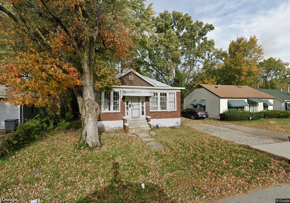
633 N 81st St East Saint Louis, IL 62203
Estimated Value: $19,000 - $52,000
--
Bed
--
Bath
1,232
Sq Ft
$34/Sq Ft
Est. Value
About This Home
This home is located at 633 N 81st St, East Saint Louis, IL 62203 and is currently estimated at $41,295, approximately $33 per square foot. 633 N 81st St is a home located in St. Clair County with nearby schools including Katie Harper-Wright Elementary School, Mason/Clark Middle School, and East St Louis Senior High School.
Ownership History
Date
Name
Owned For
Owner Type
Purchase Details
Closed on
Apr 1, 2025
Sold by
Riverfront Corp
Bought by
Williams Terrence D and Williams Terrence D
Current Estimated Value
Purchase Details
Closed on
Feb 22, 2021
Sold by
Riverfront Corp
Bought by
Williams Terrence
Purchase Details
Closed on
Dec 31, 2014
Sold by
E & W Gateways Inc
Bought by
Riverfront Corporation
Purchase Details
Closed on
Sep 29, 2010
Sold by
County Of Saint Clair
Bought by
E & W Gateways Inc
Purchase Details
Closed on
Jul 27, 2010
Sold by
Benson and Cholet
Bought by
County Of Saint Clair
Create a Home Valuation Report for This Property
The Home Valuation Report is an in-depth analysis detailing your home's value as well as a comparison with similar homes in the area
Home Values in the Area
Average Home Value in this Area
Purchase History
| Date | Buyer | Sale Price | Title Company |
|---|---|---|---|
| Williams Terrence D | $18,000 | None Available | |
| Williams Terrence | -- | None Available | |
| Riverfront Corporation | -- | None Available | |
| E & W Gateways Inc | -- | None Available | |
| County Of Saint Clair | -- | None Available |
Source: Public Records
Tax History Compared to Growth
Tax History
| Year | Tax Paid | Tax Assessment Tax Assessment Total Assessment is a certain percentage of the fair market value that is determined by local assessors to be the total taxable value of land and additions on the property. | Land | Improvement |
|---|---|---|---|---|
| 2024 | $1,562 | $11,718 | $1,415 | $10,303 |
| 2023 | $1,432 | $10,409 | $1,257 | $9,152 |
| 2022 | $738 | $5,332 | $1,160 | $4,172 |
| 2021 | $718 | $5,044 | $1,097 | $3,947 |
| 2020 | $761 | $5,121 | $1,114 | $4,007 |
| 2019 | $811 | $5,121 | $1,114 | $4,007 |
| 2018 | $539 | $3,222 | $1,107 | $2,115 |
| 2017 | $541 | $3,178 | $1,092 | $2,086 |
| 2016 | $543 | $3,190 | $1,096 | $2,094 |
| 2014 | $510 | $3,470 | $316 | $3,154 |
| 2013 | $512 | $3,560 | $324 | $3,236 |
Source: Public Records
Map
Nearby Homes
- 546 N 81st St
- 839 N 82nd St
- 462 N 83rd St
- 0 Rogers St Unit MAR24076886
- 861 Pershing Blvd
- 659 N 70th St
- 6814 State St
- 837 N 70th St
- 6 Hilltop Place
- 38 Granvue Dr
- 14 Granvue Dr
- 11 Calhoun Ln
- 1428 1st Ave
- 100 S 98th St
- 6801 Lake Dr
- 212 Woodcrest Dr
- 1226 N 71st St
- 1619 Pontiac Rd
- 80 N 98th St
- 24 S 95th St