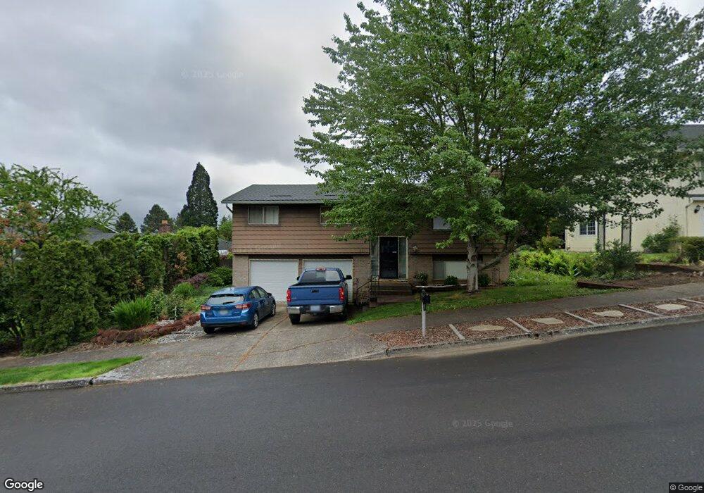
633 SW 7th St Gresham, OR 97080
Gresham Butte NeighborhoodEstimated Value: $463,000 - $507,000
3
Beds
3
Baths
1,752
Sq Ft
$277/Sq Ft
Est. Value
About This Home
This home is located at 633 SW 7th St, Gresham, OR 97080 and is currently estimated at $485,436, approximately $277 per square foot. 633 SW 7th St is a home located in Multnomah County with nearby schools including Dexter McCarty Middle School, Gresham High School, and Gresham Arthur Academy.
Ownership History
Date
Name
Owned For
Owner Type
Purchase Details
Closed on
Oct 25, 2002
Sold by
Wells Fargo Financial Oregon Inc
Bought by
Kitchen Julian B and Kitchen Lisa M
Current Estimated Value
Home Financials for this Owner
Home Financials are based on the most recent Mortgage that was taken out on this home.
Original Mortgage
$170,917
Outstanding Balance
$70,616
Interest Rate
6.09%
Mortgage Type
FHA
Estimated Equity
$414,820
Purchase Details
Closed on
Apr 5, 2002
Sold by
Frey Rexford G
Bought by
Wells Fargo Financial Oregon Inc
Create a Home Valuation Report for This Property
The Home Valuation Report is an in-depth analysis detailing your home's value as well as a comparison with similar homes in the area
Home Values in the Area
Average Home Value in this Area
Purchase History
| Date | Buyer | Sale Price | Title Company |
|---|---|---|---|
| Kitchen Julian B | $173,600 | Transnation Title Insurance | |
| Wells Fargo Financial Oregon Inc | -- | -- |
Source: Public Records
Mortgage History
| Date | Status | Borrower | Loan Amount |
|---|---|---|---|
| Open | Kitchen Julian B | $170,917 |
Source: Public Records
Tax History
| Year | Tax Paid | Tax Assessment Tax Assessment Total Assessment is a certain percentage of the fair market value that is determined by local assessors to be the total taxable value of land and additions on the property. | Land | Improvement |
|---|---|---|---|---|
| 2025 | $5,371 | $263,960 | -- | -- |
| 2024 | $5,142 | $256,280 | -- | -- |
| 2023 | $4,685 | $248,820 | $0 | $0 |
| 2022 | $4,554 | $241,580 | $0 | $0 |
| 2021 | $4,439 | $234,550 | $0 | $0 |
| 2020 | $4,177 | $227,720 | $0 | $0 |
| 2019 | $4,067 | $221,090 | $0 | $0 |
| 2018 | $3,878 | $214,660 | $0 | $0 |
| 2017 | $3,721 | $208,410 | $0 | $0 |
| 2016 | $3,281 | $202,340 | $0 | $0 |
Source: Public Records
Map
Nearby Homes
- 638 SW 7th St
- 419 SW Day Ct
- 645 W Powell Blvd
- 159 SW Florence Ave Unit 64
- 159 SW Florence Ave
- 625 SW Miller Ct
- 1113 W Powell Blvd
- 1434 SW 5th Place
- 1407 SW Walters Dr
- 415 SE Roberts Ave
- 417 SE Roberts Ave
- 55 SW Lovhar Dr
- 1175 SW Chastain Dr
- 0 SW Miller Ct Unit 470855683
- 318 NE Roberts Ave Unit 308
- 318 NE Roberts Ave Unit 203
- 0 NE 5th St
- 44 SW Birdsdale Dr
- 994 NW Wallula Ave
- 511 SE 15th St
Your Personal Tour Guide
Ask me questions while you tour the home.