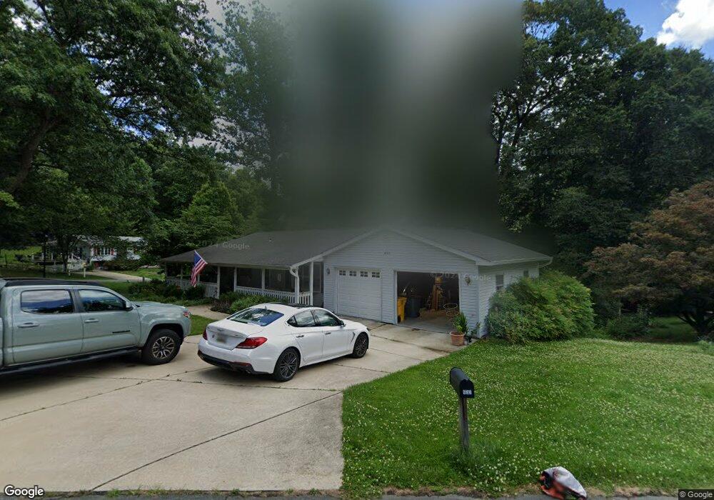
633 Wayward Dr Annapolis, MD 21401
Parole NeighborhoodEstimated Value: $481,437 - $565,000
Studio
2
Baths
1,320
Sq Ft
$400/Sq Ft
Est. Value
About This Home
This home is located at 633 Wayward Dr, Annapolis, MD 21401 and is currently estimated at $527,859, approximately $399 per square foot. 633 Wayward Dr is a home located in Anne Arundel County with nearby schools including Rolling Knolls Elementary School, Wiley H. Bates Middle School, and Annapolis High School.
Ownership History
Date
Name
Owned For
Owner Type
Purchase Details
Closed on
Mar 30, 2024
Sold by
Huffman Dean R
Bought by
Dean Huffman Family Trust and Huffman
Current Estimated Value
Purchase Details
Closed on
Oct 16, 2009
Sold by
Huffman Dean R
Bought by
Huffman Dean R
Purchase Details
Closed on
Jun 11, 1999
Sold by
Maynard Evan P
Bought by
Huffman Dean R and Huffman Sandra L
Purchase Details
Closed on
Apr 3, 1992
Sold by
Baillieul Keith E
Bought by
Maynard Evan P
Home Financials for this Owner
Home Financials are based on the most recent Mortgage that was taken out on this home.
Original Mortgage
$96,900
Interest Rate
8.96%
Create a Home Valuation Report for This Property
The Home Valuation Report is an in-depth analysis detailing your home's value as well as a comparison with similar homes in the area
Home Values in the Area
Average Home Value in this Area
Purchase History
| Date | Buyer | Sale Price | Title Company |
|---|---|---|---|
| Dean Huffman Family Trust | -- | None Listed On Document | |
| Huffman Dean R | -- | -- | |
| Huffman Dean R | $199,500 | -- | |
| Maynard Evan P | $176,900 | -- |
Source: Public Records
Mortgage History
| Date | Status | Borrower | Loan Amount |
|---|---|---|---|
| Previous Owner | Maynard Evan P | $96,900 | |
| Closed | Huffman Dean R | -- |
Source: Public Records
Tax History
| Year | Tax Paid | Tax Assessment Tax Assessment Total Assessment is a certain percentage of the fair market value that is determined by local assessors to be the total taxable value of land and additions on the property. | Land | Improvement |
|---|---|---|---|---|
| 2025 | $3,606 | $420,200 | -- | -- |
| 2024 | $3,606 | $402,000 | -- | -- |
| 2023 | $3,497 | $383,800 | $215,400 | $168,400 |
| 2022 | $3,278 | $380,733 | $0 | $0 |
| 2020 | $3,136 | $374,600 | $215,400 | $159,200 |
| 2019 | $3,082 | $365,267 | $0 | $0 |
| 2018 | $3,609 | $355,933 | $0 | $0 |
| 2017 | $2,903 | $346,600 | $0 | $0 |
| 2016 | -- | $338,300 | $0 | $0 |
| 2015 | -- | $330,000 | $0 | $0 |
| 2014 | -- | $321,700 | $0 | $0 |
Source: Public Records
Map
Nearby Homes
- 524 Ridge Rd
- 810 Midship Ct
- 807 Eastern Point Rd
- 1909 Eleanor Ct
- 2572 Golfers Ridge Rd
- 1002 Covington Way
- 1907 Mackiebeth Ct
- 208 Sellew Rd
- 108 Sellew Rd
- 109 Sellew Rd
- 553 Choptank Cove Ct
- 301 Unity Ln
- 803 Coxswain Way Unit 203
- 2510 Painter Ct
- 1945 Marconi Cir
- 1955 Marconi Cir
- 934 Chesterfield Rd
- 1976 Scotts Crossing Way Unit 1
- 1915 Towne Centre Blvd Unit 1001
- 1915 Towne Centre Blvd Unit 301
- 635 Wayward Dr
- 2173 Glenfield Rd
- 629 Wayward Dr
- 2176 Glenfield Rd
- 632 Wayward Dr
- 636 Wayward Dr
- 637 Wayward Dr
- 2178 Glenfield Rd
- 627 Wayward Dr
- 638 Wayward Dr
- 630 Wayward Dr
- 2180 Glenfield Rd
- 2177 Glenfield Rd
- 625 Wayward Dr
- 639 Wayward Dr
- 628 Wayward Dr
- 640 Wayward Dr
- 626 Wayward Dr
- 641 Wayward Dr
- 2179 Glenfield Rd
Your Personal Tour Guide
Ask me questions while you tour the home.