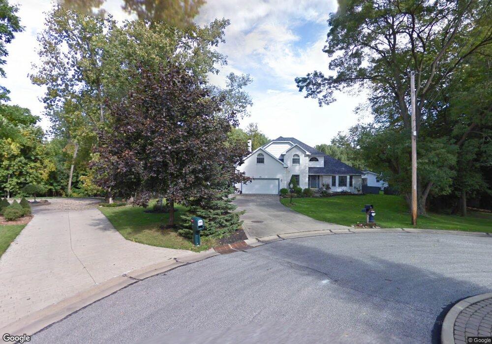
6339 Poplar Dr Independence, OH 44131
Estimated Value: $454,000 - $610,000
4
Beds
3
Baths
2,726
Sq Ft
$187/Sq Ft
Est. Value
About This Home
This home is located at 6339 Poplar Dr, Independence, OH 44131 and is currently estimated at $510,499, approximately $187 per square foot. 6339 Poplar Dr is a home located in Cuyahoga County with nearby schools including Independence Primary School, Independence Middle School, and Independence High School.
Ownership History
Date
Name
Owned For
Owner Type
Purchase Details
Closed on
Jan 7, 1999
Sold by
Sixta Robert A
Bought by
Sixta Darlene A
Current Estimated Value
Purchase Details
Closed on
Sep 30, 1991
Sold by
Sourek Doris M
Bought by
Sixta Robert A
Purchase Details
Closed on
Jan 1, 1987
Bought by
Sourek Doris M
Create a Home Valuation Report for This Property
The Home Valuation Report is an in-depth analysis detailing your home's value as well as a comparison with similar homes in the area
Home Values in the Area
Average Home Value in this Area
Purchase History
| Date | Buyer | Sale Price | Title Company |
|---|---|---|---|
| Sixta Darlene A | -- | -- | |
| Sixta Robert A | $50,000 | -- | |
| Sourek Doris M | -- | -- |
Source: Public Records
Tax History
| Year | Tax Paid | Tax Assessment Tax Assessment Total Assessment is a certain percentage of the fair market value that is determined by local assessors to be the total taxable value of land and additions on the property. | Land | Improvement |
|---|---|---|---|---|
| 2024 | $7,693 | $160,860 | $25,130 | $135,730 |
| 2023 | $7,018 | $133,320 | $23,840 | $109,480 |
| 2022 | $6,980 | $133,320 | $23,840 | $109,480 |
| 2021 | $6,878 | $133,320 | $23,840 | $109,480 |
| 2020 | $6,726 | $122,330 | $21,880 | $100,450 |
| 2019 | $6,493 | $349,500 | $62,500 | $287,000 |
| 2018 | $6,551 | $122,330 | $21,880 | $100,450 |
| 2017 | $5,874 | $105,710 | $18,030 | $87,680 |
| 2016 | $5,815 | $105,710 | $18,030 | $87,680 |
| 2015 | $5,810 | $105,710 | $18,030 | $87,680 |
| 2014 | $5,810 | $105,710 | $18,030 | $87,680 |
Source: Public Records
Map
Nearby Homes
- 0 Acorn Dr Unit 5023848
- 0 Daisy Blvd
- 6473 Tanglewood Ln
- 0 Brecksville Rd
- 1026 Joy Oval
- 6258 Carlyle Dr
- 6990 S Great Oaks Pkwy
- 5770 N Crossview Rd
- 5981 Northview Dr
- 423 E Decker Dr
- VL Laura Lee Ln
- VL TBB Laura Lee Ln
- 1329 E Schaaf Rd
- 8420 Stone Rd
- 872 E Dawnwood Dr
- 100 E Decker Dr
- 5658 N Circle View Dr
- 1196 N Skyline Dr
- 1093 E Schaaf Rd
- 916 Clearview Ave
- 6340 Poplar Dr
- 6349 Poplar Dr
- 6359 Poplar Dr
- 6344 Poplar Dr
- 6346 Poplar Dr
- 6348 Poplar Dr
- 4911 W Ash Rd
- 4915 W Ash Rd
- 4925 W Ash Rd
- 5017 W Ash Rd
- 6366 Poplar Dr
- 5151 W Ash Rd
- 6347 Pebblecreek Dr
- 6376 Poplar Dr
- 5199 W Ash Rd
- 6359 Pebblecreek Dr
- 6386 Poplar Dr
- 4912 W Ash Rd
- 4549 Cliffview Dr
- 4914 W Ash Rd
Your Personal Tour Guide
Ask me questions while you tour the home.