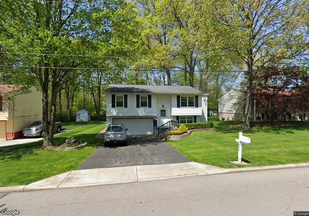
634 Cedar Dr Cortland, OH 44410
Estimated Value: $176,229 - $209,000
3
Beds
2
Baths
1,408
Sq Ft
$140/Sq Ft
Est. Value
About This Home
This home is located at 634 Cedar Dr, Cortland, OH 44410 and is currently estimated at $197,057, approximately $139 per square foot. 634 Cedar Dr is a home located in Trumbull County with nearby schools including Lakeview Elementary School, Lakeview Middle School, and Lakeview High School.
Ownership History
Date
Name
Owned For
Owner Type
Purchase Details
Closed on
Apr 20, 2010
Sold by
Abbuhl Duane L
Bought by
Abbuhl Duane L and Mcelhaney Jonathon
Current Estimated Value
Purchase Details
Closed on
Apr 8, 2010
Sold by
Fannie Mae
Bought by
Abbuhl Duane L
Purchase Details
Closed on
Sep 17, 2009
Sold by
Samu Matthew J
Bought by
Federal National Mortgage Association
Purchase Details
Closed on
Dec 21, 2005
Sold by
Klein Lillian and Klein Albert W
Bought by
Samu Matthew J
Purchase Details
Closed on
Nov 11, 2005
Sold by
Klein Lillian and Klein Albert W
Bought by
Samu Matthew J
Purchase Details
Closed on
Jun 21, 2001
Sold by
Klein Lillian
Bought by
Klein Albert W and Klein Cynthia D
Purchase Details
Closed on
Jan 1, 1990
Bought by
Albert and Albert Lillian
Create a Home Valuation Report for This Property
The Home Valuation Report is an in-depth analysis detailing your home's value as well as a comparison with similar homes in the area
Home Values in the Area
Average Home Value in this Area
Purchase History
| Date | Buyer | Sale Price | Title Company |
|---|---|---|---|
| Abbuhl Duane L | -- | Attorney | |
| Abbuhl Duane L | $54,600 | Accutitle Agency Inc | |
| Federal National Mortgage Association | $55,000 | None Available | |
| Samu Matthew J | $81,400 | -- | |
| Samu Matthew J | $81,400 | -- | |
| Klein Albert W | -- | -- | |
| Albert | -- | -- |
Source: Public Records
Mortgage History
| Date | Status | Borrower | Loan Amount |
|---|---|---|---|
| Closed | Samu Matthew J | -- |
Source: Public Records
Tax History Compared to Growth
Tax History
| Year | Tax Paid | Tax Assessment Tax Assessment Total Assessment is a certain percentage of the fair market value that is determined by local assessors to be the total taxable value of land and additions on the property. | Land | Improvement |
|---|---|---|---|---|
| 2024 | $2,363 | $44,980 | $6,060 | $38,920 |
| 2023 | $2,363 | $44,980 | $6,060 | $38,920 |
| 2022 | $1,973 | $31,470 | $6,060 | $25,410 |
| 2021 | $1,981 | $31,470 | $6,060 | $25,410 |
| 2020 | $1,991 | $31,470 | $6,060 | $25,410 |
| 2019 | $1,698 | $26,220 | $6,060 | $20,160 |
| 2018 | $1,706 | $26,220 | $6,060 | $20,160 |
| 2017 | $1,704 | $26,220 | $6,060 | $20,160 |
| 2016 | $1,297 | $19,290 | $6,060 | $13,230 |
| 2015 | $1,292 | $19,290 | $6,060 | $13,230 |
| 2014 | $1,136 | $19,290 | $6,060 | $13,230 |
| 2013 | $1,156 | $19,290 | $6,060 | $13,230 |
Source: Public Records
Map
Nearby Homes
- 140 Leckrone Way
- 105 Diamond Way Unit 105
- 104 Diamond Way Unit 104
- 111 Emerald Ln
- 151 Cedar Cir
- 130 Topaz Trail Unit 130
- 232 Bayview Dr Unit 232
- 19 Spring Creek Dr
- 220 Wae Trail
- 10 Harneds Landing
- 278 Rosewae Ave
- 3 Harneds Landing Unit 3
- 2 Harneds Landing
- 2730 Wilson Sharpsville Rd
- 2559 Wilson Sharpsville Rd
- 155 Heritage Ln
- 120 Winter Ln
- 2 Turnberry Place
- 0 N High St
- 3233 Niles Cortland Rd NE