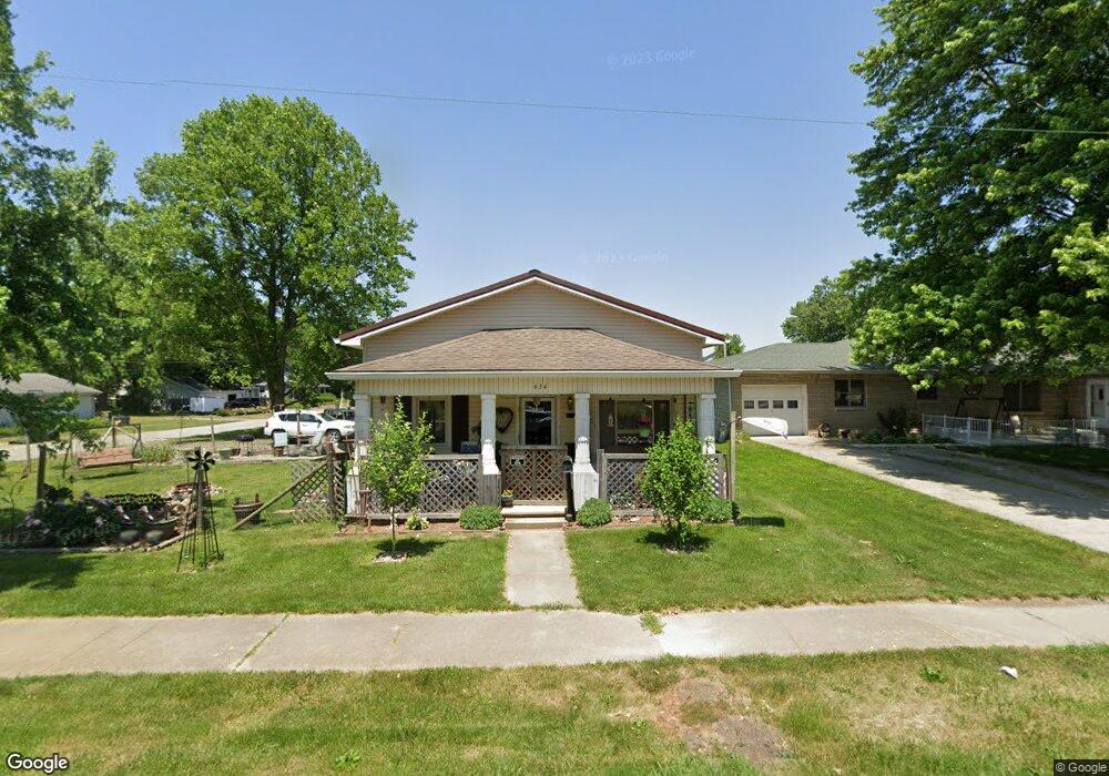
634 W Main St Thorntown, IN 46071
Estimated Value: $96,000 - $172,000
3
Beds
1
Bath
1,040
Sq Ft
$139/Sq Ft
Est. Value
About This Home
This home is located at 634 W Main St, Thorntown, IN 46071 and is currently estimated at $145,046, approximately $139 per square foot. 634 W Main St is a home located in Boone County with nearby schools including Western Boone Junior/Senior High School.
Ownership History
Date
Name
Owned For
Owner Type
Purchase Details
Closed on
Jul 23, 2021
Sold by
Pike Houston Kathy A and Lary J Houston Est
Bought by
Pikk Houston Kathy A
Current Estimated Value
Purchase Details
Closed on
Jul 28, 2020
Sold by
Keystone Karen Niemeyer and Trudie J Dillon Trust
Bought by
Houston Lary J
Purchase Details
Closed on
Jul 23, 2014
Sold by
Niemeyer Karen K
Bought by
Karen Niemeyer Keystone Trust
Purchase Details
Closed on
Sep 29, 2011
Sold by
Martin Sally and Skow Randolph
Bought by
Niemeyer Karen K
Purchase Details
Closed on
Mar 18, 2011
Sold by
Martin Sally
Bought by
Martin Sally and Kow Randoph S
Purchase Details
Closed on
May 10, 2010
Sold by
Martin Robert Dewayne
Bought by
Martin Sally Lee and Martin Robert Dewayne
Create a Home Valuation Report for This Property
The Home Valuation Report is an in-depth analysis detailing your home's value as well as a comparison with similar homes in the area
Home Values in the Area
Average Home Value in this Area
Purchase History
| Date | Buyer | Sale Price | Title Company |
|---|---|---|---|
| Pikk Houston Kathy A | -- | None Available | |
| Houston Lary J | -- | None Available | |
| Karen Niemeyer Keystone Trust | -- | None Available | |
| Niemeyer Karen K | -- | -- | |
| Martin Sally | -- | -- | |
| Martin Sally Lee | -- | -- |
Source: Public Records
Tax History Compared to Growth
Tax History
| Year | Tax Paid | Tax Assessment Tax Assessment Total Assessment is a certain percentage of the fair market value that is determined by local assessors to be the total taxable value of land and additions on the property. | Land | Improvement |
|---|---|---|---|---|
| 2025 | $509 | $102,500 | $14,300 | $88,200 |
| 2024 | $509 | $96,700 | $14,300 | $82,400 |
| 2023 | $442 | $89,500 | $14,300 | $75,200 |
| 2022 | $461 | $84,700 | $14,300 | $70,400 |
| 2021 | $373 | $73,700 | $14,300 | $59,400 |
| 2020 | $352 | $70,000 | $14,300 | $55,700 |
| 2019 | $337 | $68,200 | $14,300 | $53,900 |
| 2018 | $320 | $65,500 | $14,300 | $51,200 |
| 2017 | $296 | $61,800 | $14,300 | $47,500 |
| 2016 | $267 | $58,200 | $14,300 | $43,900 |
| 2014 | $245 | $53,500 | $14,300 | $39,200 |
| 2013 | $1,004 | $53,500 | $14,300 | $39,200 |
Source: Public Records
Map
Nearby Homes
- 223 S West St
- 117 N Market St
- 1323 Locust Place
- 1321 Locust Place
- 328 N Front St
- Ironwood Plan at Northwood Haven
- Spruce Plan at Northwood Haven
- Ashton Plan at Northwood Haven
- Palmetto Plan at Northwood Haven
- Bradford Plan at Northwood Haven
- Aspen II Plan at Northwood Haven
- Empress Plan at Northwood Haven
- Juniper Plan at Northwood Haven
- Chestnut Plan at Northwood Haven
- Norway Plan at Northwood Haven
- Cooper Plan at Northwood Haven
- 6139 Westfall Dr
- Juniper Plan at Westfall Place
- Chestnut Plan at Westfall Place
- Walnut Plan at Westfall Place