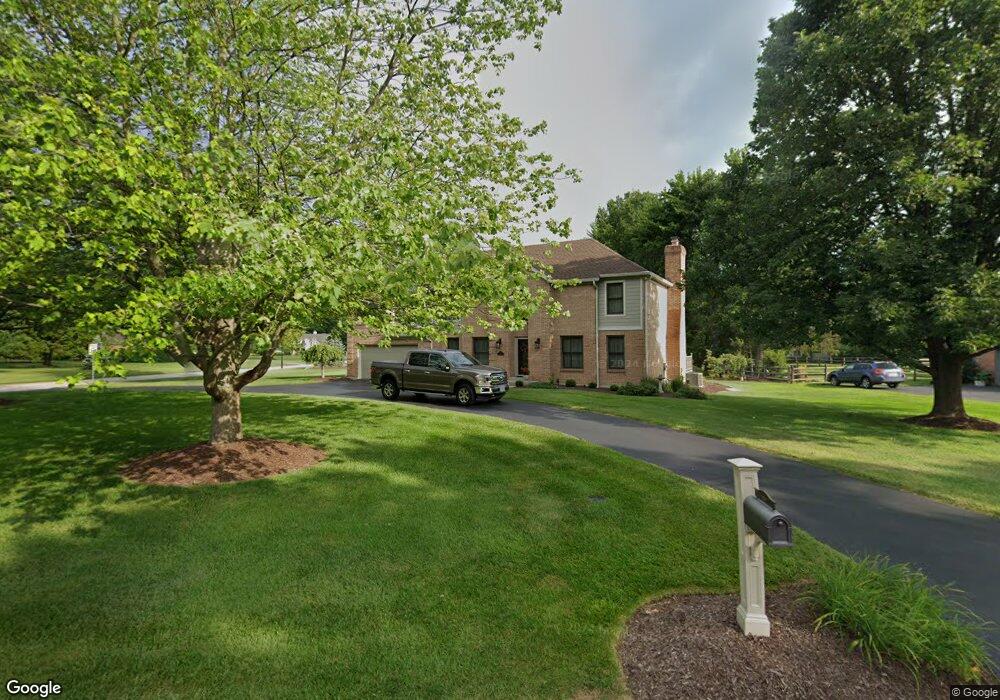
6342 S Devonshire Dr Loveland, OH 45140
Outer Loveland NeighborhoodEstimated Value: $506,000 - $554,000
4
Beds
4
Baths
2,830
Sq Ft
$187/Sq Ft
Est. Value
About This Home
This home is located at 6342 S Devonshire Dr, Loveland, OH 45140 and is currently estimated at $530,116, approximately $187 per square foot. 6342 S Devonshire Dr is a home located in Clermont County with nearby schools including Milford Senior High School, Milford Christian Academy, and St. Andrew - St. Elizabeth Ann Seton School.
Ownership History
Date
Name
Owned For
Owner Type
Purchase Details
Closed on
May 26, 1995
Sold by
Gayda Donald J
Bought by
Barnes David R and Barnes Sheila M
Current Estimated Value
Purchase Details
Closed on
Dec 1, 1989
Create a Home Valuation Report for This Property
The Home Valuation Report is an in-depth analysis detailing your home's value as well as a comparison with similar homes in the area
Home Values in the Area
Average Home Value in this Area
Purchase History
| Date | Buyer | Sale Price | Title Company |
|---|---|---|---|
| Barnes David R | $191,500 | -- | |
| -- | $176,000 | -- |
Source: Public Records
Mortgage History
| Date | Status | Borrower | Loan Amount |
|---|---|---|---|
| Closed | Barnes David R | -- |
Source: Public Records
Tax History Compared to Growth
Tax History
| Year | Tax Paid | Tax Assessment Tax Assessment Total Assessment is a certain percentage of the fair market value that is determined by local assessors to be the total taxable value of land and additions on the property. | Land | Improvement |
|---|---|---|---|---|
| 2024 | $6,087 | $130,130 | $21,910 | $108,220 |
| 2023 | $6,148 | $130,130 | $21,910 | $108,220 |
| 2022 | $5,596 | $90,160 | $15,750 | $74,410 |
| 2021 | $5,595 | $90,160 | $15,750 | $74,410 |
| 2020 | $5,360 | $90,160 | $15,750 | $74,410 |
| 2019 | $5,911 | $94,610 | $17,960 | $76,650 |
| 2018 | $5,923 | $94,610 | $17,960 | $76,650 |
| 2017 | $5,853 | $94,610 | $17,960 | $76,650 |
| 2016 | $5,737 | $82,990 | $15,750 | $67,240 |
| 2015 | $5,203 | $82,990 | $15,750 | $67,240 |
| 2014 | $5,203 | $82,990 | $15,750 | $67,240 |
| 2013 | $5,369 | $83,060 | $17,500 | $65,560 |
Source: Public Records
Map
Nearby Homes
- 1513 Charleston Ln
- 6379 Derbyshire Ln
- 6211 Cook Rd
- 1113 Clover Field Dr
- 6141 Brandywine Ct
- 6365 Ironwood Dr
- 6149 Century Farm Dr
- 5933 Firm Stance Dr
- 1331 Harbor Cove
- 1140 Weber Rd
- 6661 Paxton Guinea Rd
- 2013 Weber Rd
- 1803 Wheatfield Way
- 899 Murle Ln
- 709 Middleton Way
- 802 Andrea Dr
- 945 Paul Vista Dr
- 6469 Brittany Ln
- 6211 Spires Dr
- 955 Paul Vista Dr
- 6340 S Devonshire Dr
- 1511 Charleston Ln
- 6344 S Devonshire Dr
- 6323 S Devonshire Dr
- 6325 S Devonshire Dr
- 6338 Barrington Cir
- 1509 Charleston Ln
- 6321 S Devonshire Dr
- 6327 S Devonshire Dr
- 6346 S Devonshire Dr
- 1515 Charleston Ln
- 1507 Charleston Ln
- 6329 S Devonshire Dr
- 6336 Barrington Cir
- 6319 S Devonshire Dr
- 1516 Charleston Ln
- 6229 Tanglewood Dr
- 1510 Charleston Ln
- 1508 Charleston Ln
- 1506 Charleston Ln