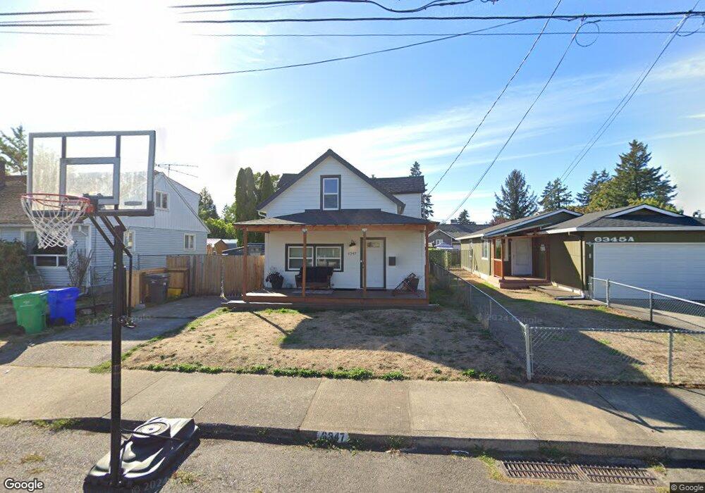
6347 SE 91st Ave Portland, OR 97266
Lents NeighborhoodEstimated Value: $389,000 - $455,000
3
Beds
2
Baths
1,292
Sq Ft
$333/Sq Ft
Est. Value
About This Home
This home is located at 6347 SE 91st Ave, Portland, OR 97266 and is currently estimated at $430,225, approximately $332 per square foot. 6347 SE 91st Ave is a home located in Multnomah County with nearby schools including Kelly Elementary School, Lane Middle School, and Franklin High School.
Ownership History
Date
Name
Owned For
Owner Type
Purchase Details
Closed on
Mar 7, 2022
Sold by
Cooke Betty J
Bought by
Cooke Allison W and Cooke Jamal
Current Estimated Value
Home Financials for this Owner
Home Financials are based on the most recent Mortgage that was taken out on this home.
Original Mortgage
$303,000
Outstanding Balance
$283,100
Interest Rate
3.92%
Mortgage Type
New Conventional
Estimated Equity
$147,125
Purchase Details
Closed on
Apr 25, 2019
Sold by
Cooke Jamal and Cooke Betty J
Bought by
Cooke Jamal and Cooke Betty J
Home Financials for this Owner
Home Financials are based on the most recent Mortgage that was taken out on this home.
Original Mortgage
$100,000
Interest Rate
4.3%
Mortgage Type
Credit Line Revolving
Purchase Details
Closed on
Jun 27, 2011
Sold by
Pratt Emily
Bought by
Cooke Jamal and Cooke Betty J
Home Financials for this Owner
Home Financials are based on the most recent Mortgage that was taken out on this home.
Original Mortgage
$153,974
Interest Rate
4.56%
Mortgage Type
FHA
Purchase Details
Closed on
Aug 25, 2003
Sold by
Lee Jon D
Bought by
Pratt Emily
Home Financials for this Owner
Home Financials are based on the most recent Mortgage that was taken out on this home.
Original Mortgage
$117,000
Interest Rate
5.87%
Mortgage Type
Purchase Money Mortgage
Purchase Details
Closed on
Jun 11, 2002
Sold by
Solberg Geir
Bought by
Lee Jon D and Lee Elizabeth A
Home Financials for this Owner
Home Financials are based on the most recent Mortgage that was taken out on this home.
Original Mortgage
$113,500
Interest Rate
6.43%
Mortgage Type
Purchase Money Mortgage
Purchase Details
Closed on
Sep 14, 1999
Sold by
Swensen Richard J
Bought by
Citifinancial Inc
Purchase Details
Closed on
Jan 25, 1995
Sold by
Gilmore Mary E
Bought by
Swensen Richard J and Swensen Lisl N
Home Financials for this Owner
Home Financials are based on the most recent Mortgage that was taken out on this home.
Original Mortgage
$85,500
Interest Rate
9.28%
Mortgage Type
Purchase Money Mortgage
Create a Home Valuation Report for This Property
The Home Valuation Report is an in-depth analysis detailing your home's value as well as a comparison with similar homes in the area
Home Values in the Area
Average Home Value in this Area
Purchase History
| Date | Buyer | Sale Price | Title Company |
|---|---|---|---|
| Cooke Allison W | $96,000 | Ticor Title | |
| Cooke Jamal | -- | Ticor Title Company Of Or | |
| Cooke Jamal | $158,000 | Chicago Title Company Oregon | |
| Pratt Emily | $130,000 | Ticor Title Insurance Compan | |
| Lee Jon D | $119,000 | Fidelity National Title | |
| Citifinancial Inc | $84,900 | Transnation Title Insurance | |
| Swensen Richard J | $90,000 | Fidelity National Title Co |
Source: Public Records
Mortgage History
| Date | Status | Borrower | Loan Amount |
|---|---|---|---|
| Open | Cooke Allison W | $303,000 | |
| Previous Owner | Cooke Jamal | $100,000 | |
| Previous Owner | Cooke Jamal | $153,974 | |
| Previous Owner | Pratt Emily | $117,000 | |
| Previous Owner | Lee Jon D | $113,500 | |
| Previous Owner | Swensen Richard J | $85,500 |
Source: Public Records
Tax History Compared to Growth
Tax History
| Year | Tax Paid | Tax Assessment Tax Assessment Total Assessment is a certain percentage of the fair market value that is determined by local assessors to be the total taxable value of land and additions on the property. | Land | Improvement |
|---|---|---|---|---|
| 2024 | $4,803 | $179,500 | -- | -- |
| 2023 | $4,803 | $174,280 | $0 | $0 |
| 2022 | $4,518 | $169,210 | $0 | $0 |
| 2021 | $4,442 | $164,290 | $0 | $0 |
| 2020 | $4,075 | $159,510 | $0 | $0 |
| 2019 | $3,925 | $154,870 | $0 | $0 |
| 2018 | $3,810 | $150,360 | $0 | $0 |
| 2017 | $3,652 | $145,990 | $0 | $0 |
| 2016 | $3,342 | $141,740 | $0 | $0 |
| 2015 | $3,254 | $137,620 | $0 | $0 |
| 2014 | $2,854 | $133,620 | $0 | $0 |
Source: Public Records
Map
Nearby Homes
- 6318 SE 93rd Ave
- 6131 SE 87th Ave
- 6126 SE 86th Ave
- 6524 SE 86th Ave
- 9328 SE Glenwood St
- 5843 SE 90th Ave
- 6604 SE 86th Ave
- 6530 SE 96th Ave
- 6417 SE 97th Ave
- 6336 SE 84th Place
- 9630 SE Foster Rd Unit 9634
- 6320 SE 97th Ave
- 5913 SE 86th Ave
- 6024 SE 84th Place
- 9746 SE Woodstock Blvd
- 5636 SE 88th Ave
- 6412 SE 83rd Ave
- 5628 SE 87th Ave
- 9910 SE Woodstock Blvd
- 7028 SE 86th Ave
- 6407 SE 91st Ave
- 6345 SE 91st Ave Unit A
- 6345 SE 91st Ave
- 6421 SE 91st Ave
- 6400 SE 90th Ave
- 6416 SE 90th Ave
- 6340 SE 90th Ave
- 6337 SE 91st Ave
- 6406 SE 91st Ave
- 6344 SE 91st Ave
- 6422 SE 90th Ave
- 6427 SE 91st Ave
- 6412 SE 91st Ave
- 6334 SE 91st Ave
- 6334 SE 90th Ave
- 6426 SE 90th Ave
- 6420 SE 91st Ave
- 6437 SE 91st Ave
- 6326 SE 91st Ave
- 6428 SE 91st Ave